I last left off on Christmas Eve in New York City. By then I had already spent two full days exploring the city, and I was completely enthralled. Christmas Day itself began at a slower pace. I had one more specific sightseeing objective in mind, and this was the day to finally do it — reaching the Brooklyn side of the East River, and possibly crossing the legendary Brooklyn Bridge.
Toward the South Side
I headed once more toward Manhattan’s southern neighborhoods.
This was now the third consecutive day of grueling long-distance walking across the vast urban landscape. Each morning I would wake up feeling relatively fresh, but it took less and less time for my lower back to begin aching again — the inevitable cost of solo travel on foot. From experience, I knew that after four or five days the body usually adapts, and the soreness gradually fades, but until then every step came with a reminder that cities like New York are best explored with stamina.
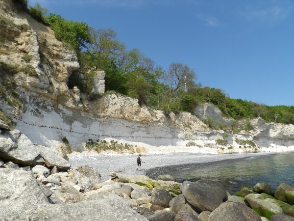
Beneath the grand arch and colonnade of the Manhattan Bridge approach in Chinatown, Lower Manhattan
My goal for the day was to cross over and do some sightseeing in Brooklyn Heights. I still wasn’t sure whether I would actually walk across the bridge or simply take the subway both ways.
As I mentioned earlier, I have an on-and-off irrational fear of heights, and tall bridges tend to give me the sweats. The Brooklyn Bridge, towering over the East River, certainly qualified. The more I thought about it, the more nervous I became — which is exactly how these phobias tend to work. The more attention you give them, the stronger they feel.
Chinatown and an Unexpected Historical Encounter
About half an hour later, I found myself back in Chinatown — though in a different section from the day before. Surrounded by Chinese storefronts, open street markets, and the towering Manhattan skyline in the background, I came across a monument dedicated to an important historical Chinese figure: Lin Zexu.
Chinatown hustle on Division Street under the Manhattan Bridge approach
Lin Zexu was a 19th-century Chinese scholar and official best known for his opposition to the opium trade during the Qing dynasty. Determined to combat the widespread addiction devastating Chinese society, he ordered the confiscation and destruction of large quantities of foreign opium in 1839. This decisive action contributed to the outbreak of the First Opium War between China and Britain.
Statue of Lin Zexu in Chatham Square in Chinatown, New York City
Today, Lin Zexu is remembered in China as a symbol of resistance against foreign exploitation and the fight against narcotics. His statue in New York’s Chinatown stands both as a tribute to his historical legacy and as a reminder of the Chinese community’s cultural heritage within the city.
A Brief Detour
As I continued walking, I found myself drifting toward the Lower East Side.
I’m not entirely sure what drew me there — perhaps curiosity sparked by its reputation as a once-grittier neighborhood. I didn’t stay long, but it was enough to see one of the distinctive cross-shaped public housing buildings up close.
Manhattan Bridge approach on Manhattan’s Lower East Side
I’m not sure what I expected — maybe something rougher or more intimidating — yet the area looked perfectly ordinary, even pleasant in places. Compared to some worn-down districts I had seen in Romanian cities, it felt surprisingly well kept. Perhaps the old stereotypes about dangerous New York neighborhoods had simply lingered longer than the reality, or maybe the holiday season had added an extra layer of calm to the streets.
After the short detour, I returned to the Two Bridges neighborhood.
Winter Wonderland at the Seaport
From this closer vantage point, the Brooklyn Bridge appeared even more imposing. If I was going to walk across it, I decided, it would be better to start from the Brooklyn side, with the Manhattan skyline stretching out in front of me. But before committing to the crossing, I made my way toward the Seaport District, curious to see what awaited along the waterfront.
The Seaport District
The Seaport District was a completely different version of Lower Manhattan. In contrast to the densely packed towers of the nearby Financial District, the waterfront opened into a broad, airy space stretching out toward the East River. The area was like a breath of fresh air from the shaded urban canyons right next to it.
A slice of New York City’s maritime past that helped build the financial powerhouse it became today
In the 19th century, this waterfront was one of the busiest ports in the world, serving as a crucial gateway for trade and immigration into the rapidly growing United States. Many of the surrounding streets still preserve restored mercantile buildings from that era, reminders that long before Wall Street’s dominance, maritime commerce was the engine that powered Lower Manhattan’s rise.
The soaring Manhattan skyline from the rooftop at Pier 17
Today, the neighborhood balances that historical identity with modern redevelopment, turning former shipping piers into cultural and entertainment spaces without losing the character of the old harbor.
Pier 17
The holiday centerpiece of the area was Pier 17, a redeveloped waterfront complex that blends restaurants, event spaces, and public gathering areas with sweeping panoramic views. Throughout the year, the rooftop hosts concerts and cultural events, but during the winter season it transforms into Winterland, New York City’s only outdoor rooftop ice-skating rink. Warming stations, seasonal drinks, and cozy seating areas create a festive atmosphere that continues well beyond the Christmas holidays, drawing both locals and visitors who want to enjoy the skyline from an unusual vantage point.
Pier 17’s outdoor rooftop ice rink with some of the best views in the city
From the steps near Pier 17, the views were easily among the best in the city. The Brooklyn Bridge stretched across the East River in full profile, framed by the Manhattan skyline on one side and Downtown Brooklyn rising on the other. Prices at the rooftop venues were, unsurprisingly, steep, so I settled for something simpler — finding a comfortable spot along the steps, unpacking my sandwich, and letting the skyline provide the scenery for lunch. Honestly, some of the best experiences in New York are the ones that cost nothing at all.
An exceptional view of the stone tower of the Brooklyn Bridge from Pier 17
This was to get a good overall feel of the Brooklyn Bridge. The proximity made the decision I had been postponing impossible to ignore. Watching the pedestrian walkway suspended high above the traffic below stirred my unease more than I expected. I zoomed in with my camera, capturing people calmly crossing — tiny silhouettes against the cables and towers — and realized that I was unintentionally feeding my own anxiety. The longer I stood there observing, the more my thoughts began to spiral, turning a simple walk across the river into a mental challenge far larger than it needed to be.
A close-up of the Williamsburg Bridge’s, once the longest suspension bridge in the world
Just southwest of Pier 17, helicopters rose and descended in a steady rhythm from the nearby heliport, carrying visitors on aerial tours of the city. Strangely, the idea of flying in one of those enclosed cabins didn’t trigger the same reaction; it was open elevated spaces that unsettled me, not height itself — an odd quirk of the mind. In the end, however, the decision was made easier by the steep ticket prices, and I was content to remain firmly on the ground, watching the aircraft circle above the skyline.
The towering One World Trade Center catching the light like a beacon
After resting for a while and enjoying the waterfront views, it was finally time to continue the journey. Brooklyn awaited on the other side of the river, and I made my way toward the nearest subway station, still undecided about how — or whether — I would eventually face the bridge itself.
Brooklyn Heights Promenade
A short subway ride later, I emerged in Brooklyn. I hadn’t planned an extensive itinerary for this side of the river; my main goal was simple — to see the Manhattan skyline from across the water. Brooklyn offers no shortage of neighborhoods worth exploring, but with the afternoon already slipping away, I decided to focus on one destination I knew wouldn’t disappoint: the Brooklyn Heights Promenade.
The panoramic view of Downtown Manhattan from Brooklyn Heights
Somewhere in the back of my mind I also remembered the famous photo location where the Manhattan Bridge is perfectly framed between rows of buildings — though, at the time, I had mixed up my bridges and assumed the shot featured the Brooklyn Bridge instead. Realizing I was in the wrong neighborhood, I chose not to “cheat” by immediately looking it up online and instead followed instinct, heading toward the promenade. I may not have found the Instagram-famous street, but what I discovered instead proved far more rewarding.
The soaring Neo-Gothic crown of the Woolworth Building
The elevated walkway of the Brooklyn Heights Promenade offered what were easily 10-out-of-10 panoramic views of Lower Manhattan. From this distance, the skyscrapers appeared almost at eye level, allowing me to capture some of my favorite zoomed-in skyline photographs of the entire trip — a rare treat without having to purchase yet another expensive ticket to a skyscraper observation deck.
A 25-foot-tall Roman goddess figure holding a five-pointed mural crown symbolizing New York City’s five boroughs crowns the Municipal Building’s lantern-like top
A persistent winter wind swept along the waterfront, but the cold hardly mattered. I lingered there for quite some time, resting my sore back while watching the late-afternoon light settle over the city.
A slightly tired windswept look from Brooklyn Heights
It was also here that I finally made peace with my decision not to walk the Brooklyn Bridge that day. Had I been traveling with someone, or even surrounded by a larger group, the anxiety might have faded. Crowds often create a strange sense of security, but alone, the idea of being halfway across the bridge with no easy escape if panic set in felt unnecessarily daunting. Combined with the miles already walked and the growing fatigue in my legs, the choice became simple: the crossing would wait for another visit. Some landmarks, it seems, are best left as unfinished business — a reason to return.
A Night on Broadway
For the evening of December 25, however, I had planned something special. While researching things to do in New York, I had repeatedly encountered one unmistakable recommendation: see a Broadway show. Theater had never been a major part of my life — aside from a few opera visits, I wasn’t much of a theatergoer, and certainly not a musical enthusiast. Ticket prices were also steep, as expected in New York. Still, I felt that if there was anywhere in the world to give musical theater a genuine chance, this was it.
An extraordinary show awaits at the Majestic Theater
Looking through the available performances, one title stood above all others: The Phantom of the Opera. I knew the musical only through its iconic main theme, which I had first discovered through a cover by a Finnish metal band I followed, and I had never even seen the film adaptation. Yet the music had always fascinated me, and nearly every recommendation I encountered described the show as a must-see Broadway classic. That was enough — I bought a ticket, setting the stage for my first-ever Broadway musical.
The elegant interior of the Majestic, with show just about ready to start
From the moment the overture thundered through the theater, I knew I had made the right decision. Even seated far toward the back, unable to catch every visual detail, the scale of the performance, the staging, and the powerful music completely captivated me. Songs such as Think of Me, Music of the Night, All I Ask of You, and The Point of No Return instantly became favorites.
The Show Must Go On
Leaving the theater that night, I found myself unexpectedly moved. While strolling back to my hotel, taking in the nightly splendor of the city the melodies from the show kept playing in my mind. I’d later spend hours reading about the story, the performers, and the history of the production.
Midtown holiday glow on the 25th of December
That evening did more than entertain me — it opened the door to an entirely new appreciation for musical theater and quietly started a tradition I still follow today: revisiting the remarkable 25th Anniversary performance featuring Ramin Karimloo and Sierra Boggess each holiday season.
New York had done it again. This time it wasn’t the towering architecture or the dramatic skyline that left the strongest impression, but the city’s artistic soul — its ability to tell stories on a grand stage and leave visitors carrying those emotions long after the curtain falls.
Museums Days
With only a couple of days remaining in New York, I decided to dedicate them to museums. The real challenge wasn’t finding something interesting to visit — it was narrowing down the overwhelming number of world-class options the city offers. As a geologist and lifelong enthusiast of natural history, the American Museum of Natural History was a mandatory choice. The second museum would require more thought, but one thing was certain: this day belonged entirely to the natural world.
The American Museum of Natural History
Before heading out on the morning of December 26, I made one practical decision — eat a serious breakfast. I had a feeling I would spend most of the day inside the museum and might not stop for lunch, so I searched for a nearby breakfast spot and ended up at a familiar American name: IHOP. I couldn’t quite remember where I had first heard of it — probably movies or television — but curiosity was enough to draw me in.
American breakfast breaking the carbs-o-meter
What followed was a lesson in American portion sizes. I ordered a bacon-cheese-vegetable omelet, accompanied by pancakes and a hot chocolate, expecting a modest meal. Instead, I was presented with what felt like a feast: a fully loaded omelet that could easily have been a complete meal on its own, followed by a towering stack of pancakes topped off with butter, and a mug of hot chocolate closer in size to a soup bowl than a cup. It was undeniably tasty and satisfying, but absolutely overwhelming. By the time I stepped back onto the street, I felt as though I needed a short walk just to recover from the sheer caloric impact before continuing toward the subway.
The American Museum of Natural History
Located along Central Park West, directly across from the park itself, the American Museum of Natural History (AMNH) is one of the largest and most influential scientific museums in the world. Founded in 1869, it has grown into a vast complex of exhibition halls, research facilities, and collections numbering in the tens of millions of specimens.
Eyes on the stars, feet on the ground: Theodore Roosevelt’s enduring wisdom to youth inscribed on the wall of the American Museum of Natural History
From the moment I arrived, the scale of the institution was clear: long ticket lines, guided tour groups gathering near the entrance, and a steady stream of visitors flowing through the historic halls.
The large crowd of visitors beneath the mighty Apatosaurus in the Theodore Roosevelt Rotunda
Stepping into the Theodore Roosevelt Rotunda, I was immediately greeted by towering displays, including the enormous Apatosaurus skeleton — a fitting welcome into a museum where deep time and natural history unfold on a monumental scale. As a geologist, I felt an almost childlike excitement from the very first moments. Dinosaur fossils alone would have justified the visit, yet they were only one part of an immense journey that would stretch across the entire day.
From Wildlife to Civilizations
My journey started in the halls dedicated to the wildlife and cultures of Africa, where carefully crafted dioramas displayed animals in lifelike environments — meticulously preserved taxidermy scenes designed to represent ecosystems in remarkable detail.
African wildlife diorama presenting a family of lions
Beyond the wildlife halls, the museum gradually transitioned into the story of humanity itself. The Hall of African Peoples explored the diversity of societies across the continent. Intricately carved masks, ceremonial garments, musical instruments, and everyday objects illustrated how art, spirituality, and daily survival were deeply intertwined across different African cultures.
Ceremonial beaded figure, possibly a bird or animal effigy used in rituals
Moving onward, the journey shifted to the civilizations of Mesoamerica, where the Olmec, Maya, and Aztec cultures were presented not merely as ancient societies, but as sophisticated centers of knowledge and innovation. Monumental stone sculptures, most strikingly the colossal Olmec heads, hinted at powerful rulers and complex ceremonial traditions.
The colossal Olmec head replica in the AMNH’s Mesoamerican hall
Exhibits described how these civilizations developed advanced calendrical systems, astronomy, urban planning, and large-scale architecture long before European contact, achievements that reshaped my understanding of what “Stone Age” classifications actually mean in a cultural sense. Technologically they lacked widespread metal tools, yet intellectually and artistically they were extraordinarily advanced.
A magnificent Plains Indian war bonnet
Among the most recognizable pieces in this section was the Aztec Stone of the Sun, whose famous original is housed in Mexico City; the museum displays an accurate replica that allows visitors to study the intricate carvings representing cosmology, mythological cycles, and ritual symbolism.
The legendary Aztec Sun Stone replica in the AMNH
Nearby, smaller artifacts like jade carvings, ritual tools, jewelry, and ceremonial masks, revealed the refined craftsmanship of these societies, emphasizing that daily life, religion, and political power were often inseparable.
Origins of Humanity and Geology Time
I continued through the paleoanthropology halls, where the exhibits trace the long evolutionary pathway of our species. Reconstructions of early hominins, alongside casts of landmark fossil discoveries — including the famous Australopithecus afarensis specimen “Lucy” — place human history within a vast biological continuum stretching back millions of years.
Lucy’s legacy: The famous 3.2-million-year-old Australopithecus afarensis cast stands as a bridge between apes and humans, showcasing upright walking in AMNH’s Hall of Human Origins
Moving onward into the geological collections, the focus shifts from biological evolution to the processes that shaped the Earth itself. One of the immediate centerpieces was the massive iron meteorite — a multi-ton remnant of early solar system formation. Standing beside it, I couldn’t help but imagine a rock like that impacting the planet. It happened plenty of times in the past and still does occasionally in our times.
Ahnighito (Cape York meteorite fragment) in the Arthur Ross Hall of Meteorites
Among the museum impressive ore samples, and polished crystal displays one piece that particularly caught my attention was the huge stibnite display — an unmistakable mineral due to its elongated metallic crystal habit. Having grown up in a historic mining town where such sulfide minerals were once extensively extracted, I had seen many smaller examples in private collections — a small slice of familiarity.
This half-ton stibnite specimen, with hundreds of sword-like antimony crystals, is one of the world’s largest on public display in AMNH’s gem halls
The section concluded with a return to the living world and a striking visual reminder of time itself: the cross-section of a giant sequoia trunk. Each growth ring marks a single year, with historical events labeled across the centuries, turning the tree into a living chronological record.
Dinosaur Halls: Childhood Awe Revisited
Hours passed almost unnoticed as I navigated the museum’s maze-like corridors, eventually realizing it was already afternoon and I still hadn’t reached the dinosaur halls. Once there, the crowds alone made it clear I had arrived at one of the museum’s most celebrated attractions.
The massive skeleton of the carnivorous Allosaurus
Towering skeletons of Tyrannosaurus rex, Triceratops, Stegosaurus, Styracosaurus, and numerous theropods filled the galleries, while nearby displays showcased prehistoric mammals such as mammoths and the armored Glyptodon. For anyone who grew up fascinated by prehistoric life, the experience was unforgettable — a moment where childhood curiosity and adult knowledge meet in the same sense of awe.
A childhood favorite: Stegosaurus, whose brain was roughly the size of a lime… but whose charm is absolutely enormous
Unsurprisingly, nearly everyone in the hall seemed determined to capture a photo with the legendary Tyrannosaurus rex, myself included. Watching the crowd pose beneath the massive jaws instantly brought back memories of childhood evenings spent glued to documentaries like Walking with Dinosaurs and, of course, the unforgettable original Jurassic Park — still the benchmark that modern cinema has struggled to surpass despite endless sequels.
Your boy together with big boy T-rex
Dinosaurs, however, were only part of the spectacle. Surrounding galleries displayed a wide array of prehistoric and more recent skeletons, illustrating the broader story of life across different eras. Massive Ice Age mammals such as mammoths and the armored Glyptodon stood alongside other striking specimens, while nearby displays featured long, coiling skeletons of giant reptiles such as large pythons and other vertebrates.
A colossal reticulated python skeleton. Quite impressive and slightly nightmare-inducing
By the time I finished exploring the final halls, the museum was already approaching closing hours. What I had expected to be a half-day visit had quietly expanded into a full-day immersion, morning to late afternoon, yet I wasn’t even sure if I’d visited all of the museum’s sections.
Evening Reflections
Leaving the museum, tired but deeply satisfied, I slowly made my way back across the city.
I found myself strolling passed landmarks such as Carnegie Hall and Radio City Music Hall, reflecting on how much the city had already come to mean to me. Somewhere along that evening walk, a quiet realization settled in: I didn’t just enjoy visiting New York — I wanted, at least for a time, to live there.
Radio City Music Hall with the towering Christmas tree
I began wondering how my career path might someday align with that dream, imagining the possibility of working in industries that could eventually allow me to spend several years in the city. Whether realistic or distant, the idea stayed with me, quietly motivating future ambitions.
By now, navigating Manhattan had started to feel natural. I had learned the subway system, discovered affordable places to eat, and grown comfortable moving through neighborhoods that only days earlier had seemed overwhelming. I felt less like a visitor and more like someone temporarily woven into the rhythm of the city — though the approaching final day reminded me that the journey was nearly over.
Giant red ornaments fountain at 1251 Avenue of the Americas
One full day remained, and it promised a surprise discovery that would once again reshape my awe of what this city had to offer.
Steel, Speed, and Storm Clouds: The Intrepid Surprise
On my last full day in New York, the weather began to shift. The warm, sunlit skies that had welcomed me and lingered faithfully throughout the week slowly gave way to a gathering front of murky clouds. Rain was forecast for the days ahead — the days following my departure. It felt almost poetic, as though the city itself sensed the approaching farewell. The brightness that had framed my arrival softened into grey, and I found myself matching the mood, reluctant to let the experience end.
Playful bronze cleaners from Tom Otterness’s ‘Life Underground’ at 14th Street/Eighth Avenue station, sweeping up giant coins in the NYC subway
I had already made my museum choice for the day, though it hadn’t been an easy decision. The Metropolitan Museum of Art would have been the natural follow-up to the American Museum of Natural History — another giant, another essential New York institution. But after immersing myself so deeply in natural history and human civilization the day before, I felt that doubling down on a similar historic-cultural theme might be too overwhelming and reduce the experience rather than enrich it.
While researching alternatives, another museum caught my attention. From the few online images I checked, it appeared to be a war museum — fighter jets, naval vessels, military hardware. That alone intrigued me; I’ve long had an appreciation for military engineering and history. But the true selling point was a single photograph: the SR-71 Blackbird. An absolute legend of aviation — a reconnaissance aircraft capable of exceeding Mach 3, still holding speed records decades after its retirement.
The Legendary SR-71 Blackbird. Honestly, a photo pretty much like this one was basically the only thing I knew about the Intrepid Museum before I actually showed up in person.
That image was enough. I didn’t read much further. I booked the ticket with only a vague idea of what awaited me, unaware that this choice would turn out to be one of the most memorable surprises of the entire trip.
A Floating Giant on the Hudson
After another big breakfast at IHOP — it had served me well the day before — I headed out toward the Intrepid Sea, Air & Space Museum, located along Manhattan’s western edge in the Hell’s Kitchen district. A curious name for a neighborhood. Contrary to what one might assume, it has nothing to do with fine dining gone wrong; the nickname likely dates back to the 19th century, when the area was known for overcrowded tenements, gang activity, and a rough reputation that made it seem, to some, like a “kitchen of hell.” Today, however, the streets feel far removed from that past — busy but orderly, framed by modern high-rises and river views.
Long line of visitors waiting to enter the Intrepid Sea, Air & Space Museum
It wasn’t until I reached the Hudson River and saw the museum up close that I realized what this place actually was. I had expected a building on a pier with aircraft displayed on the rooftop. Instead, I was greeted by a modest-sized entrance structure with museum signage — and beside it, an enormous aircraft carrier with the name Intrepid painted across its towering hull. Then I noticed the unmistakable silhouette of the SR-71 parked on its deck.
My eyes widened. My jaw may very well have followed.
Welcome aboard the USS Intrepid
I hadn’t realized that “Intrepid” wasn’t just the name of the museum. It was the USS Intrepid, a World War II–era aircraft carrier that had been transformed into the museum itself.
Steel, Supersonic Icons, and Cold War Titans
I’ve come to appreciate visiting places with only minimal prior research — just enough to spark curiosity, but not so much that the experience feels pre-digested. Discovering things in person, rather than through a screen beforehand, often makes them more vivid and memorable. In the case of the Intrepid, that approach paid off in droves, with one major surprise following another.
Flight deck panorama on USS Intrepid. From left to right: AV-8C Harrier, UH-1 Huey, T-28 Trojan, and HH-52A Seaguard, with the NYC skyline across the Hudson.
As I passed through ticket control and entered the courtyard, the magnitude of the place began to sink in. The USS Intrepid (CV-11) an Essex-class aircraft carrier commissioned in 1943 had served in World War II, the Cold War, Vietnam, and as a NASA recovery ship. After decommissioning in 1974 and facing scrapping, it was saved through a public campaign and opened as the centerpiece of the Intrepid Sea, Air & Space Museum in New York City in 1982.
But that wasn’t all. As mind-blowing as it already was to explore a real WWII-era warship turned museum, I quickly realized Intrepid had even more legendary icons on display.
Hangar deck aboard Intrepid Featuring a Grumman F6F Hellcat
Moored alongside the pier stood another legend of engineering: one of the few remaining Concorde jets on public display anywhere in the world. Sleek, impossibly elegant, and once capable of carrying passengers across the Atlantic at twice the speed of sound. The museum offered an interior tour for an additional fee. Tempting — very tempting — but for the moment I was content admiring its aerodynamic perfection from the outside.
The Concorde — the only supersonic passenger airplane to date that saw service from 1976 until its retirement in 2003
On the opposite side of the carrier rested yet another surprise: the USS Growler, the only American nuclear missile submarine open to the public. Like the Concorde, it offered interior tours for an extra charge. The idea of stepping inside a Cold War submarine was undeniably appealing.
The USS Growler, one of the first US cruise missile submarines used as a nuclear deterrent
But first things first. I had an aircraft carrier to explore.
A short climb up a flight of stairs later, I found myself stepping aboard something I had never truly imagined I would enter in my lifetime. I was grinning like a kid.
Life Below Deck
My tour began in the Mess Deck. Informational panels detailed the complex logistics of feeding thousands of sailors during extended deployments at sea — a delicate balance between ensuring sufficient provisions and avoiding waste. It was a reminder that beyond combat operations, an aircraft carrier is also a floating city that must sustain itself.
Stacked pipe-berth bunks in the enlisted sleeping quarters
Narrow metal corridors branched into compact dining spaces and tightly arranged sleeping quarters. Every square meter had a purpose; efficiency dictated the architecture. Function over comfort. Steel over softness.
The Optical Landing System (OLS) lights, used for signaling aircraft during carrier landings
Eventually the passageways opened into a larger exhibition area filled with displays, models, and multimedia presentations. Military aircraft components, signaling equipment, naval guns, massive propellers, space capsules — and even a meticulously constructed LEGO replica of the Intrepid. I couldn’t help but think how satisfying it must have been to be part of the team that built it.
Massive 250,000-piece brick replica of the carrier, complete with flight deck details and crew figures
One display board listed confirmed wartime achievements: over five dozen enemy ships sunk during World War II, with many more damaged. Across the room, in striking contrast, an exhibit titled “Navy Cakes: A Slice of History” explored the tradition of baking aboard naval vessels — complete with recipes, photographs, and stories. According to the exhibit, cakes were baked on the USS Intrepid both regularly and for special occasions.
Intrepid’s tally of Japanese planes and ships damaged or sunk during Pacific campaigns
War and cake. Destruction and celebration. An oddly human juxtaposition.
Holt mixer and period ingredients from Intrepid’s cake-baking history (part of the ‘Navy Cakes: A Slice of History’ display)
Interactive exhibits, including flight simulators, filled other corners of the hall. The atmosphere felt almost like a busy convention center, people flowing from station to station. And yet, every so often, it would hit me again:
I was inside an actual aircraft carrier.
How absurdly cool is that?
Guns, Steel, and a Sudden Vertigo
After thoroughly exploring the interior, I stepped outside onto one of the lower exterior decks along the starboard side, beneath the overhang of the flight deck above. From there, I made my way upward along the ship’s structure, passing preserved anti-aircraft guns — single and multi-barreled mounts still fixed in position.
Boys, I think aiming in the wrong direction here
Now they pointed toward Manhattan. Oh, how the guns have turned.
Eventually I reached the flight deck. And that’s when the vertigo hit.
Double-barrel anti-aircraft guns
In all the excitement, I hadn’t fully registered how high up I had climbed. Suddenly I was standing on an open, elevated platform with minimal visual barriers, almost at eye level with surrounding skyscrapers. The openness of the deck amplified everything. My irrational fear kicked in hard.
Legs went weak and palms started sweating. For the first few minutes, I stuck close to the island structure — the carrier’s central tower — trying to appear casual while moving in a way that probably made it look like I had shat myself.
Setting foot on the USS Intrepid’s flight deck, one shaky foot at a time
As amusing as it is to write about now, it was deeply frustrating in the moment. Anxiety has a way of hijacking reason. But slowly, minute by minute, I regulated my breathing. The fight-or-flight response eased. The deck stopped feeling like a cliff edge and started feeling like a museum again.
And then I could finally look up.
An Aviator’s Dream
The flight deck was an aircraft enthusiast’s banquet.
The collection spanned decades of U.S. naval aviation, from World War II through Korea and Vietnam. Highlights included the Grumman E-1B Tracer — an early carrier-based airborne early warning aircraft — the Grumman F11F Tiger, once flown by the Blue Angels, and the iconic Grumman F-14 Tomcat, forever immortalized by Top Gun.
Grumman F11F Tiger, used by the Blue Angels — the US Navy’s famous demonstration team
There were also international icons: the British AV-8C Harrier and the Israeli IAI F-21A Kfir.
And then — the reason I had come. The SR-71 Blackbird.
It was far larger than I had imagined. Significantly larger than the surrounding aircraft. Its elongated fuselage, sharp chines, and twin engine nacelles gave it an almost alien silhouette. Even standing still, it radiated speed. This machine had cruised above Mach 3. It had outrun missiles.
The Blackbird was so large it was impossible to frame it well in any one photo
Seeing the SR-71 in person was deeply satisfying. A marvel of engineering born from Cold War necessity, now resting peacefully atop a retired warship.
On the far end of the deck stood a large canopy structure, almost resembling a temporary hangar. From the outside, it revealed nothing of what lay within.
Grumman F-14 Tomcat, an iconic variable-sweep fighter
I didn’t yet know what awaited me there. But I was about to discover the final, and perhaps greatest, surprise of the day.
An Unexpected Journey into Orbit
I stepped inside the canopy structure and was immediately enveloped in a dim, almost reverent atmosphere. The lighting was low, deliberate — as if encouraging silence. And there, housed within the darkness, stood one of the greatest achievements of modern aeronautical and space engineering.
Enterprise. The first prototype Space Shuttle orbiter ever built.
Enterprise — the cherry on top of the cake at the Intrepid Museum
At that moment, the Intrepid Museum had officially claimed the title of my best museum experience to date.
Rolled out in 1976 and named after the iconic Star Trek starship following a fan letter-writing campaign to President Gerald Ford, Enterprise was constructed as a test vehicle. Lacking heat shielding and full engines, it was never intended for orbital flight. Instead, it played a critical role in the Shuttle program’s development by conducting the Approach and Landing Tests in 1977. Released unpowered from a modified Boeing 747 carrier aircraft, the orbiter validated aerodynamic performance, handling characteristics, and landing procedures — proving that the revolutionary concept of a reusable winged spacecraft could function safely within Earth’s atmosphere.
The data gathered from those flights provided the confidence necessary to proceed with the operational fleet, beginning with Columbia’s first orbital mission in 1981. Without Enterprise, the Space Shuttle program as we know it would not have been possible.
RICOH IMAGING
Standing beneath it, I was struck by how beautiful it truly was. I had grown up seeing its sister orbiters in documentaries, textbooks, and news broadcasts. But seeing one in person is an entirely different experience. Even though Enterprise itself never reached space, it represented the gateway to an era when shuttles routinely carried astronauts to orbit and back. That realization was unexpectedly moving.
Its sheer size was impressive enough, but what fascinated me most up close was the underside. The black, plate-like surface was covered in high-temperature reusable insulation tiles coated in borosilicate glass. These tiles were engineered to withstand the extreme heat of atmospheric reentry, radiating absorbed heat away and protecting the aluminum structure beneath. Roughly 90% of the intense thermal energy encountered during reentry would be reflected or dissipated back into the atmosphere.
The black insulation tiles on the bottom of the orbiter
It was an extraordinary feat of engineering — elegant, functional, ambitious. Knowing that the Shuttle program has since been retired made the moment feel even more significant.
From Bridge to Skyline
After marveling at Enterprise and the surrounding space exhibits, I stepped back out onto the flight deck. There was one final section of the carrier left to explore: the island structure — the ship’s command tower.
From the island’s exterior lookout mirror: a quirky, wide-eyed glimpse of Intrepid’s deck life with the Hudson and skyscrapers peeking in
Climbing several narrow staircases, I moved through various control and operations rooms. From the Combat Information Center to the navigation bridge, the spaces were filled with original equipment and interpretive displays. Classic green radar scopes glowed behind glass, alongside navigation systems and communication panels that once coordinated real operations at sea.
Classic PPI radar scope displaying surface or air contacts
A small, modest cabin marked the chief of staff’s quarters — compact, functional, unadorned. Higher up was the captain’s bridge. There, visitors had the opportunity to speak briefly with a senior staff member and veteran who had once served aboard the Intrepid. Listening to him recount stories from his service days felt surreal, as though I had momentarily stepped into a living documentary. It was a genuine privilege to meet him and exchange a few words.
Weird architecture alert! Captured from USS Intrepid, VIA 57 West rises as a gleaming, angled tetrahedron amid the Manhattan skyline
Stepping out onto the top of the island offered sweeping panoramic views of the Hudson and the Manhattan skyline. No vertigo this time, thankfully. I could simply stand there, steady and present, taking in both the city and the realization that this museum visit had far exceeded every expectation.
Back on the hangar deck, I lingered as closing time approached. With the crowds thinning, I finally had the chance to try some of the interactive exhibits I had missed earlier. When I disembarked the aircraft carrier — a sentence I still can’t quite believe I get to write — dusk had begun settling over the river.
The Bell H-13 Sioux famously depicted in the MASH* TV series, on display as an interactive exhibit at Intrepid
There was just enough time left for one more tour.
I would have gladly done both the Concorde and submarine tours, but time forced a choice. I chose the Growler.
Steel Beneath the Surface: USS Growler
Commissioned in 1958 and active during the height of the Cold War, the USS Growler (SSG-577) was a guided missile submarine designed to carry and launch the Regulus I nuclear cruise missile. Unlike later ballistic missile submarines, Growler had to surface to fire its payload, making its missions both complex and perilous. As the Navy transitioned to more advanced nuclear-powered ballistic missile submarines armed with Polaris missiles, Growler was decommissioned in 1964 after only six years of service.
Heart of the sub: USS Growler’s control room periscope column
After decades in reserve and facing possible scrapping, the submarine was ultimately preserved thanks to the efforts of Zachary Fisher, founder of the Intrepid Museum. It opened to the public in 1989 and remains the only American guided missile submarine accessible for tours — a rare and sobering Cold War artifact.
Moving through its compartments was an entirely different experience from touring the carrier above. If the Intrepid felt efficient, the Growler felt compressed. Every inch of space served a purpose. From the torpedo room to the engine room, from sonar stations to crew quarters, the submarine was a masterclass in spatial economy.
The forward torpedo room deep inside the USS Growler
The bunks were tiny, built directly into the superstructure and easy to miss at first glance. Fold-out boards doubled as tables. Storage was integrated into every possible corner. Even on a brief walkthrough, the claustrophobic intensity of life aboard became palpable.
Ironically, the confined space did not bother me in the slightest. While open heights trigger my vertigo, enclosed steel corridors felt oddly comfortable. Crawling through the narrow passageways and even stepping inside the missile compartment felt more fascinating than intimidating.
The Regulus I, the first US submarine-launched nuclear-warhead cruise missile
The Regulus I missile itself, the submarine’s nuclear payload, was mounted on top of the submarine. Resembling a small unmanned aircraft, the turbojet-powered cruise missile carried a nuclear warhead with a yield measured in megatons. It was the U.S. Navy’s first operational nuclear cruise missile, a technological bridge between World War II’s V-1 concept and modern cruise missile systems.
Standing inside the vessel that once carried such weapons was sobering. This was not just engineering — it was the physical embodiment of Cold War deterrence.
A Museum That Surprised Me at Every Turn
With my tour of the Growler complete, the museum day came to an end. As much as I try, it’s difficult to fully express how much I enjoyed my visit to the Intrepid Sea, Air & Space Museum.
What began as a simple decision based on a photograph of the SR-71 and a high rating turned into an entire day of escalating discoveries. An aircraft carrier. A Concorde. A nuclear submarine. The Space Shuttle Enterprise. A conversation with a veteran who had served aboard the very ship I was standing on.
One final look at the USS Intrepid towering over the Hudson at Pier 86
Some might raise an eyebrow at calling it my favorite museum experience to date. But for someone deeply fascinated by aviation, spaceflight, and military history, this was peak alignment between interest and experience. It wasn’t just the scale of the exhibits — it was the way they were presented, layered, and preserved with care.
So I want to close this chapter with a simple and sincere thank you to the people who made and continue to maintain this museum. Preserving a World War II carrier, a Cold War submarine, a Concorde, and a prototype Space Shuttle in one accessible space is no small undertaking. For visitors like myself, curious, enthusiastic, and perhaps slightly overwhelmed, the Intrepid offers not just artifacts, but perspective.
Walking back to the hotel on my last night in New York City
As a foreign visitor and admirer of American innovation and history, I left with genuine respect. And a salute.
One Last Walk
The day had come to leave New York City behind. I knew with certainty that I would return; the city had left a deeply positive impression on me. Even so, the moment of departure carried a quiet sadness. With an evening flight still ahead, I decided to top off my visit with one final stroll across Manhattan.
The final stroll across the city on the day of my departure
Baggage in hand, I set out toward some of the Midtown locations that had become so familiar by now. Starting at Madison Square Park, my default sanctuary from the very first day, I bid farewell to the park’s energetic squirrels before continuing toward the Empire State Building.
A close-up of the New York Life Building’s dazzling gilded pyramid roof towering over Madison Square
Checking my route along the way, I decided to head east to catch one final landmark: the United Nations Headquarters on First Avenue. As if offering a parting gift, the weather cleared for one last bright afternoon, allowing me to fully enjoy these final hours walking the streets of New York.
The United Nations Secretariat Building rising over the East River
Once satisfied, I took the subway for the last time, heading back toward Queens and then to LaGuardia Airport. And so ended one of my favorite Christmas holidays to date — a week-long adventure filled with discoveries, excitement, and moments that crowned 2019 as one of the best years of my life.
Enjoying the East River skyline one last time before heading home
It was time to return to the frozen north and resume my academic life as a PhD student in Chicoutimi, Quebec — already carrying the quiet certainty that this would not be my last chapter with New York City.
December 2019. Four months after moving to Canada, I was reaching the end of my first semester as a PhD student. Everything culminated in the research proposal exam — a final test of worthiness, and the last hurdle before I could continue the remaining three years as a PhD candidate without anything hanging over my head.
I had promised myself a reward if I passed.
The day finally came. I dressed up properly, delivered my presentation smoothly, and endured the intense heat of the examiners’ questions — coming out of it medium-rare, but successful. With the exam passed and the weight finally lifted, the realization hit me all at once.
Holy crap… I was going to New York City!
Planning Nothing, Going Everywhere
As with my trip to Greece earlier that year, I didn’t plan much in advance. I booked my flights, found a place to stay, and figured I’d improvise the rest once I got there.
The journey itself came in two legs: from Bagotville–Saguenay to Montreal, and then from Montreal to New York City.
A sleepy December’s morning in Chicoutimi, Quebec
Finding accommodation took longer. I spent a good while scrolling through Booking.com before stumbling upon a small gem: Seafarers International House. An odd hotel–asylum hybrid (run by a nonprofit for seafarers, of all people), it came with two massive advantages. First, it was cheap by New York standards—715 Canadian dollars for six nights. Second, it was central. Not “sort of central.” Manhattan-central.
My next step was confirming, via a quick online search, that I could buy a local SIM card. Then I figured out how to get from LaGuardia to the hotel and took a few screenshots of the route on Google Maps—just in case the SIM refused to cooperate at the airport.
Every small act of preparation made me a little giddier. With each detail sorted, the realization of where I was going sank in deeper, bit by bit.
Getting There
I woke up on departure day with my backpack and carry-on already packed—and a low-grade stress humming in the background about one simple question: how was I actually getting to the airport?
The Saguenay airport wasn’t in Chicoutimi, the small town I lived in, but in Bagotville, a neighborhood of La Baie. There was an airport bus in theory, but the schedule didn’t line up. And after a few months in Saguenay, I didn’t exactly trust the buses anyway.
You might say: just take a taxi. Or Uber. Uber wasn’t a reliable thing there and calling a taxi service in French over the phone was… not appealing. So I left early and walked to the bus terminal, where taxis were supposed to be waiting.
The Bagotville airport runway on the day of my departure
Of course, there wasn’t a single one in sight. I wasn’t even sure where they were meant to park. Anxiety creeping back in, I found someone at the counter who spoke some broken English. They assured me a taxi would come. A few minutes later, one did.
Once I arrived at Bagotville airport, I finally relaxed. One short flight later, I was in Montreal, heading straight for my next gate.
The US “enclave” in the Montreal Airport
To my surprise, U.S. border control was inside the Montreal airport. I was used to immigration happening after landing—not before even boarding. But the signs and security doors made it clear: this was the border.
As a Hungarian citizen, I didn’t need a visa—just an electronic travel authorization, which I’d filled out the day before. Still, the officer ran me through what felt like a full interview: residency, student status, intent, income.
In the end, everything checked out. I was waved through with a smile. New York City awaited.
First Sight
The skies over the East Coast were clear, and the forecast promised a full week of crisp, sunny winter weather. No snow—unfortunately. I would’ve loved snow.
The flight from Montreal was short. Just over an hour, on a small 2–2 seater plane. I stayed glued to the window, music playing through my headphones. I’d made a playlist specifically for this trip—songs that whispered New York to me. Old jazz, 80s Al Jarreau, tracks straight out of movies, shows, and video games I grew up with. That was how I imagined the city. Classically.
“Prepare for landing.”
In the low afternoon sun, the urban sprawl began to materialize below. I switched songs—New York, New York. Then the Bronx appeared, its unmistakable grid and cross-shaped buildings. And then a glimpse of Manhattan.
The iconic cross-shaped projects of the Bronx
At that point, I completely lost it. It was so familiar. So recognizable. Like a dream—except it wasn’t. I was really landing in New York City. The perfect finale to an already unbelievable year.
Everyone around me sat quietly, faces bored and blank. Meanwhile, I was internally bouncing like a kid heading to a theme park for the first time.
We touched down and I could hardly contain my excitement!
Living a Movie
Grinning like an idiot, I made my way through LaGuardia in search of a SIM card. After some asking around, I found a vending machine that sold them.
There was just one problem. I needed a SIM ejector pin—the tiny needle you use to open the tray—and of course I didn’t have one. Good thing I’d taken screenshots of my public transport route ahead of time.
My first hazy glimpse of the New York City skyline
Stepping outside the airport, the first thing I saw was an NYPD patrol. Internally: OH MY GOD, just like in the movies!!! Externally: calm, composed, casual walk-by with a smile.
I eventually found the Q70 airport bus and rode it to Roosevelt Avenue in Jackson Heights, where I’d need to transfer to the subway. By then, the sun was sinking fast, and my mind started spiraling: Which neighborhoods are dangerous? Is the subway safe?
TV had taught me to watch people’s hands. To look for guns. This was America, after all.
As I later learned, the infamous danger of New York subways belonged mostly to the past. But in that moment, my imagination was running wild.
Into the New York Subway
Then the train arrived.
Flat-fronted, gray metal. Two big round headlights like eyes. Screeching to a halt exactly as I’d seen in old media. Somehow, they’d kept the classic design alive into modern times—and I loved it instantly.
The classic old grey NYC subway trains still running today
The atmosphere inside the car was surprisingly calm. Everyone minded their own business, faces locked into that unmistakable commuter neutrality—until a group of subway performers showed up and launched into their routine.
The reaction from the New Yorkers was almost funnier than the act itself. Absolute stone faces. Completely unbothered. The look of people who had seen it all and were deeply unimpressed by yet another performance between stops.
I took my cue from them. Blank stare. Neutral posture. When in Rome…
The train plunged underground and crossed into Manhattan. My hotel was near Union Square, but I decided to get off at Madison Square instead. It looked like a short walk on my map screenshot—a famously deceptive illusion in New York.
It didn’t matter. I needed to see the city. I couldn’t contain myself anymore.
Madison Square
The instant I reached street level, my gaze shot upward and my mouth fell open at the sprawling metropolis around me. By my reaction, you’d think I’d never seen a city before. Of course I had — Athens, Budapest, Copenhagen — but those were older European cities with lower skylines and a very different rhythm. Even Calgary, the only North American city I’d visited, with its compact downtown core, felt like a mere sketch compared to New York City. This was scale on another level entirely.
Awe-struck after surfacing in Manhattan
Madison Square itself was gorgeous. A small green oasis carved into a sea of ornate concrete and steel. Christmas lights wrapped the trees and pathways, bathing the park in a warm, welcoming glow that softened the surrounding verticality. It felt oddly intimate for such a massive city — like a quiet pause before plunging back into the chaos.
Before heading toward Union Square, there was one essential New York ritual I absolutely had to complete: buying my first hot dog from a street stand. Thankfully, Manhattan is practically saturated with them, so it took all of ten seconds to find one. As I stood there, wallet in hand, a man approached me asking for money, specifying that it was for food. I offered to share my hot dog instead. He recoiled instantly, scowled, and snapped back that he didn’t want my hot dog. The absurdity of the exchange caught me off guard and made me laugh as I walked away.
The shining Clock Tower in Madison Square
It was my first small, unfiltered interaction with the city — messy, uncomfortable, strangely funny, and unmistakably New York.
With a surprisingly good hot dog in hand, I finally set off toward my hotel near Union Square. Right then, I noticed something unexpected on my phone: a free Wi-Fi network. To my genuine shock and amazement, the city actually had public Wi-Fi. In Manhattan at least — a bit spotty, sure, but still. I called my mom and gave her a live, shaky first-impression video tour of New York City.
A Quick Stop at the Hotel
Just a few minutes’ walk from Union Square, I reached the Seafarers International House. I was greeted by a surprisingly elegant lobby, followed by a modest room with a shared washroom down the hallway. Nothing spectacular — but more than fine for the price and location. And unlike a hostel in the same price range, I had peace, quiet, and privacy.
Arriving at Union Square
The receptionist was kind enough to lend me a needle so I could finally swap my SIM card. A few minutes later, I had mobile data — and with it, the most important tool of all: navigation. I was officially set for a week of exploration. And what better time to start than right then and there?
Despite the fatigue creeping in, I couldn’t resist going out for an evening walk. After a quick look at the map, I decided to head east along 14th Street toward the river.
An Evening Stroll
As I passed tall apartment blocks, I found myself gazing up at the lit windows, wondering about the lives unfolding behind them. What was it like to grow up in a city so famous, so mythologized? Probably filled with the same struggles and routines as anywhere else — yet perhaps oblivious to the magic of the place they inhabited. A magic that, in my case, had been carefully constructed and exported through decades of films, music, and games. And it worked.
The Union Square Metronome showing the time in 24-hour format on the left (the first 7 digits) and the time remaining until midnight on the right
New York felt shockingly familiar. Not just the landmarks, but the everyday details — the rooftop water towers, the accents drifting past, the streets and facades, even the small fire hydrants. Everything was iconic, recognizable, almost cozy. To my surprise, it felt less like visiting somewhere new and more like arriving somewhere I already knew. It felt… like home.
I eventually reached a narrow park on Manhattan’s east side, where I was greeted by a spectacular nighttime view of Brooklyn, glowing across the water. The quiet, dimly lit surroundings briefly put me on edge, my awareness dialing up instinctively. But as joggers and couples passed by, I relaxed again. I realized I loved the emotional ebb and flow the city provoked — comfort, tension, release — all within the span of a single walk. It felt like I had pressed my ear against the heart of the city and was listening to its rhythm.
The sparkling evening silhouette of Brooklyn
After an hour of walking around I was famished. On my way back to the hotel, I stopped at Artichoke Basille’s Pizza, just a few minutes from Seafarers. A small, unassuming place — and completely unknown to me as one of the city’s most famous pizza joints. The sheer size of the slices and the obscene amount of cheese were enough to instantly win my loyalty.
With that, Day One quietly came to a close. Full and exhausted, I loosely planned out a few key spots for the next day before finally falling asleep.
December 23rd
I woke up to a beautiful, sunny morning. Outside, the city was already loud and in motion — people rushing in every direction. On their way to work, or maybe scrambling through last-minute errands and shopping before Christmas.
I had a rough outline for the day: the Diamond District, Central Park, and a sunset from the Empire State Building. Fortunately, I still had some leftover Artichoke pizza from the night before, so breakfast was sorted. After a quick wash, I grabbed my backpack and stepped out, ready for a long day of walking.
I couldn’t resist the awkward selfies
Retracing my steps from the previous evening, I followed Broadway north from Union Square toward Madison Square, the Empire State Building guiding me like a beacon the entire way. I had admired it the night before too, but my nighttime photos were embarrassingly shaky, so I spared you the evidence.
Still, if I had to choose a single landmark to represent New York — like most non-New Yorkers — it would be this one. From a distance, it looked absolutely majestic, and I couldn’t wait to see it up close.
And now an actual good shot without my face in the way
Back in Madison Square, I once again found myself marveling at the elegant buildings surrounding the park. The Flatiron Building, with its iconic triangular shape, looked like a ship slicing through the city streets — one of the earliest skyscrapers in the world and an unmistakable symbol of old New York ambition.
The uniquely shaped Flatiron Building—scaffolding and all
Nearby stood One Madison, a modern glass tower rising from the historic MetLife Clock Tower at its base, where one of the largest clock faces in the world still keeps time over the city. And then there was that building — the one with the golden, pointy roof — which I later learned was the New York Life Building, its gilded pyramid inspired by classical mausoleums and meant to symbolize permanence and stability.
An Unexpected Encounter
The park itself was teeming with life — specifically squirrels. I couldn’t help pulling out my camera and trying to get the best shot. While I was crouched there, fully focused, a well-dressed man approached me with a friendly smile, and we struck up some casual small talk.
The squirrels of Madison Square
Out of nowhere, he asked if I’d be willing to model for him. For a watch.
I was completely taken aback. Me? Model? I laughed, but agreed. I had barely arrived in New York, and already it was offering me the kind of surreal, spontaneous encounters I couldn’t imagine happening anywhere else.
The General Worth Monument (left) and New York Life Building (center)
He fastened an elegant Swiss watch around my wrist and told me to just act naturally — keep photographing the squirrels while he took pictures of my wrist. When he was done, we chatted a bit more. I mentioned I was from Romania, and he surprised me by saying he’d visited in the 90s, shortly after the fall of communism.
Naturally, I couldn’t resist making a self-burn joke about Romanians and how shiny watches tend to mysteriously disappear around us. We both laughed.
He showed me the company’s website and social media, saying the photos might end up there. (Sadly, I no longer remember the brand — I followed them for a while, eagerly checking for my wrist, but eventually unfollowed and forgot the name.) He even offered to drive me around the city if he hadn’t had another appointment coming up.
We parted with warm farewells — and yes, I made sure I didn’t accidentally walk off with his watch.
The Met life Clock Tower and One Madison condominiums to the right
The whole encounter was so unexpected and genuinely heartwarming that from that moment on, Madison Square became my personal little sanctuary in the city — a place I instinctively wanted to return to after long days of exploration. Me and my sanctuaries.
Souvenirs and Icons
Still riding that high, I ducked into a nearby souvenir shop. I wanted something tangible — a small memento from a day that had barely even begun and was already unforgettable. I ended up buying a simple white scarf with New York printed all over it. Still adore it to this day.
The Empire State Building up close and personal
Leaving Madison Square behind, I continued toward Bryant Park, passing the Empire State Building along the way. I couldn’t help it — I reached out and gave it a quick tap as I walked past. Like touching a celebrity. I’d be back later to truly appreciate it.
At Bryant Park, another architectural giant demanded attention: the Stephen A. Schwarzman Building, home to the New York Public Library. With its grand Beaux-Arts façade, marble lions guarding the entrance, and vast reading rooms inside, it felt less like a library and more like a temple to knowledge — one of those places where even silence feels important.
Toward Central Park
I continued north toward Central Park, passing one iconic landmark after another.
First came Rockefeller Center, originally built during the Great Depression as part of an ambitious urban renewal project. The massive complex buzzed with energy, anchored by its famous sculpture and the plaza that behind that hosted the world-famous Christmas tree.
The statue of Prometheus in front of the Rockefeller Center
Just across the street stood St. Patrick’s Cathedral — a breathtaking neo-Gothic masterpiece, rising defiantly between towering skyscrapers, as if reminding the city that not everything bends to steel and glass.
The opulent, neo-Gothic St. Patrick’s Cathedral
All along the way, I was surrounded by architectural contrasts. Ornate stone buildings from the late 19th and early 20th centuries — many in Beaux-Arts or early Art Deco styles — stood shoulder to shoulder with sleek modern towers. One building in particular caught my eye: Charles Scribner’s Sons Publishers and Booksellers, founded in 1846, its name still proudly etched into the stone like a quiet declaration of cultural permanence.
The elegant old Scribner Building
Then, of course, there were modern giants too — including the unmistakable Trump Tower, all reflective glass and vertical confidence.
Trump Tower in New York City
The walk itself was a spectacle. Holiday decorations everywhere. People flowing endlessly in every direction. Cars begrudgingly waiting as pedestrians crossed streets whenever and wherever they pleased. This fascinated me. Where I came from, drivers ruled and pedestrians hesitated. In New York? Absolutely not. Pedestrians moved with total authority. I wouldn’t have been surprised to see someone casually walk over a car without either party batting an eye.
Oh… I loved this city.
Central Park
After more than an hour of walking — with a few pauses along the way — I finally reached the southeastern entrance to Central Park. Like everything else in New York, it was enormous. You can see its size on Google Maps, of course, but maps in this city are wildly deceptive. Distances here simply feel different. Not that I was complaining.
The William Tecumseh Sherman Monument, located at the southeastern entrance to Central Park
I spent some time near The Pond, where the skyline of ultra-luxury apartment towers framed the park in dramatic contrast. It made for some incredible photos, and I eventually asked a stranger to take one of me as well — the small tax you pay for solo travel.
Loitering around The Pond in Central Park
East Drive ran nearby, busy with activity: horse-drawn carriages, joggers, dog walkers, cyclists, and casual wanderers like myself. The park was alive, yet somehow calming — a deep breath in the middle of an immeasurable urban jungle.
One of the many horse-drawn carriages pauses along East Drive
As I wandered deeper, I passed Wollman Rink, the Dairy Visitor Center, and the Central Park Carousel. Paths twisted and dipped, crossing under quaint bridges, flanked by long rows of Art Deco buildings stretching north and south along the park’s edges.
A Bench and a Pause
By around noon, my feet were starting to complain, so I found a bench and sat down to eat the sandwich I’d picked up earlier. That’s when I noticed the small plaque on the bench — a marriage proposal from 2015, immortalized in metal.
A heartfelt dedication plaque on a bench in Central Park capturing a romantic marriage proposal from June 2015
Curious, I started checking other benches nearby. Each had its own message: dedications, memorials, quiet declarations of love.
Sunlight bursts through bare winter branches in, silhouetting the iconic Midtown Manhattan skyline against a glowing sky
A quick search revealed that these plaques were part of a donation program — a way for individuals to support the park and leave a personal message behind. I loved the idea. What a romantic way to propose, and to preserve that moment forever.
Hopefully she said yes… otherwise I imagine that plaque wouldn’t last long.
The Bow Bridge arching gracefully over The Lake
I continued wandering north through the park, eventually crossing Bow Bridge and passing The Lake. The bridge itself is often cited as one of the most romantic spots in Central Park. It’s been featured in countless films and photos over the decades, and standing there, watching the skyline peek through bare winter branches, I understood why. The Lake below reflected the muted winter light, calm and glassy, a rare pocket of stillness in the middle of Manhattan.
Belvedere Castle atop Vista Rock
As I pressed on, something unexpected caught my eye — what looked like a small castle rising from the landscape. It turned out to be Belvedere Castle, a Victorian-style folly perched atop Vista Rock, one of the highest natural points in the park. Built in the late 19th century, it was originally meant purely as an ornamental structure — a romantic nod to old European castles — though today it also houses a weather station and offers sweeping views over the park. It felt delightfully out of place, like a fragment of another world quietly embedded in the city.
Just How Big This Place Really Is
By this point, it felt like I had been wandering the park for at least an hour. With the added lunch break, it was actually more. Yet I was still barely halfway through Central Park — just to give you a sense of its scale.
Turtle Pond at the base of Belvadore Castle
Past Belvedere Castle, I came upon Turtle Pond, one of the park’s smaller bodies of water, followed by The Great Lawn — a vast, open stretch of grass flanked by baseball fields and framed by the surrounding skyline. My feet were starting to protest, and time was quietly turning against me. It became clear that there was no way I’d make it across the entire park and still reach the Empire State Building before sunset.
Sun-dappled hollows invite quiet wonder in the park’s wooded embrace
Still, I wanted to make it at least to the “big blue” I’d been eyeing on the map: the Jacqueline Kennedy Onassis Reservoir — the largest body of water in Central Park and one of the largest in Manhattan. Originally constructed as part of the city’s water supply system, it now serves as a scenic centerpiece, encircled by a popular running track and uninterrupted views of the skyline.
The Jacqueline Kennedy Onassis Reservoir
Another ten or fifteen minutes later, I reached it.
The reservoir was vast — calm water stretching out before me, dotted with ducks gliding effortlessly across its surface. A fountain sent arcs of water into the air, and the low winter sun bathed the distant cityscape in warm light. Though it feels timeless, the reservoir is entirely man-made — a carefully engineered contrast to the organic chaos of the city that surrounds it.
The Jacqueline Kennedy Onassis Reservoir
It was serene. The sheer presence of such a massive park at the heart of this dense urban jungle felt like a triumph of civic vision and design.
I circled the reservoir for a while until I noticed the sun hanging low in the sky. Time to move. There was no chance I’d make it back to Midtown on foot without missing sunset — and besides, I didn’t want to completely destroy my legs on what was essentially my first full day.
Across the glassy Reservoir, arched gatehouses whisper tales of old New York amid winter’s quiet flock
So I compromised.
I took the subway from 69th Street to Columbus Circle, shaving off a large chunk of distance and buying myself precious time. From there, I walked briskly back toward the Empire State Building, trying to time it just right.
The Empire State Building
With a hurried pace, I moved down Broadway, passed through Times Square, and continued on toward the Empire State Building. I’d have plenty of days to return and explore the area properly — right now, I was racing the sun.
Golden afternoon light bathes the towering giants of Columbus Circle— a glowing timer reminding me to hurry, lest I miss the sunset
The building was, unsurprisingly, teeming with tourists. Long lines snaked through the interior as people waited to buy tickets. Thankfully, I’d had the foresight to book an e-ticket in advance, allowing me to skip the worst of it. From there, I was funneled into another line, where groups waited their turn to board the elevators.
Along the way, the walls were lined with sculptures, photographs, and displays detailing the construction of the building — an astonishing feat completed in just over a year during the early 1930s, at the height of the Great Depression. At the time of its completion, it was the tallest building in the world — a bold, almost defiant symbol of ambition in a struggling city.
Lifelike bronze ironworkers pause mid-task in the Empire State Building’s observatory exhibit
I’d always wondered what such a massive building actually contained. Beyond the observation decks, most of the Empire State Building is made up of office spaces, housing companies from media, finance, fashion, and technology — a vertical city within the city.
Once inside the elevator, we were greeted with a short video presentation about the building’s history. Just behind me, I overheard a Romanian couple muttering in Romanian about how it “wasn’t as impressive as people made it out to be,” instantly pulling me out of my bliss.
I sighed and rolled my eyes. Thanks, countrymen.
Seconds later, we arrived.
The 86’th floor
The observation deck — located on the 86th floor — opened up to a breathtaking 360-degree view of New York City. I had never been that high in a building before. Ever. Floor-to-ceiling glass windows wrapped around the deck, revealing the city stretching endlessly in every direction. As expected, everyone had phones and cameras pressed against the glass, documenting every possible angle.
I was no different.
Golden hour fades into dusk over Lower Manhattan, the Hudson River catching the last light while One World Trade Center stands sentinel in the distance
The sunset unfolded perfectly, washing the city in gold and orange before slowly giving way to blue and then night. It didn’t feel rushed. I took my time, soaking it in, trying to capture the moment — though no photo could ever really do it justice.
Only after nightfall did I realize there was an outdoor observation terrace above.
Manhattan’s glittering grid stretches endlessly under a velvet sky
Now came the real test.
I’ve always had a somewhat irrational relationship with heights — not constant, but unpredictable. Sometimes it surfaced on mountain ridges, sometimes near the edges of tall buildings or bridges, and sometimes even in reverse, just from standing too close to a towering structure and looking up, triggering vertigo and unease.
A sea of twinkling lights blanketing New Jersey and the Hudson
To my surprise — and relief — stepping outside onto the Empire State Building’s open-air terrace triggered none of that. Whether it was the thick concrete walls, the protective fencing, or simply the fact that I was riding an emotional high, my fear stayed silent. Even the strong wind whipping across the deck didn’t bother me.
I was simply… happy.
After taking more photos than I care to admit and lingering as long as I reasonably could, it was finally time to head back to the hotel.
The crowning spire of the Empire State Building from up close
Full, exhausted, and quietly exhilarated, I made my way back — knowing I had just lived through a day I’d carry with me for a very long time.
December 24th
Just like before, I had a rough plan for the day — sketched out the night before. This time, I wanted to tackle what is arguably the second most iconic landmark of New York City: the Statue of Liberty. Somehow, my hotel’s location near Union Square felt like the perfect hub for exploration — a natural starting point no matter which direction I chose.
If on the first day I had marched north as far as my legs would take me, today I’d do the opposite. Southbound. Thanks to Manhattan’s grid layout, navigation was simple in theory — just long in practice. Distance was the real challenge. My main constraint was time: I needed to reach the ferry terminal before the last departures, which — given it was December 24th — I suspected would be earlier than usual, sometime around mid-afternoon.
Even the firehouse gets into the Christmas spirit in New York City
First things first, though: breakfast. With Google’s help, I located a nearby Whole Foods Market and picked up a few things I could eat on the move. Efficiency mattered today. I knew I was in for another long, pedestrian-heavy day.
Washington Square & The Soul of Manhattan’s Squares
My first stop was Washington Square Park.
“Let us raise a standard to which the wise and honest can repair. The event is in the hand of God.” — Washington
The park immediately struck me as different from the others I’d seen so far. Anchored by its iconic marble arch — built to commemorate George Washington’s inauguration — the square felt less like a tourist attraction and more like a lived-in cultural space. Street musicians played casually and small groups gathered on benches, giving the area a youthful, creative energy.
Chess players, dog walkers, and the unchanging skyline of Washington Square North
Manhattan’s squares — Union Square, Madison Square, Bryant Park, and Washington Square — all serve different roles, almost like distinct social ecosystems. Union Square feels transitional and energetic, a crossroads of movement and commerce. Madison Square carries a quieter elegance, framed by iconic architecture and softened by greenery. Bryant Park, tucked behind the public library, feels curated and refined — almost European in its symmetry. And Washington Square? That one felt expressive. Intellectual. Bohemian.
Ford trucks, yellow taxis, construction cranes, and a giant Gucci stare-down. Just another block in lower Manhattan
The surrounding neighborhood reinforced that feeling. The buildings here were noticeably lower, more human-scaled than Midtown’s towering walls of glass and steel. Fire escapes zigzagged down brick façades, and the streets felt calmer, more residential. This wasn’t the New York of postcards — this was the New York people actually lived in.
It felt slower. Softer. And deeply authentic.
Shifting Gears: Bowery, Chrystie Street & The Edge of the City
From Washington Square, I continued toward Bowery, then down Chrystie Street, walking alongside Sara D. Roosevelt Park. The transition was immediate — and striking.
The city’s tone shifted. The streets grew rougher around the edges. Trash was more visible. A handful of shadier-looking figures lingered around the park, some stretched out on benches or directly on the ground. Whether they were struggling with addiction, homelessness, or simply exhaustion, it was impossible to say. It was still broad daylight, so I wasn’t particularly worried — but my situational awareness definitely dialed up a notch.
Red brick, fire escapes, and winter sun on a quiet block. Pure old-school NYC charm
What fascinated me most was how abrupt the change felt. Within the span of maybe a dozen meters, the vibe flipped — from cozy and relaxed to keep your guard up. It was my first real, unfiltered glimpse into the city’s sharper contrasts.
That morning, I’d looked up which areas of Manhattan were considered rougher. The Lower East Side and parts of Chinatown had come up. They were now very much on my mental radar. I wasn’t actively seeking danger — quite the opposite — but I’d be lying if I said the proximity to these edges didn’t add a subtle dose of adrenaline to the walk.
Holiday lights twinkling over Mulberry Street. Little Italy glowing at blue hour
As I continued south, a new skyline began to emerge ahead of me — denser, more angular, unmistakably modern. Glass towers rose higher with every block. I was approaching the Financial District.
But first… I had to pass through Little Italy.
Little Italy, Chinatown & the Weight of History
Speaking of adrenaline — nothing stirred it quite like Little Italy.
I have to admit, I got a little giddy walking through that neighborhood. Italian flags hung overhead, red-white-green everywhere, restaurants packed shoulder to shoulder, menus boasting dishes that sounded like they were ripped straight out of a Scorsese script. Growing up on The Godfather and similar mafia mythology, it was impossible not to let my imagination run wild. I half-expected a black sedan to slow down beside me at any moment, some sharply dressed guy leaning out the window to size me up.
One place immediately caught my eye: Umberto’s Clam House. Famous — not because it appeared in The Godfather, as I initially thought — but because it was the site of the 1972 mob hit on “Crazy Joe” Gallo, a real-life New York mafia figure. The place has since become a pop-culture landmark, referenced endlessly in books, documentaries, and crime lore. Standing there, knowing its history, I couldn’t help but grin at how deep in my own head I’d gotten. New York has that effect — it turns memory, media, and reality into one tangled narrative.
Pagoda eaves, dragon-scale patterns, and red columns — I was not in Bella Italia anymore
From Little Italy, I continued along Centre Street and slipped into Chinatown — and the shift was immediate. Architecturally and atmospherically, it felt like crossing an invisible border. Neon signs, tighter streets, older façades. The main streets were lively enough, but the side streets told a different story.
One in particular stopped me in my tracks — a narrow, dim dead-end with boarded-up windows, graffiti-tagged walls, and scattered trash. It looked like a set piece straight out of a gritty crime film. The kind of place where, in movies, someone gets stabbed in an alley at night and the camera cuts away before help arrives. Maximum grit. I didn’t linger.
Civic Center, Power & Elegance
Continuing south, I entered the Civic Center, and just like that, the grandeur returned.
The return of the Beaux-Arts architectural style
Towering municipal buildings rose around me — heavy, imposing structures built to project authority and permanence. Among them stood the Woolworth Building, its elegant stepped tower rising confidently above the surrounding streets. Nearby, the Manhattan Municipal Building completely caught me off guard. I remember zigzagging through the streets, turning my head left — and stopping dead.
The colossal curved façade of the Municipal Building, one of the most monumental buildings up close in New York
From that angle, it looked like an immense concrete wall, almost sealing off part of the city. Only a grand central archway broke the façade, allowing traffic and people to pass beneath it. Built in the early 20th century in the Beaux-Arts architectural style, the building embodies the era’s obsession with monumentality, symmetry, and civic pride. Awe and intimidation hit me at the same time.
Instinctively, I pulled out my phone to look it up — I just had to know what I was staring at.
The Brooklyn Bridge with scores of people embarking on the long crossing
As I continued, another unmistakable structure rose in the distance: the Brooklyn Bridge, its stone towers framing the skyline beyond. And with that, I knew I was nearing one of my main destinations for the day.
The World Trade Center Memorial.
Ground Zero
As I skimmed the edges of the Financial District, sleek modern glass skyscrapers reappeared — interwoven with the older Beaux-Arts and Art Deco municipal buildings of the Civic Center. The effect was striking. Old and new mirrored each other in reflective façades, as if quietly measuring time, loss, and progress.
Oculus rising like a white dove amid the glass giants, while Civic Center’s limestone towers quietly reflect in the modern steel and blue.
And then I reached it.
One World Trade Center and the 9/11 Memorial.
I hadn’t looked up any images beforehand, and nothing prepared me for the impact. The memorial is best described with a single word: powerful. Two massive square voids sit where the Twin Towers once stood — deep, sunken pools with water cascading endlessly downward into a central abyss. Around their edges, the names of the victims are etched into metal panels.
Reflecting Absence: names etched forever around the pools. The 9/11 Memorial—quiet, powerful, eternal
I was thirteen years old when 9/11 happened.
Even as a kid growing up in Romania, far removed from the event geographically, the shock hit hard. I had grown up immersed in American movies, music, and ideals. To see such a brutal, unprovoked act of terrorism strike the heart of a country I admired felt like a punch to the chest. I remember feeling outrage, helplessness — a strange, naive desire to do something, even though I didn’t know what that could possibly be.
Glass reflecting sky and memory.
Standing there now, after everything that had brought me across continents and through years of upheaval, finding myself at Ground Zero of all places… those old emotions surged back. Stronger than I expected.
I took my time. Reading names. Standing silently. Paying respect — not just to those who lost their lives in the attack, but to those who gave theirs trying to save others in the aftermath.
One World Trade Center dominating the sky
My final thought, as I looked up at One World Trade Center, was of the American spirit rising from the ashes — rebuilding defiantly what was destroyed. Different in form, reflective of a changed world. Not all of that change was good. But the act of rebuilding itself mattered.
With a heavy heart, I turned and continued walking — toward Battery Park.
The Maze of the Financial District
I continued zigzagging through narrow streets beneath the towering giants of Lower Manhattan. In some places it genuinely felt like walking through a canyon — sheer rock walls replaced by sky-high, man-made cliffs. The buildings closed in from every side, blocking out chunks of sky, amplifying sound, scale, and movement. Some were sleek and reflective, others heavy and ornate, each fighting for attention in their own way.
One building in particular stopped me in my tracks. I instinctively raised my camera and snapped a photo. It was an enormous archway — possibly twenty floors tall — wedged tightly between two impossibly narrow skyscrapers. Elegant, imposing, unmistakably Beaux-Arts in style. At the time, I had no idea what it was called or even exactly where I’d seen it.
Kimball & Thompson’s 1898 Renaissance Revival masterpiece: massive arch, eagle overhead, granite glow. Champs Deli awnings keeping the ground floor alive. Pure downtown history
It wasn’t until at the time of writing — after an almost embarrassing hour of AI image recognition, obsessive Google Maps sleuthing, and street-by-street comparisons — that I finally identified it as 71 Broadway, also known as the Empire Building. A quiet architectural heavyweight hiding in plain sight. Just one more reminder of how many incredible, easily overlooked gems New York City tucks away in the folds of its skyline.
Cross & Cross’s 1931 gem: vertical brick piers, setbacks, and that iconic pyramidal top. A brick sentinel standing tall amid glass and steel
By mid-afternoon, I finally reached the ferry terminal.
The line was massive. I knew it was peak holiday season and that the Statue of Liberty ranked among the city’s most visited attractions — but still, the scale of the crowd was insane. I waited well over an hour, inching forward with a mix of excitement and increasing fatigue.
No bald eagles here, just the squawking New York City seagulls
Fortunately, ferries were still running by the time I reached the front — though by then, service had been limited to Liberty Island only, with no stop at Ellis Island. A small disappointment, sure, but at that point, I was just glad I could get on a boat and sit down for a few minutes.
Toward Liberty
We sailed off from the shores of Manhattan toward Liberty Island.
The entire passenger deck was a teeming swarm of people, everyone up on their feet, arms stretched high over each other’s heads, all trying to claim their own little slice of the view through a phone screen. And honestly, I couldn’t blame them. The panorama was genuinely breathtaking. On one side stood Liberty Island, with the Statue of Liberty rising calmly above the chaos, then the Jersey shoreline on one side, Brooklyn on the opposite side, and—my personal favorite—Manhattan itself, unfolding behind us in all its jagged, vertical glory.
A lucky shot amid the tourist chaos on the ferry
The only real drawback was that unless you were a skyscraper of a person yourself, it was almost impossible to get a clean shot without someone else’s head, hand, or phone photobombing the frame. Still, even half-blocked views couldn’t take away from the sheer scale of it all.
As the boat cut through the water, my mind drifted back in time. I couldn’t help thinking about the refugees who arrived here roughly a century ago, fleeing war-torn Europe in search of a better life. They, too, would have approached New York by boat, their first glimpse of the New World framed by the Statue of Liberty. What an overwhelming, chaotic, and hopeful moment that must have been—to see that towering figure as a promise of freedom, opportunity, and safety.
Landfall on Liberty Island
A few minutes later, we disembarked on Liberty Island.
Liberty Island
Once on the island, I realized I wasn’t in any hurry. While many people rushed straight toward the statue, eager to climb inside and tick another iconic landmark off their lists, I chose to slow down. Part of it was practical—the entrance fee to the statue was, as with many things in New York, not exactly cheap—but mostly I just wanted to be present.
A hard zoom in on my favorite iconic skyscraper amid the Manhattan skyline
Instead of joining the queues, I found a bench, unpacked a modest afternoon lunch, and enjoyed one of the best dining views I’ve ever had. Manhattan shimmered in the distance, and the cold winter air somehow made everything feel sharper, more vivid.
And finally a wide unobstructed view of Downtown New York City
The Statue of Liberty itself needs little introduction, yet standing there, it felt worth reflecting on its story. Designed by French sculptor Frédéric Auguste Bartholdi and engineered internally by Gustave Eiffel, the statue was a gift from France to the United States, symbolizing liberty, democracy, and the shared values between the two nations. Shipped across the Atlantic in pieces and assembled here in the late 19th century, it became one of the most enduring symbols of hope in the modern world.
Lady Liberty standing very tall
What fascinated me was knowing that Lady Liberty isn’t entirely alone—she has sisters. Smaller replicas exist in Paris and elsewhere, echoes of the same idea carried across continents. Funnily enough, I may have visited one of them in more recent times, but that’s a story for another day.
Back to Manhattan – The Battery & Financial District
After returning from Liberty Island, I wandered through The Battery. I stopped by the East Coast Memorial, dominated by its striking bronze eagle sculpture, wings outstretched in solemn remembrance. The memorial honors American servicemen who were lost at sea during World War II in the Atlantic Ocean, a quiet and dignified counterpoint to the surrounding city’s relentless motion.
East Coast Memorial eagle in Battery Park
Across the street, the towering giants of the Financial District loomed overhead, dwarfing a small, almost forgotten structure nestled among them: the St. Elizabeth Ann Seton Shrine. The contrast was startling. This modest church, rooted firmly in early American history, seemed to exist in quiet defiance of the glass and steel pressing in from all sides. Somehow, it had survived the onslaught of modern architecture, refusing to be erased, even as the skyline rose higher and higher around it.
St. Elizabeth Ann Seton Shrine at Battery Park’s edge
Leaving the park behind, I continued north along the East River, passing Cipriani South Street—a grand, old-world event venue—before turning left once more into the narrow canyon of skyscrapers.
It was here that the vertigo finally hit me.
Looking straight up at those monstrous buildings, my sense of scale completely collapsed. The ground felt unsteady, my heart rate spiked, and for a moment I genuinely thought I might lose my footing. Cold sweats, dizziness, that unmistakable rush of irrational fear—it all came flooding in. I powered through it, quickened my pace, and forced myself forward until my senses finally caught up with my surroundings.
Getting a little dizzy over here…
Strangely, even in that uneasy moment, there was still awe. The fear and the wonder existed side by side, canceling and amplifying each other at the same time. My brain didn’t quite know what to do with itself.
When I checked Google Maps shortly afterward, I realized I was either on—or very near—Wall Street.
Wall Street & the NYSE
Somehow, without planning it, I had stumbled into yet another iconic location. Wall Street. Given that I had recently begun experimenting with trading and learning about financial markets—mostly through crypto—it felt oddly fitting, almost destined, that I ended up here on foot.
The NYSE’s Corinthian columns wrapped in red bows and evergreen
The New York Stock Exchange soon came into view, and it didn’t disappoint. The neoclassical façade, with its imposing columns and symmetrical design, radiated power, tradition, and authority. It felt almost Greek in spirit—a temple dedicated not to gods, but to capital and commerce.
Giant tree sparkling with multicolored lights in the NYSE plaza
In stark contrast, standing nearby was a cheerfully decorated, multi-story Christmas tree, glowing with festive lights. The clash between old financial might and seasonal joy was both surreal and oddly charming. A few selfies later, I finally admitted defeat—my legs were absolutely cooked.
Trinity Church
Before heading underground at the Wall Street subway station, one last sight stopped me in my tracks: Trinity Church on Broadway.
Trinity Church — the lighting and tight space really wasn’t on my side when trying to capture it
Built in 1846, this Gothic Revival church stands at the intersection of Broadway and Wall Street, its spire once the tallest point in New York City. Figures such as Alexander Hamilton and other early American leaders are buried in its cemetery, anchoring it deeply in the nation’s history.
I didn’t have the strength—or honestly the willpower—to go inside. Instead, I stood outside, craning my neck, trying and failing to capture a decent photo. The scale was impossible. What struck me most was how the church seemed permanently condemned to shadow, surrounded on all sides by the immense skyscrapers of the Financial District. Yet despite that, it endured—solemn, dignified, and quietly defiant.
Francis H. Kimball’s 1905 Trinity Building with intricate terra-cotta and limestone details. Once a skyline star, now framed by modern neighbors
And with that, half of Day Two was done.
Christmas Eve — Evening
I spent the next couple of hours back at the hotel, stretched out on the bed, giving my legs and lower back a much-needed break. It was also the first real pause I’d had since arriving—time to think ahead. Until now, I’d mostly experienced New York from the outside: streets, skylines, architecture. But I knew that couldn’t be all of it.
I opened my phone and began loosely planning the coming days. Museums, definitely. A show, maybe. There was an almost overwhelming amount to choose from, so I made a few tentative decisions and left the rest deliberately open. Some things, I figured, were better experienced without too much expectation. For now, that could wait. This evening was about Christmas.
Christmas Eve Midtown hustle
Around 5 p.m., I finally peeled myself off the bed and headed back out. It was Christmas Eve, after all—and if there was ever a place to experience it properly, this was it.
Midtown on Christmas Eve
I took the subway straight to Midtown. Packed didn’t begin to cover it. The trains were shoulder-to-shoulder, rush-hour levels of crowded, and when I surfaced back onto the streets, it somehow got worse.
Midtown was absolutely jammed. Sidewalks overflowing. People spilling into the streets just to move forward. And these weren’t narrow sidewalks either—this was prime Manhattan real estate. The sheer density of people was mind-blowing. Everyone seemed to be moving in the same direction, pulled by some invisible gravity. I honestly pitied anyone who had to drive through that chaos.
My destination was obvious: Rockefeller Center.
Back in front of the Rockefeller Center
Judging by the tidal wave of humanity flowing that way, everyone else had the same idea. When I finally reached the plaza, it felt like a festival crowd. Shoulder to shoulder, phones in the air, people cheering and laughing. And then I saw it.
The Rockefeller Christmas tree rising from an ocean of people
he Christmas tree was enormous—easily the biggest I’d ever seen. That year’s tree stood about 77 feet tall, weighing roughly 14 tons, and it absolutely dominated the space. Below it, the famous Rockefeller skating rink was alive with motion: a swirling mass of skaters looping endlessly beneath the lights. It was mesmerizing. For a moment, I even considered joining them… and then immediately remembered I’d never ice-skated in my life. Probably not the place to start.
St. Patrick’s Cathedral
From Rockefeller Plaza, I crossed over to St. Patrick’s Cathedral. The Christmas Eve service was already underway. The massive glass doors were closed, and every bench inside was filled. Whether it was crowd control or some kind of ticketed system for the holiday mass, I couldn’t say—but it made sense. This was the cathedral, on the night.
A glimpse of Christmas Service, straight from St. Patrick’s Cathedral
I stood outside for a while, watching through the glass as the service unfolded. There was something strangely powerful about it—being just outside, yet still part of it. TV news vans were parked nearby, quietly broadcasting the event to millions. Christmas Eve at St. Patrick’s Cathedral, live from New York City. It felt… big. Historic. Almost unreal.
NBC News van ready to beam the holiday spirits worldwide
Eventually, my back protested. Standing still after such a long day just wasn’t happening. I either had to move or sit—and movement won.
So I left the cathedral and the crowds behind and made my way toward Central Park.
Central Park — Night
Don’t worry—I wasn’t about to attempt another two-hour trek across the park. I just wanted something quieter. A short loop along the southern edge.
A calm and quiet Christmas evening in Central Park
Inside the park, the atmosphere shifted instantly. The noise dropped. The crowds thinned. Billionaires’ Row glittered along the skyline, towering above the dark tree line. Wollman Rink was still buzzing in the distance, but the paths themselves were dimly lit and mostly empty.
As I wandered westward, I passed beneath a small bridge underpass. And that’s when New York delivered one of those… moments.
A lively, but much smaller crowd in Wollman Rink
From the opposite side, a man approached, pushing a cart piled high with belongings. Homeless, by the look of it. He was muttering as he walked straight toward me.
“Mah phone, man… I can’t fin’ mah phone… you seen mah phone?”
It was nearly pitch dark. No one else around. He was getting uncomfortably close. I kept my distance, eyes locked on his hands, and replied calmly—in what I felt was a surprisingly decent New York accent:
“I ain’t got yo phone, man.”
And I kept walking. I won’t lie—my anxiety shot up. I half-expected something to come out of his pockets. But nothing did. A few minutes later, I emerged near Columbus Circle… and straight into a heavy NYPD presence. The relief was immediate.
Christmas Eve: full spectrum edition.
Times Square, Dinner, and Reflection
Soon enough, I found myself back in Times Square—once again swallowed by an ocean of people. Street musicians belted out Christmas songs and New York classics. Pedicabs fought a losing battle against pedestrian tides. Massive LED screens flickered overhead, bathing everything in artificial daylight.
Welcome to advertisement central, aka Times Square
The center of capitalism, indeed.
By now it was late, and my stomach had started staging a protest. Finding a place to eat on Christmas Eve—without reservations, without breaking the bank—was not going to be easy. But this was one night I wanted to sit down somewhere nice. Just once.
After some wandering, I spotted an Italian restaurant that didn’t look completely full: Naples 45, tucked into the MetLife Building. They had space. They also had prices. Serious ones.
So I compromised. Pizza and a glass of wine—the least expensive option on the menu.
Christmas dinner ova heeya, let’s go!
And honestly? It was perfect.
It turned out to be one of the best Christmases I’d had in a long time. I know that sounds strange—to be alone, in a foreign city, foreign land—but for me, the excitement of travel, discovery, and atmosphere more than made up for it. I didn’t mind being solo at all. If anything, it let me sink fully into the experience.
I felt tired, but happy and grateful for the past days. I had fulfilled yet another big travel dream of mine
Sure, a like-minded partner would’ve been nice. It always is. But I wasn’t missing anything either. This felt complete.
Grand Central & A Final Goodbye to the Night
After dinner, it was time to slowly make my way back to the hotel. Somewhere along the way—whether by intention or distraction—I wandered into Grand Central Terminal.
Grand Central Station acting like the heartbeat of Manhattan
Another architectural masterpiece. Vast, elegant, almost hidden beneath the city. The arched windows, the celestial ceiling, the polished stone—it was all immaculate. The sheer level of civil engineering and design in New York was staggering.
Checking my map one last time, I realized I was close to one more icon.
So I surfaced once more—just in time to see the Chrysler Building, its stainless-steel crown glowing in the night like a Christmas ornament.
Expecting the Hobgoblin to fly out of it any second now
I stopped. Smiled. Took a deep breath. What a way to spend Christmas, I thought, as I finally turned back toward the hotel.
Christmas Eve was over—but more surprises awaited. That, however, is a story for another day.
Mid-July 2019. Summer was in full swing, and I had just completed my two-week Odyssey across Greece—just in the nick of time, too. The brutal heatwave that followed would have likely ruined any attempt at traveling there afterward. My summer plans included one last adventure before leaving Europe, but first I needed some rest. I returned to Romania for the rest of July to spend time with family and old friends. With my new life across the Atlantic looming on the horizon, who knew when—or if—I’d see them again.
The Things That Stay Behind
This would also, sadly, be the last time I saw my beloved cat. The super-chatty Siamese little beast I had grown up with for nineteen years had visibly aged while I’d been away in Denmark. Silver-white strands dotted his once pristine black-and-beige fur. His high-energy, hyper-playful antics had been replaced by a sober, tired, and overly cuddly demeanor. By this point, he was no longer just a pet but an integral part of the family—and perhaps the strongest reminder of time passing.
My furry old friend with increasingly cloudy eyes and worsening hearing
He would have about one more year left to live before my mom had to make the tough decision—reluctantly, heart-wrenchingly—to put him to sleep due to organ failure. I would be far away in Canada when it happened.
Canada, however, was still a couple of months away.
I spent the rest of July trying to revisit some of my old hiking and cycling spots in Romania. Apart from one or two spots, I mostly failed due to the oppressive heatwave and the endless small things that kept popping up and eating away at time—a theme that would repeat itself every time I returned. Before I knew it, the month was over, and I was boarding a series of planes to embark on what would be my last European adventure of the year: EUGEN, Lithuania.
One Last Adventure Before Leaving Europe
This would be my fourth time attending EUGEN (the European Geoscience Network) summer camp, following the wildly successful 2018 event in Austria. Considering that the PhD position I had landed in Canada came from an advertisement posted in the EUGEN social media group I’d joined the year before, I felt like I owed the organization this trip.
Revisiting the Roman Valley in Maramureș county, Romania
Besides, one final week-long gathering—equal parts science, chaos, and celebration—with a group of like-minded geologists felt like the perfect send-off before leaving Europe. The only truly annoying part was getting to Lithuania.
When searching for flights from Romania, I quickly realized that most routes from the nearest international airport in Cluj were aimed at Mediterranean holiday destinations or Western Europe. Nothing toward Poland, nothing toward the Baltics. I eventually found myself flying in the complete opposite direction—to Turkey—spending yet another night in an airport (my third one that summer), and then catching a next-day flight to Vilnius.
The flashy Istanbul, or as some of us like to still call it – Constantinople, Airport
As far as overnight airport survival goes, Istanbul Airport was definitely better than Geneva, though still not quite on par with Athens. It was massive, with plenty of long benches to lie down on, but I couldn’t find a properly quiet, dimly lit corner the way I had in Athens. Still—Turkish Airlines was decent, the prices reasonable, and I eventually made it north.
And so began my Lithuanian chapter.
Arrival in the Baltics
I arrived in Vilnius a tired zombie. Poor sleep and a long chain of flights had taken their toll. I’d booked a small room for one night at Ecotel Vilnius, and with just a single day to explore Lithuania’s capital before heading to camp, I decided not to waste it napping.
Giant hand sculpture in Vilnius, Lithuania
The fresh, cool Baltic air was a gift after weeks of oppressive heat in southeastern Europe. It was sharp, clean, and quietly energizing — just enough to keep my tired ass alert and moving. Vilnius immediately felt different. Less rushed. Less loud. A city shaped as much by forests and rivers as by empires.
Gediminas Hill in the heart of Vilnius
Lithuania itself has a surprisingly complex history for such a compact country. Once the core of the Grand Duchy of Lithuania — one of the largest states in Europe during the Middle Ages — it later entered a long union with Poland, endured occupations by neighboring powers, and eventually found itself folded into the Soviet Union. Vilnius, sitting at the crossroads of Eastern and Northern Europe, carries traces of all of it in its architecture, languages, and rhythms.
Gediminas Hill and the Birth of a City
As I wandered the streets, occasionally checking Google Maps for nearby highlights, I slowly made my way toward Gediminas Hill — the symbolic heart of Vilnius.
At the top stands Gediminas’ Tower, the remaining octagonal brick structure of the 15th-century Upper Castle, crowned by the Lithuanian tricolor. According to legend, Grand Duke Gediminas dreamt of an iron wolf howling atop the hill — a sign interpreted as a call to build a great city whose fame would echo across the world. Whether myth or propaganda, Vilnius was born here.
Gediminas’ Tower overlooking the city
Small groups of visitors appeared near the tower. Judging by the languages floating around — mostly German and French, a few Nordics, and locals — it was busy enough to feel alive, yet spacious enough to breathe. Nothing remotely resembling the dense, relentless crowds of the Acropolis in Athens.
A Quiet Capital
Vilnius struck me as a genuinely calm city — easily the most relaxed capital I’d visited up to that point. The contrast with Athens’ chaos, and even Copenhagen’s perpetual tourist season, was stark and welcome.
St. Anne’s Church glowing in the Vilnius sunset
From the tower, the city opened up below me. Among the landmarks I could identify was St. Anne’s Church, a late Gothic masterpiece in Vilnius Old Town, built entirely from red clay bricks. Its intricate façade stood out sharply against the skyline, with modern buildings quietly receding behind it. As the sun dipped lower and my stomach began to complain, it became clear that sightseeing would soon give way to something more urgent.
Grand Duke Gediminas dramatically claiming the sky
On my way down the hill, I passed the Monument to Grand Duke Gediminas, depicting the city’s founder beside his horse, sword in hand, gesturing forward. Nearby stood Vilnius Cathedral, a neoclassical landmark with its grand columned portico and separate bell tower. Beautiful in the fading light, it somehow felt even more imposing once illuminated at night.
Sour, Dill, and Satisfaction
It was finally dinner time — and time to try some local cuisine.
I started with Šaltibarščiai — a very hostile-sounding dish, packed with angry-looking letters. As it turned out, it was simply a sour beetroot soup. Refreshing and pleasantly sharp, it proved far less aggressive than its name suggested. The ingredients included grated beets, kefir, cucumbers, dill, and green onions, often accompanied by boiled potatoes. Odd at first glance, but surprisingly fitting after a long summer day.
Šaltibarščiai — The classic unmistakable Lithuanian pink soup
Next came pickled herring, topped with onions, sauce, tomato, and greens. By this point, I was beginning to notice a clear pattern: Lithuanians seemed to have a strong and unapologetic relationship with sour flavors.
Finally, cepelinai — traditional potato dumplings made from grated raw and cooked potatoes, usually filled with meat or cheese. Served with sour cream and dill. Of course. Sourness and dill once again. I felt I had gotten the message.
A hearty cepelinas with sour cream
And honestly? I really enjoyed the new tastes. It was a stark departure from the warm, aromatic Mediterranean blends I’d grown used to — heavier, sharper, and deeply satisfying in its own way.
Vilnius Cathedral and bell tower shining after dark
With my belly full and sleep finally winning the internal argument, I returned to the hotel and passed out almost instantly. The following morning, I would board a bus heading southwest — toward endless Lithuanian forests and the EUGEN campsite.
Into the Woods
The campsite lay somewhere in southern Lithuania, in the Alytus region. I don’t remember the exact name — Lithuanian place names have a way of refusing to stick — though it may well have been Baublio Krantas campground. In any case, it was exactly what you’d want for something like EUGEN: dense forest wrapped around a lake, a large wooden cabin for cooking and gatherings, and plenty of space for tents scattered among the trees.
Our campsite by the lake, somewhere in southern Lithuania
That year we had around 120 participants from 15 countries. When introducing myself, I went with the returning Romanian–Hungarian from Denmark. There were plenty of familiar faces from the previous year. Among them were my two closest EUGEN friends: Moritz from Germany and David from Spain. Before long, a third joined our little orbit — a fun, down-to-earth English bloke named Magnus.
Brothers David, Magnus and I on our ritualistic prayer before Old Woody the Lithuanian Woodman in the background
The four of us quickly fell into an easy rhythm — less a gang and more a loosely organized alliance held together by shared humor, curiosity, and questionable decision-making.
First Night, Worst Night
We kicked things off the traditional EUGEN way: with a mandatory party that started sometime in the early afternoon and dragged on well into the night. Alcohol once again flowed like it had been tapped directly from a spring beneath the campsite.
The sunsets over the lake were quite something
I don’t remember exactly which night it was, but given my long-standing habit of getting absolutely plastered on the first evening, chances are it was that one. At some point late at night, I realized I had completely forgotten where I’d pitched my tent.
There I was — fumbling clumsily with my phone in the pitch-dark Lithuanian woods, shivering from the cold yet far too drunk to properly register it. I very nearly crawled into someone else’s tent before a sudden epiphany struck: I remembered exactly where mine was.
The Mystery Tent
To avoid being swarmed by late-night visitors — a mistake I’d made in Austria in 2018 — I’d intentionally placed my tent a bit further away, down a slope. Peace and quiet, I’d thought. Brilliant planning. I finally collapsed inside and fell asleep instantly… in the worst position imaginable. My head was on the downhill side of the slope.
There you were! You sneaky little orange dome you!
I woke up early the next morning nauseous, bladder bursting, and with what felt like the worst headache of my life. I stumbled out, relieved myself, crawled back in, and passed out again — still in the same position. This cycle repeated several times before I finally woke closer to noon, still feeling like death and slowly realizing that gravity had been sending every last bodily fluid straight to my skull all night.
I eventually flipped around, lay there motionless for a while, and attempted to reassemble myself. Recovery took most of the day, and from that point on I kept my drinking to a strict minimum for the rest of the week. Lesson learned. Again.
Field Trip I: Wood, Sand, and Swamps
As with every EUGEN event, we had three field trip days.
The first took us to the sandy plains of southeastern Lithuania around Marcinkonys, deep in Dzūkija National Park. We explored traditional pinewood constructions, local wood-carving practices, and an artist’s museum filled with large wooden sculptures.
Elaborate folk wood sculpture of a bearded forest guardian figure surrounded by animals
In this region, wood carving is still a living tradition. Villages like Marcinkonys preserve ethnocultural practices where elaborate carvings adorn homes, roadside shrines (koplytstulpiai), and public spaces. I remember visiting an outdoor gallery of striking wooden sculptures in an ethnographic village — works that blended pagan folklore, Christian symbolism, and nature motifs, typical of Lithuania’s dievdirbiai (“god-carvers”) tradition.
Detailed wooden carving of the Pensive Christ
Our final stop was the Čepkeliai State Nature Reserve, Lithuania’s largest bog and one of its most pristine wetland ecosystems. Spanning over 11,200 hectares near the Belarusian border, it protects a mosaic of raised bogs, fens, black alder swamps, and flooded forests. The peat layer reaches up to six meters thick, with small relict lakes scattered throughout — remnants of ancient glacial landscapes.
Panoramic vista of the expansive raised bog in Čepkeliai. The distant forest likely being on the Belorussian side of the landscape
Little did I realize at the time just how much bog and swamp I’d be traversing, cursing, and occasionally sinking into over the coming years.
Field Trip II: Kayak Warfare
The second field trip day involved a kayak journey down the Merkys River, in two-person kayaks. The goal was to observe wildlife — rare blue kingfishers, dragonflies, fish — while stopping at various geological points of interest: colored sand layers along the riverbanks, the abandoned Kukiškis chalk pit with its Jurassic chalk, flint, belemnites, fossils, glauconite sand, and black clay, and finally Baltulis Hill, where cliffs preserve geological records from the last ice age, including 13,700-year-old logs and folded layers shaped by earthquakes and isostatic processes.
Down the Merkys River, looking for fossils in the layered cliffs — photo by Alexandra Vaz
I had never kayaked in my life.
Fortunately, I was paired with a seasoned master of the seas — or at least rivers — none other than the infamous Captain Elmo. I picked things up quickly, and before long our mission shifted from peaceful observation to becoming the undisputed kayak-ramming terrors of the shallow streams.
With pinpoint precision, we made sure to tactically bump into every kayaker who dared cross our horizon.
Ramming Speed Captn’! — photo by Alexandra Vaz
It was an absolute blast. Sadly, I didn’t trust my balance enough to bring my camera or phone along that day. Thankfully, Alexandra from Portugal captured our aquatic misbehavior on camera and shared the photos afterward.
Field Trip III: Forests and Grey Skies
The third field trip took us to Nemunas Loops Regional Park, one of Lithuania’s most scenic protected areas. The park follows a dramatic 60 km stretch of the Nemunas River — Lithuania’s longest — where sweeping meanders carve deep valleys through steep slopes, cliffs, ravines, and erosional remnants.
Forest path with tall pines and mixed deciduous trees—ideal for exploring the park’s ancient woodlands
Nearly 70% of the park is forested, including the Punia Pine Forest, one of Europe’s best-preserved primeval pine stands. Some trees here — pines, spruces, and larches — reach up to 46 meters, particularly in the unique Degsnė larch grove.
The weather, however, was atrocious.
Nemunas River bend winding through thick pine forests, showcasing the park’s signature loops
A thunderstorm had rolled in the night before, leaving behind a full day of dark grey skies and relentless rain. We slogged through mud, some of us more hungover than others. Yet somehow, the murky conditions suited the ancient forest atmosphere perfectly — lush, dripping green, alive with biodiversity.
Thunderstorms and Cabbage Moonshine
Speaking of storms — one evening began with ominous clouds and a spectacular lightning show, followed by constant rain. This, unsurprisingly, did not stop the nightly party.
People drank, danced, and chatted in rain gear, briefly retreating only during the most intense lightning bursts. Highlights ranged from calm moments around the fire pit to a highly questionable nighttime boat crossing of the lake by four very drunk individuals. Those who know, will know.
Not the cleanest lightning shot ever, but I’m proud of it!
Another night — or possibly the same one — featured an incident involving a cabbage stew gone very wrong. From what the organizers later told me, someone had accidentally poured alcohol into the pot. Rather than throwing it out, they decided — in a moment of pure genius — to attempt turning it into some sort of Frankenstein cabbage moonshine.
It tasted absolutely awful. But it was free. And free alcohol, as any Romanian will tell you, must be consumed. I enthusiastically chugged it and soon became the unofficial poster boy for Lithuanian cabbage moonshine.
Druskininkai and the Long Goodbye
On the final day, we took a cultural trip to Druskininkai, a town famous for its spas, mineral springs, and artist markets showcasing Lithuanian crafts. Some of us skipped the spa — possibly due to missing swimwear, possibly due to price, or possibly due to lingering hangovers.
The Upside-Down House attraction in Druskininkai
What I do remember is eating some genuinely good pizza — surprisingly spicy — followed by a visit to the Upside-Down House, a fully inverted yellow building where everything inside is flipped. Slanted floors, furniture on the “ceiling,” disorienting perspectives, and endless opportunities for ridiculous photos.
David checking the plumbing
Back at camp, one final surprise awaited us: a local Dzūkija-style folk music group arrived, performed for us, and soon had everyone swept into a traditional Lithuanian dance.
Joyful trio of Dzūkija folk musicians serenading us at camp — photo by Alexandra Vaz
A perfect, joyful way to close the EUGEN week.
Endings
We slowly demobilized the following day, some leaving earlier than others. Magnus and I managed to hitch a ride with a few of the organizers, giving us a couple more hours to kill in Vilnius before our departures.
Departure day selfie with my buddies Magnus and Moritz
We stayed in touch online for a while after that, but eventually contact faded. I haven’t seen much of him on social media in years. I do sometimes wonder what became of him.
Magnus — if you ever read this — drop me a comment so I know you’re doing alright out there.
Lithuanian flag proudly blowing in the wind
With the end of EUGEN came the end of my grand European tour of 2019. A journey that had taken me from Switzerland to Greece, Romania, and Lithuania, before returning one last time to Denmark.
Only a few weeks remained now. A few weeks to say goodbye to all my friends in Copenhagen.
Picking up right where we left off, I had just wrapped up my stay in Patras. The long-awaited day had finally arrived. My ferry was scheduled for 1 PM, so I had time for a slow breakfast before heading down to the port. Boarding the ship to Ithaca, I soon found myself sailing the final leg of my Greek Odyssey.
From Patras to the Ionian
We left Patras behind. The journey was to take around four hours. Whenever I could — and for most of the crossing — I stayed out on the open deck to catch every sight as the sea journey unfolded.
By this point, I was pretty much listening to Symphony X’s “The Odyssey” on loop — my personal anthem for this trip. The cool wind whipped across the deck as the boat sliced through the Ionian Sea. Every time I spotted land on the horizon, I tried to guess which island it belonged to — more often than not, it was Kefalonia.
At one point, as I stood near the railing with my camera in hand, a sudden strong gust tore the lens cap right from my fingers. It vanished instantly — either flung straight into the sea or thrown far back across the ship where I couldn’t go. Damn it, Poseidon, I clenched my fist in abject annoyance. But if this was the price I had to pay to finally go home, then so be it.
Leaving mainland Greece behind
A few hours into the trip, the silhouette of a second, smaller island began to take shape on the horizon. Was it truly? Could it be? Ithaca, at last. In my mind, I imagined the kind of thrill one must feel after years — no, decades — adrift and far from home, finally glimpsing familiar shores again.
First, however, the ferry made its routine stop at the port of Sami on Kefalonia — a small tease before the epic conclusion.
Landfall on Ithaca — First Glimpse of Home
Not long after departing Sami, it was finally time to raise the proverbial sails and charge toward Ithaca. The crossing was straight as an arrow, the ferry ripping across the water with the wind howling in my ears. This was the final crescendo before landfall on the long-imagined homeland.
The final stretch of my journey to Ithaca
And then, just like that, the “song” began to settle as we arrived at Ithaki — Pisaetos. A small, unassuming ferry terminal greeted us: a few low buildings, a modest parking area, quiet and understated. It didn’t matter in the slightest. After the emotional build-up I had carried all this way, I could have landed anywhere and still felt exhilarated.
Arriving at Pisaetos ferry terminal in Ithaca
My hotel in Vathy offered car pickup from Pisaetos, so all I had to do was message them and wait. Within minutes, my driver arrived — a super chill, middle-aged Greek guy with long wavy hair and aviator sunglasses just like mine. If it weren’t for his impressive Super Mario mustache, I might have thought I was looking into a mirror.
We chatted easily about life in Ithaca as he drove us up the rugged southern cliffs. Then, at the very top, came one final bend in the road — and suddenly the island revealed itself in full. A breathtaking paradise: lush valleys unfolding in a sweeping semi-circle down gentle mountain slopes toward the shimmering bay of Vathy. That moment nearly brought tears to my eyes.
Arriving in Vathy
I arrived in Vathy, the main port-town of Ithaca, and from the moment I stepped into its calm harbor light, I felt the weight of homecoming. Vathy is a compact, picturesque town — whitewashed houses with colorful shutters, narrow alleys sloping down to the water, small fishing boats bobbing gently in turquoise coves, and lush hills circling the bay.
My first glimpse of Vathy, Ithaca
I was staying at the cozy Mentor Hotel, right in the town center. My room came with a small balcony that overlooked the bay — an ideal perch to watch the soft changes of light on water, and to breathe in that salty Ionian air as I settled into this new little slice of paradise.
Once I’d dropped my bag and taken a long glance out over the water, I couldn’t wait to stretch my legs and feel the island underfoot.
Sea, Sand & Solitude — Late-Afternoon at Loutsa
After a quick refresh, I set off for Loutsa Beach, about thirty minutes’ walk from my hotel. The path wound out of Vathy, climbing gently through forested coastal hills and offering shimmering glimpses of the Ionian Sea beyond. Near the top, I found an old Venetian cannon, still perched toward the bay — a silent sentry once guarding the narrow strait that leads into Vathy’s harbor, now watching over carefree hikers and daydreamers instead of warships.
Venetian canon — forever defending the entrance to Vathy
Reaching the beach felt like arriving at another world: fine, pale sand, sun umbrellas shading small clusters of sun-seekers, and eucalyptus trees swaying gently in the breeze. The water was warm and welcoming. For the first time in weeks, I had no immediate plans. No rucksack, no ruins, no hurry. I just relaxed and enjoyed the tranquil beach.
The tranquil beach and gentle sea at Loutsa Beach
The golden-light late afternoon, the gentle sea, the slow rhythm of waves… I don’t know if it was my overloaded imagination after all the myth and history, but I truly felt like I belonged. No objectives, no ticking off historic sites — just being. For some reason, it seemed like Ithaca was meant for such moments.
Sunset Stroll & Island Memories
Later, as the sun leaned toward the horizon, I wandered back into town along the bay of Vathy. I read somewhere that the Ionian Islands — including Ithaca — were among the few parts of Greece that never fell under full Ottoman control, instead spending centuries under Venetian or British influence. Perhaps because of that, the old ways, the local customs, and a certain quiet charm feel more preserved here than in many more touristic corners of Greece.
Strolling back to Vathy through the forest path
I found myself thinking back to the conversation with my driver earlier that day. I’d been bubbling with questions about Ithaca and what it must feel like to live on a legendary island like this. He spoke of the quiet, familial rhythm of life here — how locals and visitors alike drift to the same bars at the same hours, seeing the same faces night after night. Conversations start easily, not as strangers, but almost as neighbors.
I dreamt that the next time I returned to Ithaca, it would be by boat
Even for outsiders. Ithaca has a way of folding you into its slow, familiar heartbeat, and I was already feeling it — not even a day in.
The ancient King of Ithaca
As I continued walking, I had one final mission in mind: to find the statue of the legendary hero himself. And soon enough, there it was—the statue of Odysseus, King of Ithaca. Modest in size, yet to me still larger than life.
Nearby, a small group of English-speaking tourists were loudly confessing their ignorance about who the figure was meant to represent. I couldn’t resist politely intervening, offering them a quick rundown of Odysseus—king, wanderer, cunning hero—and a few words on why this little island matters so much. It felt good. It felt right.
Odyssian and Odysseus — Two travelers, one island
As my first day on Ithaca wound down, I felt like I was floating — carried by the sea breeze, the soft unhurried rhythm of the island, and a quiet sense that, for once, I had truly arrived.
Choosing a Direction on a Small, Wild Island
Come morning, map in hand, I realized something important about Ithaca: it may look small on a screen, but it does not unfold small under your feet. The island’s strange, broken shape hides steep hills, long distances, and very little in the way of convenient public transport. The western side, pinched off by a narrow strip of land, rises sharply into rugged, serious terrain—beautiful, but no casual stroll. A full crossing there and back would have been ambitious even for me.
The winding paths up the hills of Ithaca
So I chose to stay on my side of the island—the east—and roam southward at my own pace, letting the day decide the details. Somewhere along that stretch waited one of Ithaca’s eastern beaches. Whether it was Talaros, or Kaminia beach, I’m not entirely sure anymore.
Above Vathy, Between Sky and Stone
Climbing the hills behind Vathy was quite rewarding. From above, the town hugged the curve of the small gulf, spreading only sparsely inland, cradled by tall, rolling, lush hills. The calm sea stretched outward in layered blues, and in the hazy distance, Ithaca was framed by faint islands resting on the horizon. One of those “stop walking, just stand there” views.
Panoramic view of Vathy and the bay from the top of the hill
Nearly every path climbs, dips, and climbs again. Somewhere along the way—either going up through Perachori or passing back through it later—I wandered through its steep streets: quiet, sun-washed, almost suspended in time. A few locals zipped past on scooters, which felt not just practical, but essential in a place shaped like this. Another sleepy village, another reminder that life here moves without spectacle.
Some of the scattered ruins I came across
Scattered along the route were traces of older lives: fragments of stone walls in the brush, half-swallowed by earth and shrubs. One cluster was clearly the remains of a small church. No signs, no plaques, no tidy explanations. Just stone, silence, and imagination filling in the centuries. Alongside them stood several newer chapels—whitewashed, modest, still breathing with quiet purpose. Old faith and living faith sharing the same paths.
Rock, Shade, and Turquoise Silence
By noon or early afternoon, I finally reached the beach. No sand this time—just pale rocks and worn stone sloping into impossibly clear turquoise water. By the time I arrived, the sun had slipped behind the tall cliffs at my back, leaving the entire cove in cool shade. The water still glowed.
Arriving at either Talaros, or Kaminia beach—I can’t recall which one this was
I didn’t swim. It felt too rugged, too sharp for that. Instead, I stayed with the theme that Ithaca had gently imposed on me: no objectives, no milestones—just sitting, looking, breathing. Letting the scenery do the work. It was enough.
The typical rocky beaches of Greece
Later in the afternoon, I turned back toward Vathy, retracing the hills for another hour or two—time loosens its grip out there. By evening, I was back where I had started, carrying that pleasant, full-body tiredness that only long walks earn you.
My final dinner on Ithaca deserved its own quiet ceremony: swordfish, perfectly cooked, a glass of crisp white wine, and the slow burn of sunset spilling across the bay. The water caught fire in golds and soft reds, boats drifting like commas in a sentence that didn’t want to end.
Final sunset dinner in Ithaca—waiting for the swordfish to jump into my plate
I already knew—I felt it in the way I lingered over every bite—that this was goodbye. My last night on the island. And even now, writing this, I feel that same gentle ache in my chest. Not sadness exactly. More like gratitude stretched just far enough to hurt.
From Ithaca to Kefalonia
Before leaving Ithaca, I treated myself to one final stroll around Vathy. The ferry to Kefalonia wasn’t until around noon, and the hotel driver would take me to the port, so there was no rush.
I wandered through the narrow streets, pausing at small shops and cafes, imagining what it might be like to retire here one day — to simply live in rhythm with the gentle pace of the island, with the bay and hills outside your window every morning. A new dream added to the file.
A miniature trireme riding painted waves on solid ground – some boats prefer pavement to the Ionian Sea
By noon, I boarded the ferry bound for Kefalonia, likely docking at Sami. From there, I caught a KTEL bus to Spartia — a journey of over four hours, giving me plenty of time to reflect on the fragmented patchwork of memories and photos that make up this trip. Arriving late afternoon, golden hour was already painting the village in soft warm light.
Arriving in the small village of Spartia in Kefalonia
In Spartia, I checked into an Airbnb apartment, my fourth style of accommodation in Greece — after hostels, camping, and hotels, now a small, cozy flat. I half-joked to myself that I was living like a professional travel reviewer: rating, reviewing, and documenting everything with meticulous care each night.
Dinner at Cavo Liakas
That evening, I found the village’s lone open restaurant, Cavo Liakas — a small, family-run patio place. The food here was a revelation. Generous portions, expertly prepared, affordable, and utterly delicious.
I discovered two new favorite dishes: feta me meli, a phyllo-wrapped baked feta with honey, and lamb kleftiko, slow-roasted lamb with vegetables, cooked in parchment paper. These meals legitimately made me pause, fork in hand, and sigh in sheer appreciation.
A Godly meal at Cavo Liakas: feta me meli and lamb kleftico
Greece continued to surprise me, even after Ithaca.
Spartia Beach
The following morning I picked out the nearest beach with a high rating on google and went for it. Thus far, I had visited a couple of beaches here and there, like the two on Ithaca and the one in Kira, but most of these were small, rocky, and I was just passing by. This time, I decided to dedicate a full day to a proper sandy beach.
Spartia Beach — the best sandy-beach I’ve seen in Greece
Spartia Beach didn’t disappoint: fine sand stretching out for hundreds of meters below the eroding cliffs, a real contrast to the rocky stretches I had endured before. Everywhere I looked, seashells were embedded in the limestone cliffs, a tangible reminder that this entire land had once rested beneath the sea before tectonic uplift transformed it into the islands I now explored.
Shells of all shapes and sizes in the eroding rocks of the old sea bed
Even with a few families and small groups dotting the sand, Spartia Beach never felt crowded. The people there moved with the same unhurried rhythm as the island itself: some reading under umbrellas, a few wading in the shallow turquoise water, others collecting shells along the shoreline.
A Day of Sea and Sun
I found a quiet spot and settled in, letting the warm sun and gentle sound of the waves sink in. Between the limestone cliffs, the glint of seashells, and the calm Ionian waters, the beach became a perfect blend of nature, history, and human rhythm — the ideal setting to just be, to do nothing but soak in the day.
Spartia beach from on top of the cliffs
The water itself was pure delight: warm, clean, and only occasionally tangled with a stray bit of algae. I alternated between long dips in the turquoise Ionian Sea and lying on the soft sand, slowly evening out the tan lines from days of hiking under the Greek sun. In the hotter hours, I’d retreat to the shade of the cliffs, only to return to the water as soon as the sun eased. For a few hours, I felt like a child again, fully immersed in the simple joys of sun, sea, and sand.
The Greek Orthodox Church in Spartia
Late afternoon, as the sun softened over the village, I returned for another memorable dinner at Cavo Liakas. The smiling host highlighted the day’s fresh catch — today it was bass — and I indulged, accompanied by crisp roasted zucchini as an appetizer. Simple, fresh, and gloriously Mediterranean, it was the perfect ending to a day devoted entirely to enjoyment and rest.
The Castle of Kefalonia
For my final in Spartia, I decided it was time for one last proper trek. My goal was the Castle of Agios Georgios, standing roughly an hour and a half away on foot.
The route led me along quiet countryside roads, the kind traced only by the occasional car and the slow passage of locals going about their day. For a long while, the scenery unfolded as wide open farmland with distant mountains sitting low on the horizon. Pleasant, but subdued. It wasn’t until I neared the village of Peratata that the views truly began to open up.
Castle of Agios Georgios view from the village of Peratata
Perched high above the lush Livathos valley, the Castle of St. George crowns a 320-meter hill in southern Kefalonia. From below it already looked imposing, but once inside the walls, the scale of the place really set in.
This was no lonely watchtower — it had once been a full-fledged fortified town. From the ramparts, the view stretched in every direction: over rolling olive groves, toward the endless blue of the Ionian Sea, and across to the distant bays of Lourdas and Trapezaki. A clean, sweeping 360° panorama that made the climb instantly worthwhile.
Old Stones and Epic Views
The heart of the fortress still bears the elegant stamp of its Venetian rulers. Above the main entrance, the ornate Venetian pediment remains proudly intact, even if the heavy wooden doors beneath it are now held together with modern supports.
The grand (and slightly patched-up) Venetian gateway into Kefalonia’s medieval past
The site itself traces back to the 12th century under the Byzantines, but it was the Venetians who transformed it after 1500 into the island’s capital — a self-contained city with mansions, cisterns, prisons, and even legend of a secret tunnel leading down to the sea. At its height, some 15,000 people once lived within these walls.
Looking out over the castle’s weathered walls: a sea of green rolling hills and the distant peaks of Kefalonia under an endless blue sky
The castle remained the island’s administrative and political center until 1757, when the Venetians relocated the capital to Argostoli to boost trade, leading to its gradual abandonment. Wandering along the uneven cobblestone paths between crumbling bastions, I once again found those familiar silhouettes of Venetian cannons — rusted, silent, but still defiantly aimed over the valley as if guarding a long-forgotten frontier.
A lone Venetian cannon still guarding the endless Ionian views
The site suffered further damage from wars, occupations (including French), and the devastating 1953 earthquake, which destroyed much of the island.
Quiet, Untouristy, Perfect
High on the fortress walls, a tattered Greek flag snapped in the wind against the rugged outline of Mount Ainos, Kefalonia’s highest peak. Below it, the simple stone façade of the old Catholic church of Agios Nikolaos stood in quiet contrast, its weathered sundial and arched doorway catching the light.
The weathered Catholic church of Agios Nikolaos inside the castle walls – sundial, stonework and all
What struck me most, though, was how wonderfully untouristy the place felt. The entrance fee was modest — under five euros if memory serves — and for views like these, it felt almost symbolic.
A truly unforgettable journey was coming to a close
Leaning over the fortress walls, the warm wind rising from the valley below, I couldn’t help but think how fitting this moment was. Standing atop ancient stone, overlooking sea and mountains alike, it felt like a proper, epic punctuation mark at the end of a journey rooted in legends.
Echoes of the Bronze Age
As I left the castle behind, I took a small detour on my way back to Spartia to visit another historical landmark I had spotted on Google Maps: the Mycenaean Necropolis of Mazarakata, the largest and most important Mycenaean cemetery in the Ionian Islands.
Stepping back 3,400 years through the doorways of Mycenaean chamber tombs at Mazarakata
Dating to the Late Bronze Age, roughly 1400–1100 BC, this site belongs to the same dramatic era as the palaces of Mycenae and even the legendary Trojan War. This was the time of the Odyssey — my ancient times. The site was free to enter and wrapped in a deep, unbroken calm. If the castle had been untouristy, this place felt almost completely off the radar, which only made it more special.
An entire Mycenaean city of the dead
The necropolis consists of seventeen rock-cut chamber tombs carved into a gentle hillside and arranged in three separate clusters. These were family vaults, used over generations, with some tombs containing up to thirty burials. Standing there among those silent stone chambers was yet another reminder of just how densely layered Greece truly is. Even in what feels like a quiet, rural corner of Kefalonia, you can still stumble upon traces of lives lived over three thousand years ago.
The ancient dromos (passageway) into a silent Mycenaean family vault
As a small side note, my review of this site ended up becoming my most viewed one on Google — probably helped by the low number of reviews at the time, which pushed mine right to the top. Every now and then I still get an email saying how many people saw it, and it always makes me smile, knowing that this tiny, peaceful place continues to ripple quietly through other travelers’ journeys.
Argostoli — Wandering Between Departures
On my day of departure, I had a late-night flight from Kefalonia to Athens, followed by an early-morning connection out. There was no rush to the airport just yet, so I took a morning bus from Spartia to Argostoli to spend my final hours roaming the island’s capital one last time.
Walking along the promenade in Argostoli
Even though Argostoli is the beating heart of Kefalonia, it never felt overwhelming. Within minutes I had walked along the northern promenade by the shore, watching boats idle in the harbor and the town ease into its daily rhythm. As the day warmed up, I drifted toward the park and spent a few slow, quiet hours migrating from bench to bench, updating my mom on everything I had seen and felt over the past days. It was one of those soft pauses in travel where nothing spectacular happens. An epilogue to the story I guess.
Victorian-era bandstand in Napier Park, Argostoli
When hunger finally set in, I picked a small, family-run taverna near the port and ordered a spread that felt like a farewell feast to Greek home cooking. There was gemista — stuffed tomatoes heavy with rice, herbs, and a hint of sweetness — imam baildi with its glossy, olive-oil-soaked aubergines, and a generous plate of horta, simple wild greens dressed with lemon and olive oil. Nothing fancy. Just honest, comforting food. Exactly what I wanted on my last afternoon.
Walking the Long Goodbye
By mid-afternoon, I had completely run out of plans. Even though I had loved my days in Kefalonia, I’d already been saying my internal goodbyes to Greece ever since Ithaca. I still had hours to fill, but no more destinations to chase.
So I did what I had done best for two weeks straight — I walked. This time slowly. Toward the airport. Letting memory after memory drift by with every step: Athens, Delphi, Patras, Ithaca, Spartia. The excitement had softened into something heavier now — not sadness exactly, but that gentle ache that comes when an adventure is truly ending.
Makris Gialos Beach with daily flight’s overhead
At some point along the way, it hit me that if I still had time, I might as well spend it properly. The road toward the airport followed the southern coast of Kefalonia, and just like that, Makris Gialos Beach presented itself as my final refuge. Big rucksack and all, I settled into the sand and watched the waves roll in under the golden evening light, planes carving quiet arcs overhead as they came in to land. It felt like the island itself was escorting me to the end.
Full Circle
A few hours and one short flight later, I was back in Athens, spending the night once again on an airport floor — just as I had before this entire journey began. Only this time, the conditions were far kinder. Athens Airport, with its dark corners and surprising pockets of quiet, earned a quiet victory over Geneva in my internal ranking of places one can actually sleep.
A pleasant overnight snooze awaited in a dim-lit corner of the Museum Section in Athens Airport
And just like that, the circle closed.
Greece had delivered everything I had hoped for — and more. This truly was my personal Odyssey. One I know I’ll carry with me for the rest of my life. Somewhere between myth and memory, sun and stone, sea and ruin, Greece had become more than a destination. It had become a distant, familiar home in my heart.
My Odyssey in the Mountains began after three full days in Athens, when my journey carried me northwest toward the ancient sanctuary of Delphi. For any traveler drawn to the spirit of classical Greece, Delphi is almost a pilgrimage. Delphi was once revered as the navel of the world, where seekers came to receive the oracle’s cryptic guidance before facing the unknown. Following the old paths through the rising slopes of Mount Parnassus and down toward the Gulf of Corinth, I set out to trace a small part of that ancient landscape myself.
The rugged mountains unfortunately did not offer any respite from the heat
It was an Odyssey in the Mountains shaped by history, mythology, and a fair bit of summer heat—an experience that unfolded slowly, step by step, as I left the city behind.
But first, I had to reach and board a bus in Athens…
From Athens to Delphi
The KTEL bus terminal was about an hour’s walk from my hostel, and with my departure set around noon, I had the entire morning to burn. So I did what I always do in these moments: I walked. No rush, no plan—just letting the city reveal itself one last time before I traded the concrete sprawl for mountains and myth. It felt good to wander through the lived-in streets of Athens once more, soaking up that final dose of frantic capital energy. Still, part of me was already leaning toward the other side of the journey, eager for the slower rhythm of the Greek countryside.
The cats are back!
At the terminal, finding the right bus turned out to be surprisingly easy thanks to the drivers—every single one of whom seemed to speak enough English to cut through any confusion. Within minutes, I’d settled into my seat, ready for the three-hour ride northwest.
The journey out of Athens slipped by with Greek-vibe music in my earphones, matching the unfolding landscape outside the window. Between glances at the passing hills, I went down a rabbit hole of ancient myths and stories on the internet—because what else does one do on the way to Delphi, the legendary source of prophecy?
Myth and Reality
Somewhere between Athens and the mountains, the sense of adventure really hit me. I started chasing increasingly bizarre theories online, trying to see what scholars, dreamers, and conspiracy-enthusiasts had cooked up about The Odyssey. And then I found it: a delightfully unhinged theory proposing that Odysseus didn’t merely wander the Mediterranean for twenty years, but had actually circled the entire world. The author had charts, maps, astronomical guesses, linguistic acrobatics—everything but a sworn affidavit from Homer himself.
Cruising through the gorgeous Greek countryside
Ridiculous? Absolutely. Entertaining? Extremely. And for anyone curious about the sort of thinking that fuels these ideas, it was likely a twist on Enrico Mattievich’s Journey to the Mythological Inferno (2010)—a book that attempts to reframe Greek myth through far-flung global explorations. Whether brilliant or bonkers depends on your tolerance for speculative archaeology.
For a good hour or two I let myself fall into the “what ifs,” imagining Odysseus navigating oceans far beyond the known world, his legend stretching continents.
My first glimpse of the Gulf of Corinth in the distance
And somewhere in that swirl of mountains, myths, music, and madness, I realized just how ready I was for Delphi.
Arriving in Delphi
The bus dropped me off in the modern town of Delphi in the afternoon, and from there I made my way toward the campground I’d booked—a bit of a walk outside of town. When I checked the map, I realized it was almost an hour on foot from the ancient ruins. Bah… who cares? Every day is leg day.
The Oracle of Delfi awaits
Apollon Camping turned out to be the perfect choice for me. It had everything a traveler could want: affordable accommodation ranging from simple cabins to shared tents, a small restaurant, showers, laundry facilities, and even a swimming pool. But what really made it special was the view. On one side, the landscape opened into an endless sea of olive orchards cascading down toward the Gulf of Corinth. On the other side, the rugged slopes of Mount Parnassus rose like a stone fortress.
A lovely little corner at Apollon Camping
I was also surprisingly lucky with my shared tent. It was technically meant for four people—two bunk beds squeezed into a canvas shelter—but I only remember having a roommate for a single night. The rest of the time, I had the entire tent to myself, which made it feel more like a private little hideaway than a shared backpacker setup.
And no place in Greece is complete without at least one cat
By the time I’d settled in, the day was slipping into evening. I didn’t have the time to explore much beyond the campsite, so I simply wandered the grounds, and soaked in my surroundings. As night fell, the stars sharpened above the valley, bright and countless, stretching across the sky like ancient lanterns guiding travelers on their Odyssey in the Mountains—mine included.
Morning in Delphi
The following morning, after a simple breakfast at the campsite, I set off toward the Delphi Archaeological Site—about an hour’s walk along the winding road. The air was still cool, and the town had not yet fully stirred awake. By the time I reached the entrance, the place was quiet; none of the big tour buses had arrived yet, giving the sanctuary that rare early-morning stillness that lets you imagine what Delphi might once have sounded like before crowds, cameras, and guidebooks.
Bronze votive animals, 8th–5th centuries BC on display at the Delphi Archeological Museum
I began at the Delphi Archaeological Museum, a compact but brilliant collection that frames the entire site with context. Inside, the first rooms were filled with delicate gold trinkets, bronze figurines, and small votive offerings—objects gifted to Apollo in hopes of favor, prophecy, or redemption. Many were shaped like animals, warriors, or abstract symbols of wealth and devotion.
Display of the surviving gold and ivory items from life-size chryselephantine statues dedicated at Delphi
There were also helmets offered by victorious generals, ornate tripods dedicated by cities, and fragments of statues whose presence must once have overwhelmed ancient visitors. It’s one thing to imagine people seeking the oracle; it’s another to stand inches from the physical gifts they left behind to secure the god’s ear.
Bronze infantry helmets dedicated as war booty or personal offerings
What struck me most was how these artifacts weren’t simply religious items—they were political messages. In antiquity, city-states sent offerings not only to honor Apollo but to signal alliances, advertise victories, and compete for prestige. Delphi wasn’t just a spiritual center; it was a Panhellenic stage where power was displayed in bronze and marble.
Into the Ancient Sanctuary
Leaving the museum, I followed the stone path upward into the archaeological site. Early on, I passed one of Delphi’s most remarkable surviving structures: the famous curved polygonal retaining wall supporting the eastern terrace of the Temple of Apollo.
Polygonal retaining wall of the Temple of Apollo terrace, Delphi
At first glance it looks almost decorative. Its stones cut into irregular multi-sided shapes, fitted together like an ancient geometric puzzle. But standing close, you realize how extraordinary the craftsmanship is. Each limestone block was carved with many precise angles and then fitted into its neighbors with no mortar at all. The joints are so tight that even after 2,500 years—and countless earthquakes—you still couldn’t slip a sheet of paper between most of them.
The Athenian Treasury that used to house dedications and votive offerings made by their city and citizens to the sanctuary of Apollo
Further up stood the remains of several Treasuries, small temple-like buildings constructed by Greek city-states to store their offerings to Apollo. The most famous among them—the Treasury of the Athenians—once held war spoils, gilded statues, and lavish gifts meant to showcase the city’s power. Many of the items in the museum’s collection were originally displayed in structures like this, framed by political rivalry as much as religious devotion.
The Temple of Apollo
Soon after, the path opened onto the grand centerpiece of the sanctuary: the Temple of Apollo. Though only foundations and a few towering columns remain, the scale of the temple is impressive. This was the heart of Delphi, where the Pythia—the oracle—delivered cryptic prophecies believed to come directly from the god. Delegations came from all corners of the Greek world to seek answers here, paying hefty fees, bringing extravagant gifts, and hoping Apollo would tip fate in their favor.
Sanctuary of Apollo with gorgeous scenic view in the background
Just beside the temple stood another remarkable survivor of the ancient sanctuary: the bronze Serpent Column, one of the most famous war memorials in Greek history. Dedicated in 479 BCE by the 31 Greek city-states who united to defeat the Persians at the Battle of Plataea, the column originally stood nearly eight meters tall. Three intertwined serpents spiraled upward, their heads supporting a golden tripod and cauldron—an offering to Apollo in gratitude for victory. Unfortunately, only the bronze spiral remains today, the golden parts and the serpent heads having been looted centuries ago.
The Serpent Column with the Temple of Apollo in the background
Near the temple, I noticed a stone covered in worn Greek inscriptions. After a bit of research, I learned it resembled the Lyttian Inscription, originally from the ancient city of Lyttos in Crete, dating to around 500–450 BCE. The idea that a Cretan inscription stood here might seem odd, but in reality it makes sense: Delphi was a diplomatic theater.
The Lyttian Inscription at Delphi, dating to around 500–450 BCE
City-states erected inscribed stones to commemorate alliances, grant asylum, or declare political stances. In the case of Lyttos, such a stele might have been placed at Delphi as a public diplomatic message, invoking Apollo’s authority and broadcasting their decisions to the wider Greek world. Delphi mediated disputes, legitimized treaties, and symbolically “blessed” political acts—far more than just a mystical shrine, it was the nervous system of ancient Greek interstate relations.
The Theatre and the Stadium
Continuing uphill, the path eventually brought me to the Ancient Theatre of Delphi, perched dramatically on the slopes of Mount Parnassus. From the upper tiers, the view was almost unreal—terraces of stone seating overlooking the valley of olive orchards and the shimmering Gulf of Corinth in the distance. Here, festivals, hymns, and performances honoring Apollo once echoed through the mountains. The theatre wasn’t entertainment in the modern sense. Instead it was part of the religious calendar, a way to celebrate the god through art.
Ancient Theatre of Delphi with increasingly epic landscape views
A little higher still, at the very top of the sanctuary, lay the Stadium of Delphi. This elongated arena hosted the athletic competitions of the Pythian Games—the second most important games in the ancient world after the Olympics. Footraces, music contests, and displays of strength and skill all unfolded here. Standing on its stone starting line, surrounded by pine trees and cliffs, one could imagine the cheers of thousands filling the space during festival years.
The Stadium of Delphi where athletic displays unfolded
Yet even after reaching the stadium—the topmost structure at the archaeological site—I knew something was missing. That iconic round building associated so strongly with Delphi, the one that appears in documentaries, photos, and every pop-culture reference to the oracle…
The Tholos of Athena Pronaia
The structure I was thinking about wasn’t actually inside the main sanctuary at all. It sat a short walk down the road, past the remains of the Ancient Gymnasium, in the sanctuary of Athena Pronaia—the “Athena Before the Temple,” meaning this was the precinct pilgrims first encountered before reaching Apollo’s oracle.
I had finally found the iconic Tholos of Athena Pronaia
And there it was: the Tholos of Athena Pronaia, a circular structure with elegant columns arranged in a perfect ring. Even in ruins, it radiates an unmistakable mystique. No one is entirely sure what ritual purpose the Tholos served—perhaps a hero shrine, perhaps a place of offerings, perhaps something more symbolic—but its presence is powerful. Standing before it, I finally felt that familiar image of Delphi snap into place.
Blessing received—my journey could continue
This was the kind of spot I imagined ancient heroes visiting before setting off on impossible quests—seeking the oracle’s blessing, hoping a single prophecy might tilt fate in their favor. And now here I was, halfway through my own Odyssey in the Mountains, smiling at the timeless architecture and imagining the oracle nodding her approval for the rest of my journey.
Heat, Hills, and a Quiet Afternoon
With my pilgrimage complete, the mid-day sun began to press down with its full force. Temperatures were now climbing past 35°C. After a brief wander through modern-day Delfi, I decided it was time to make my way back to the campsite.
It was nap time for the friendly felines
Unlike my packed, power-walk days in Athens, the Delphi leg of my journey felt more balanced—part exploration, part recovery. Something about the mountains, the quiet, the air thick with history and stories, made the days feel like a kind of mental reset. Maybe even a subtle, ancient spiritual cleansing.
Even the Greek-ets were resting in the afternoon
By the time I reached the campsite, the heat had become overwhelming, so I spent the rest of the afternoon in much calmer fashion: swimming, resting in the shade, and letting the weight of the morning settle in. Sometimes travel is about movement; Delphi reminded me that it can also be about stillness.
An Ancient Pilgrimage
My following day in Delphi was dedicated to walking a part of an ancient Greek pilgrimage road. Thousands of years ago, when people crossed the Greek world to consult the Oracle of Apollo, their journey didn’t end in Delphi itself. They would first arrive by ship at the coastal city of Kirrha, the ancient harbor of Delphi on the Gulf of Corinth. From there, the sacred path led through a vast, centuries-old olive grove and slowly climbed the slopes of Mount Parnassus until it finally reached the sanctuary.
The Gulf of Corinth seen from the road near Delphi
Most visitors stopped at Delphi — after all, they had reached the world’s spiritual center — but the pilgrimage road continued even higher into the mountains, winding through forests and ravines until it reached the Corycian Cave, a place with a long, mysterious history. In myth, it was sacred to the nymphs and to Pan; in the real world, it was deeply tied to Delphi’s ritual landscape. Pilgrims, priests, and initiates came here for ceremonies long predating the Temple of Apollo, and some ancient writers even hinted that ecstatic rites connected to the oracle took place within its depths.
On this second day, I planned to walk the road all the way down to the Gulf and back. Then, on my last full day, I hoped to follow the other half — the steep path up to the cave.
The Guardian Cerberus
My journey began with a zig-zagging road descending the mountainside. There was a small village to cross before reaching the rugged “ancient Greek wilderness.” But as I would soon discover, the path was guarded by Cerberus, the hound of Hades himself.
Church of Agios Georgios Chrisso (ancient Krissa), Phocis Region, Greece 19th–20th century
I was walking through this quiet village, music in my ears, when a dog erupted from a house whose gate stood wide open. And this was not the “tail-wagging hello stranger!” bark. No. This was the “YOU SHALL NOT PASS, O MORTAL INTRUDER” kind — full territorial mode.
I stopped. Hesitated. Whipped out my phone and checked Google Maps for an alternate route. There wasn’t one. Of course.
The beast stood its ground, delivering occasional growls to remind me that mortals have limits. There was no owner in sight; no obvious escape; no diplomatic channel. My frustration rose.
A Mortal’s Resolve Before the Gate of Hades
Finally, I told myself: No mutt is going to stop Odyssian from completing his legendary journey. So with one slow, steady breath, I walked forward — calm, confident, and acting as if the underworld’s guardian wasn’t right there barking his judgement upon me.
Cerberus did not appreciate my aura of divine-level indifference. His protests grew louder as I passed, refusing to acknowledge him. I kept my stride firm. Then, suddenly — WHUMP. The hound head-butted my butt.
Not a bite. Not even a nip. Just a firm, exasperated shove from the snout, the canine equivalent of: Yeah, that’s right, keep moving, monkey. This is MY realm. I burst out laughing. It was ridiculous, tense, and utterly mythological all at once.
Descending the ancient path after my close encounter with Cerberus
We had both achieved our victories: I left his sacred territory, and he successfully defended it. And with that peace treaty sealed, the ancient path toward Kirrha lay open.
The Modern Lifeline of the Pleistos Valley
A little further down the mountain, just as the last houses of the village faded behind me, the trail crossed a curious sight: a narrow concrete water channel cutting across the hillside. It felt oddly out of place in the dry, rugged terrain — a quiet reminder that even in landscapes steeped in ancient history, modern Greece still threads its necessities through the mountains.
Coming across the Mornos Aqueduct on my journey
This was an exposed section of the Mornos Aqueduct, part of the vast Evinos–Mornos system that carries drinking water all the way to Athens. Most of the aqueduct runs hidden through tunnels and underground conduits, but here in the upper valley it surfaces briefly before disappearing back into the slopes. The terrain around it was still harsh and sun-baked, all rock, scrub, and brittle grass — no shade, no olive trees yet, and the day was already beginning to heat up as noon approached.
Scuba diving trip all the way to Athens?
For a moment a moment I contemplated having a sip. It looked clean, cool, and almost inviting. But then I remembered the long lasting downstairs consequences of drinking tainted water once. I later learned, this channel carries treated drinking water bound for Athens, part of a tightly monitored system that supplies a huge portion of the capital. Locals sometimes splash their hands in it to cool off, but it’s not meant to drink from directly.
A Chapel in the Highlands
Leaving the aqueduct behind, I continued toward the edge of the highlands and soon came upon the small Byzantine church of Agios Georgios. A 10th–12th century chapel perched quietly on the slope, it watches over the pilgrims’ trail much like it has for a millennium. From here the view spilled wide into the Pleistos Valley and out toward the Corinthian Gulf — a perfect spot for a short break in the rare patch of shade.
The Byzantine church of Agios Georgios on the ancient path
About a kilometer downhill lay Chrisso, gateway to the vast Sacred Olive Grove of Krissa — also known as the Krisaean Plain or Amfissa Olive Grove. A UNESCO-protected landscape of 5,500 hectares and more than 1.2 million olive trees, it is the largest continuous olive grove in Greece. Some of its trees date back centuries, even a thousand years, and the grove itself has roots reaching over 3,000 years into the past. This is the “Sea of Olives” the ancient pilgrims crossed on their way from the coast at Kirra to the Oracle of Delphi.
The Sacred Olive Grove of Krissa stretching out in every direction
By this point, however, I had made a rookie mistake: I’d run out of water. I was still operating on “Transylvanian / Norwegian mountains” where clean springs and streams appear regularly. Greek wilderness, as I quickly learned, is not that. Arid, sunbaked, and largely waterless — the kind of terrain that reminds you, unmistakably, that hydration isn’t optional.
Crossing the Sea of Olives
Luckily, Kirra was not far. With the steep hills behind me and the terrain flattening out into the endless olive grove, I pushed onward. The trees offered bursts of shade here and there, enough to keep me going even as thirst clawed its way up my throat.
Walking — or would it be swimming? — in the Sea of olives
One quick stop at a small store later — blessed cold water! — I had officially reached Kirra, the ancient port of Delphi. After nearly a week in Greece, I finally touched the Mediterranean Sea. The water was astonishingly warm, and the whole town felt quiet and unhurried, maybe because it was midweek, or maybe because Kirra simply is that kind of sleepy coastal place.
The rocky beaches of Kirra
After a refreshing dip, I found a nearby restaurant for lunch. I ordered chicken, which was excellent… but I immediately regretted it when the local at the next table began bragging — between blissful mouthfuls of crab — that this was the best seafood restaurant in the region. My heart (and stomach) sank. Next time, I suppose!
The Sun Strikes Back
By now, daily temperatures were climbing toward their brutal peak. My plan had been to hike all the way back up to Delphi, completing the full pilgrimage loop… but reality was setting in fast. Water would be an issue again, shade would be almost nonexistent, and the afternoon heat felt like stepping into an oven.
The Harbour of Kirra where ancient pilgrims would start their 12-14 km Sacred Walk up to the Oracle of Delphi
Eventually, I decided it was wiser — and safer — to find the bus station and catch a ride back. This also gave me the chance to buy my onward ticket to Patras and see where the Delphi bus stop was located. A practical detour in my otherwise mythical journey.
The Kiss sculpture by Kostas Varotsos on the Kirra seaside promenade
As I waited, hiding in whatever sliver of shade I could find, I checked the forecast: extreme heat warning, likely close to 40°C. No water sources, no shelter, and a steep mountain hike? More and more it looked like my plan to hike up the mountains the next day was not a great idea. After my unexpected brush with Cerberus earlier that morning, I wasn’t exactly eager to challenge Hephaestus’ furnace as well.
Pool lounging time with some serious tan lines
Back at camp, I mulled it over, but the conclusion didn’t change. And indeed — the next day was ferocious. So instead of the planned hike to the Corycian Cave, I spent most of it by the pool, dipping in and out to survive the scorching air. A little disappointing, sure, but pushing into hazardous conditions for the sake of stubbornness would’ve been foolish.
The rising moon at dusk over the Pleistos Valley
With my last day in Delphi drawing to a close, the soundtrack of my journey began rising again — that familiar hum of anticipation — as I boarded the bus toward the port city of Patras. My Odyssey in the Mountains was officially behind me.
Across the Bridge to Patras
Following a two-hour bus ride along the coast, we eventually crossed the impressive Rio–Antirrio Bridge (Charilaos Trikoupis) — a modern engineering marvel stretching almost 3 km across the Gulf of Corinth. It links mainland Greece with the Peloponnese, not far from where the ancient lands of Achaea, Elis, and the wider sphere of classical Sparta once lay. The city of Patras, Greece’s third largest, came shortly after. Not a classic tourist hotspot, but that only made me more curious about what this coastal metropolis really had to offer.
Coming up on the Rio–Antirrio Bridge
I had booked a cheap two-star hotel somewhere in the center. Out of all my accommodations during the trip, this was the most run-down looking, for sure — cracked tiles, peeling paint, a fridge that hummed like an angry bee. But it served its purpose. And the city itself, from first glance, felt rougher around the edges: lived-in, gritty, but unmistakably authentic. A glimpse of everyday modern Greece rather than a curated postcard.
After settling in, I picked out the first major attraction highlighted on Google Maps — the Church of Saint Andrew — and headed straight there.
The Church of Saint Andrew
The Church of Saint Andrew of Patras is one of the largest churches in Greece and one of the most significant pilgrimage sites in the Orthodox world. The current basilica was completed in 1974, built to complement an older 19th-century church standing beside it. Its enormous central dome, crowned with a shimmering cross, is visible from a distance — a beacon rising over the western edge of the Peloponnese.
The Church of Saint Andrew of Patras
Saint Andrew himself holds a special place in both Christian tradition and local Patras identity. According to early accounts, Andrew was the first of the Apostles called by Christ, earning him the title “Protoklētos” — the First-Called. His missionary journeys eventually led him to Greece, where he preached across the Peloponnese. It was in Patras, tradition says, that he met his martyrdom: crucified on an X-shaped cross at the order of the Roman proconsul Aegeates. This distinctive form — now known globally as “St. Andrew’s Cross” — became one of the Apostle’s enduring symbols.
Preserved fragments of Saint Andrew’s cross
Because Patras is believed to be the site of Andrew’s final days, the church holds several relics directly connected to him. Inside the basilica — richly decorated with icons, mosaics, chandeliers, and sweeping arches — you’ll find some of its most treasured objects: portions of the Apostle’s skull, returned to Patras from the Vatican in 1964 in a historic gesture of goodwill; fragments of the cross on which he was martyred, preserved in ornate reliquaries; and even a section of the rope believed to have bound him during the crucifixion.
The main reliquary of Saint Andrew’s head
These relics draw thousands of pilgrims each year, especially on November 30, the Feast of Saint Andrew. Even for someone simply passing through the city, the atmosphere inside feels heavy with history — layered centuries of faith, devotion, and legend.
Among Ruins and Relics at Sunset
After leaving the grand basilica behind, I wandered through the surrounding streets as the evening light turned warm and golden. The area around Saint Andrew’s Church is dotted with layers of history, and as I meandered downhill I kept stumbling across ruins almost casually embedded in the modern city — a random Roman-era retaining wall here, the excavated foundations of an early Christian basilica there.
Roman-era retaining wall near the Cathedral in Patras
These remains belong to the ancient martyrium complex built directly over the spot where Saint Andrew is believed to have been crucified around 60 AD. Just beside the archaeological site stands the Old Church of Saint Andrew, a much smaller 19th-century structure that predates the modern basilica. Once it housed relics of the Apostle himself, but since the consecration of the new cathedral in 1974, those relics have been relocated to a special shrine in the larger church.
Excavated remains of the ancient basilica and martyrium
Patras basically built its entire religious identity around this exact patch of ground where the apostle was killed. Pretty powerful place to stumble across while just wandering the city!
With the sun now sinking behind the Gulf of Patras and the light softening into twilight, I finally turned back toward my hotel, ready to continue exploring the city with fresh energy the next day.
Walking Through the Roman Heart of Achaea
My day in Patras started with a long city walk up toward one of its most distinctive landmarks: the Roman Odeon. Patras may not have the same immediate name recognition as Athens or Corinth, but what it does have is a remarkably intact Roman layer — and the Odeon is the crown of that stratum.
The restored Roman Odeon of Patras
Dating from the 1st or early 2nd century A.D., the Odeon once served as a venue for musical events, small theatrical performances, and public ceremonies. Its size may feel modest compared to the great imperial theatres of the east, but that’s exactly what makes it so interesting: it’s a Roman building scaled to the needs of a thriving port city on the edge of Greece.
The stage building of the Roman Odeon
The Odeon was buried under earth for centuries and only rediscovered in 1889 when a landslide revealed part of the seating. Since then the structure has been impressively restored — the cavea, the stage buildings, and even the backstage complex have been reconstructed enough to give a genuine sense of how it functioned. Its red brickwork, marble seating edges, and compact proportions make it feel almost intimate.
View towards the ancient agora from near the Odeon
As far as I recall, entry here was free, and that aligns with older guides, though fees may change. Either way, it was a great first stop and set the tone for the rest of the day: Patras unfolds its history piece by piece, and most of it sits right out in the open.
The Castle of Patras
High above the modern city, on the pine-covered hill that once guarded the ancient acropolis of Patrai, stands the Castle of Patras (Kastro Patras). Built by the Byzantine emperor Justinian I in the 6th century AD on the ruins of a Roman-era temple of Artemis, it was later strengthened by Franks, Venetians, and Ottomans – every conqueror leaving their own layer of stone and story. The triangular inner keep, the deep moat (now a green garden), and the six bastions still feel like a living timeline.
The park-like alleyways within Patras Castle
The castle inner part provides pleasant walkways among its ruins with a the park-like feel to it. From the ramparts you get sweeping views of the old town and the Gulf of Patras. The mix of stonework styles makes it a good example of how cities like this evolved in cultural layers.
The sea through the castle gate
Walking around the battlements, though, was undeniably refreshing after the city streets. If Patras’ Roman side shows you its internal world, the castle gives you its vantage point. I also vaguely remember this site being free as well, but I might be mistaken.
The Archaeological Museum of Patras
After exploring the old town and castle heights, I walked about three kilometers across the city to the Archaeological Museum of Patras. Built relatively recently, with the modern building inaugurated in 2009, the museum showcases artifacts from the region spanning from the Neolithic era (4th millennium BC) up to late antiquity.
Mycenaean zoomorphic vessels (askoi), 12th century BCE. These duck-shaped ritual containers were likely used for oils or libations.
Inside, the permanent exhibition is organized into three major halls: Private Life, Public Life, and Cemeteries. The collection includes Mycenaean-era pottery, Roman-era mosaics from wealthy villas, daily-use tools, sculptures, tomb artifacts, and remnants from various aspects of private and public life. These items together offer a vivid glimpse into how people lived, worked, and celebrated life in Patras across millennia.
A young girl’s skull crowned with delicate terracotta blossoms, 300–200 BC
Among the museum’s most striking pieces were several Hellenistic-period skulls adorned with delicate terracotta or gilded myrtle wreaths, dating to roughly 300–275 BC. These decorated crania, originally part of funerary rituals, convey a deeply personal and almost haunting glimpse into ancient beliefs surrounding death and remembrance.
The Beauty of Patras mosaic (2nd century AD) — She’s still putting on her makeup.
In the Public Life and Private Life halls, mosaics from Roman-era villas depict scenes of daily activities, mythological motifs, and geometric patterns, while other objects — lamps, jewelry, household tools — make the past feel surprisingly immediate and tangible.
Mycenaean Octopus Bathtub (ca. 1300 BC) — I wouldn’t mind one of these
Compared with the National Archaeological Museum in Athens, which overwhelms with scale and monumental treasures, the Patras museum feels more personal and eclectic. Its mix of unusual and intimate pieces — from the skulls with wreaths to the Mycenaean octopus bathtub — offers a glimpse into everyday life and local practices that you won’t get in the capital. Visiting both museums gives a richer perspective on Greece’s layered history, making Patras well worth the stop.
Lunch, Late-Afternoon Wander
After the museum, I treated myself to a late lunch — paidakia (lamb chops), a hearty and well-earned meal after all the walking and sightseeing. The late afternoon sun was slowly leaning west, casting the city in warm, golden light.
Paidakia with garlic mashed potatoes
I continued my stroll through Patras through the scattered Roman ruins, including what remains of an ancient Roman stadium. The ruins lie amid the city’s winding streets; while they’re not as well preserved or grand as some major ancient stadia, they provide another layer of Roman presence beneath the modern city fabric.
The End of This Leg of My Journey
As I walked among the stones, mosaics, and fragmented walls, I felt the weight of a very different kind of history than the one I’d absorbed back in Athens. The capital overwhelms you with its grand Hellenic past — the kind of iconic, marble-crowned scenery that needs no introduction. Patras, by contrast, doesn’t deliver that same postcard-perfect Greek antiquity. Instead, it reveals its past in quieter, rougher layers: Roman arches half-swallowed by modern streets, broken mosaics exposed under patches of wild grass, and scattered ruins almost casually embedded in the city’s everyday life.
Remains of the Roman Stadium in Patras
Yet that contrast made it all the more compelling. Here, I wasn’t walking through curated monuments but through a city that had been built and rebuilt over centuries, each era leaving traces without fully erasing the last. Patras may not have Athens’ classical grandeur, but it offered a vivid sense of the Roman world lingering beneath the surface.
Patras and the Ionian Sea viewed from Patras Castle
Having now explored the legendary Athenian capital, traversed the foothills of Parnassus and the sacred olive groves, paid my tribute to the Oracle of Delphi, and delved into the rich Roman and Christian heritage of Patras, I felt the full weight and wonder of this leg of my Odyssey in the Mountains. With each step, I had moved through layers of history, myth, and modern life, and now I was ready to embark on the final stretch of my journey — a voyage across the sparkling waters of the Ionian Sea toward the storied isles of the west, to Ithaca, the homeland of Odysseus himself.
From the moment my future PhD position in Canada was confirmed in early May 2019, I knew I was going to spend that summer on a long-awaited holiday in Greece. After the surprising personal discoveries and new friendships I’d written about in earlier posts, the idea of exploring my distant ancestral roots had grown too powerful to ignore. And with my long-standing, tongue-in-cheek claim of being a modern reincarnation of Odysseus, King of Ithaca, I felt a genuine urge to embark on my own quest across the country. Thus, the planning for my 2019 Odyssey on the Fly—from Athens to Ithaca began.
Eternal sunshine and hot days await!
Even though I had already travelled to quite a few countries and lived abroad for several years, this was going to be my first true solo adventure — the prototype for how I’d plan all my future travels: set my key destinations, book the essentials, and then wing everything else along the way.
Planning and Logistical Challenges
My approach to this solo trip was simple. I had a starting point, Athens, and a final destination, Ithaca. Athens was the obvious place to begin: the capital, the largest airport hub, and the gateway to any Greek adventure. When searching for flights, I found a direct option from Geneva, conveniently close to Lausanne, where my friend Eddy had recently moved for his PhD. Perfect — I could spend a few days in Switzerland visiting him before heading down to Greece.
The only downside was that the flight was at 6:00 a.m. Brutal. Even worse, I wasn’t coming from Lausanne itself, but from a small village outside the city — meaning I had to get to Geneva Airport for one of the earliest departures of the day. My only option was to take a late-night train and spend the entire night at the airport.
A miserable long night in the Geneva airport…
Unfortunately, the terminals were closed overnight, so all early-morning passengers had to wait in the public area, where there wasn’t a single comfortable seat. Every bench had metal armrests to prevent people from lying down, so those hoping to rest were forced onto the cold, hard floor. I joined them. It was not a comfortable night… not at all. My overnight experience rating of Geneva Airport: 1 out of 5 stars. Terrible.
Time Allocation
Next I had to figure out how much time I would allocate to Athens, Ithaca, and any places in between. Athens is huge and overflowing with things to experience — but also expensive. I decided on around four days, staying in a shared hostel dorm to keep costs low while staying right in the center of the city.
Oh man, I’m becoming quite the map artist over here…
Looking at the map, I realized that the legendary sanctuary of Delphi was almost exactly on my route. Having been fascinated by Greek mythology through books, documentaries, and visually immersive games like Titan Quest, I felt compelled to stop there and finally see those landscapes in person. Modern Delphi is quite pricey, though… but for the adventurous budget traveler, I discovered a campsite within walking distance of town that offered shared tent accommodation for a tiny fraction of the price. Three to four days there sounded just right.
Down the stairs, straight to the sea – Patras
Further west lay the larger city of Patras, at the mouth of the Corinthian Gulf — and the port from which I’d have to catch a ferry to Ithaca. I managed to find a really cheap hotel option, so I figured I’d take two nights and give myself some time to explore the city. As for Ithaca itself, accommodation options were limited, so I splurged on a proper hotel room for a couple of nights. By far the most expensive stay of the trip — but since I was “going home”, it felt like the right move.
The Plan Takes Shape
After some digging, I found bus and ferry connections for each leg of the journey. Some routes, like Athens–Delphi or the Patras–Ithaca ferry, I could book in advance. Others, like Delphi to Patras, were impossible to reserve online, meaning I simply had to trust that tickets would be available when I arrived. So be it — improvisation was part of the charm of this adventure.
As I’d soon discover, Greece has one of the largest populations of surprisingly happy stray cats… so expect plenty more random cat cameos.
The last challenge was finding a quicker route back to Athens without retracing the entire journey. The only realistic option was a domestic flight from the nearby island of Kefalonia. Not wanting to skip the chance to explore somewhere new, I booked two nights in an Airbnb in the small village of Spartia on Kefalonia as well.
Mount Ainos doing its dramatic thing, Kefalonia summer vibes
With every accommodation sorted — hostels, tents, hotels, and rural Airbnbs — and an itinerary that wove together ancient ruins, museums, mountain hikes, beaches, islands, and quiet village life, the plan was complete. I was finally ready for the adventure of a lifetime: my Odyssey on the Fly—from Athens to Ithaca.
Arrival
Memory of the flight and the journey from Athens Airport to my hostel is a bit fuzzy—mostly because of how exhausted I was. I remember flashes of being impressed by the well-decorated Athenian airport and a surprisingly smooth bus ride into the city. The moment I reached the hostel, I crashed straight into bed and slept for four hours.
A nightly walk around the neighborhood
I finally woke up sometime in the afternoon. After a desperately needed shower, I headed out for my first Greek meal: moussaka. The restaurant was right next to the hostel—kind of attached to it, but also its own thing. That meal was on a completely different level, better than anything I’d tasted before. I was instantly convinced of the superiority of Greek cuisine and ended up returning to that same spot every day. That’s also where I befriended Nikos, a cool, friendly, constantly-smiling waiter who turned out to be a fellow metalhead and music connoisseur.
Starting off strong, with a staple Greek dish: Moussaka
Once I finished that heavenly dish, I took a quick walk around the neighborhood to get my bearings. The rest of the evening I just chilled—attending the newcomers’ event, having a drink with other travelers, and enjoying the incredible view of the Acropolis from City Circus Hostel’s rooftop terrace.
Day One Detour
After a long, glorious night of sleep, I woke up fully charged and ready to walk the hell out of Athens. But before I could start exploring, I had a pretty important side quest to complete. Actually, it was more of a main quest.
At the time, I was in the middle of applying for a Canadian student visa, and for that I needed to get my biometrics done at a Canadian embassy. Luckily, it didn’t have to be done in my country of residence or citizenship. So while planning this Greek adventure, I made sure to book an appointment at the Canadian Embassy in Athens for the first day after arrival.
Panagia Kapnikarea: 1000 years old Byzantine gem casually sitting in the middle of Athens’ busiest street since forever
This meant my first morning in Greece started with a taxi ride to the northeastern part of the city, to a quiet residential neighborhood where the embassy was located. The whole process was smooth and quick, and soon enough I was free—with the entire day ahead of me. So I thought: Well… might as well start exploring from here and walk my way back downtown. Just about 10 km. On foot.
This is where one of my staple solo-travel habits was born: walk until my back breaks and my feet fall off.
Modern day Athens
So I started walking—down quiet residential streets, taking in the hot-climate architecture I’d never seen before. White and light-colored buildings everywhere, decorated with intricate grill-style window and balcony designs. Pointy rocky cliffs in the distance. Lush parks scattered along the way. Orange-tree-lined streets glowing in the sun.
Walking along Athenian busy boulevards
Orange trees. In the middle of the city. This was completely new to me. Naturally, I had to try one. Instant regret. I later learned they’re decorative, not edible.
The forbidden Athenian street oranges
But the surprises didn’t stop with the oranges. Soon I began spotting Greece’s famous olive trees. Then I passed a particularly ancient one—girthy, fenced off, standing proudly in the center of a busy boulevard. The plaque said fifteen centuries old. Fifteen centuries. Holy-oldy.
This 500-year-old olive’s seen more drama than a Greek tragedy
Nearby towered a massive modern sculpture rising above the traffic like some kind of metallic-glass titan.
Dromeas (The Runner) sculpture by Costas Varotsos, central Athens
By then, I was really feeling the midday heat. My water bottle was empty, and after hours of walking I desperately needed a boost. I ducked into a gas station and spotted a Gatorade-style drink. I normally never buy those, but if there was ever a time for electrolytes, this was it. And oh boy, did it work. Ten minutes later, I was fully recharged and marching ahead at full speed.
Athenian War Museum
Even with my energy restored, the midday sun was getting a bit too enthusiastic, so I started searching for a place where I could cool down before melting into the pavement. Since I was already close to central Athens, I had plenty of museums within reach, but it was the Athenian War Museum that caught my attention. Something about the combination of ancient Greek lore and modern warfare just clicked with my overheated, curiosity-fueled brain.
Greece’s first warplane (1912), the Daedalus, flying high in the War Museum
The museum itself was founded in the 1970s to showcase Greece’s long, turbulent military history—from classical hoplite warfare all the way to the 20th century. Walking in, it felt like stepping into a compressed timeline of the country’s battles, heroes, and strategic obsessions. Greece has basically spent several millennia fighting off everyone from Persians to Ottomans to Nazis, and the museum doesn’t shy away from any of it. If anything, it seems proud to lay out its entire warrior résumé in chronological order.
The Execution of Patriarch Gregory V on Easter Sunday (1821) by Nikiforos Lytras
Inside, the first thing that hit me—apart from the heavenly, life-saving burst of cold air—was a wall of iconic medieval shields. Round ones, kite-shaped ones, Maltese-style crosses, all neatly arranged like some kind of “Choose Your Fighter” selection screen from a medieval RPG. Nearby were tables and displays full of swords, halberds, axes, and all kinds of pointy objects that would make even a fantasy dwarf proud. I probably spent way too long just staring at steel.
Replica medieval weapons and shields (Byzantines, Franks, Hospitallers, and Teutonics)
From Ancient to Modern
Further in the exhibits jumped forward in time. Suddenly I was surrounded by WWI and WWII-era weaponry—machine guns, flamethrowers, uniforms, radios, and other gear from Greece’s involvement in the wars. There’s something surreal about seeing the evolution from bronze shields and hoplite helmets to gas masks and belt-fed machine guns under the same roof.
From Medieval times to German WWII weaponry
Somewhere between these halls of steel and gunpowder, one quieter but far more emotional piece caught my eye: The Execution of Patriarch Gregory V on Easter Sunday (1821) by Nikiforos Lytras. The painting portrays the moment the Patriarch was executed by the Ottomans at the start of the Greek War of Independence — despite the fact that he had publicly denounced the uprising. Lytras captured the tragedy with stark intensity: the tension of the ropes, the muted horror in the surrounding faces, the clash between spiritual authority and authoritarian power.
German naval guns from 1940s cruisers
Back outside, the museum courtyard delivered an entirely different vibe: a lineup of full-size military hardware from the modern era. Helicopters, artillery pieces, and sleek fighter jets stood silently under the blazing sun — an open-air gallery of 20th-century firepower contrasting sharply with the many ancient and medieval artifacts inside.
A Stroll Through the National Garden
Once I left the cool comfort of the war museum behind, I instantly felt oppressed once more by the scorching afternoon sun. Luckily, a nearby grand park offered just the right shaded environment for a gradual reacclimatisation to the high temperatures — the Athens National Garden.
Chilling with the Kri-Kri goats in the shade at the Athens National Garden
Originally commissioned in the 19th century by Queen Amalia, the first queen of modern Greece, the garden still carries her imprint everywhere. As I wandered in, exhausted but determined, the shift from blazing concrete to deep, lush shade felt almost magical. Tall palm trees, winding gravel paths, and dense greenery wrapped around me like a cool oasis in the middle of the capital. It was the perfect place to slow down, rehydrate, and give my legs a fighting chance after hours of constant walking.
The National Garden’s deep green shade felt heavenly in the blazing afternoon heat
At one point I reached Queen Amalia’s Pergola, one of the garden’s most iconic structures — a long walkway lined with tall Corinthian pillars, once covered in vines and still carrying that mix of royal elegance and Mediterranean charm.
Queen Amalia’s Pergola in the Athens National Garden
Between the shade, the occasional breeze, and the pockets of history tucked into the greenery, the National Garden became the perfect intermission in my long Athenian march. After exploring a more modern setting of Athens, it was now time to slip much back in time again — all the way to the birthplace of the first modern Olympic Games. With renewed energy and curiosity, I set off toward the legendary Panathenaic Stadium.
The Marble Furnace of Athens
From the shady park back out into the blazing sun, the Panathenaic Stadium ended up being only a brief stop. I’m pretty sure the closed metal gate didn’t allow casual visitors to waltz right in, but honestly, it could just as well have been the desolating sun blasting the entire stadium without a single ounce of shade. As impressive as that horseshoe-shaped arena looked from outside, the idea of stepping onto a giant marble heat magnet in 30-plus degrees was a level of suffering I was not keen on enduring.
The marble summer heat magnet that was the Panathenaic Stadium in Athens
The Panathenaic Stadium, though, is undeniably iconic. Originally built in the 4th century BC for the Panathenaic Games, it was refurbished entirely in white marble by Herodes Atticus in Roman times — a unique feature it still boasts today. Centuries later, in 1896, it became the venue of the first modern Olympic Games, symbolically linking ancient athletic tradition with the rebirth of the global sporting event. Even from the outside, its gleaming tiers of marble radiate a kind of timeless grandeur… and also, on that day, enough heat to cook a gyros.
Aristotle’s Lyceum
Moving on, I finally headed to my first major archaeological site in Athens: the Ancient Gymnasium — Aristotle’s Lyceum. It was here that I bought the unifying 7-site Athens pass for the incredibly reasonable price of 30 euros, granting access to the major archaeological sites across the city. A true bargain… and sadly one that was discontinued in 2025.
Statue of Aristotle in the National Garden
The Lyceum itself isn’t a grand towering ruin but rather a quiet, open archaeological space — the foundations of ancient training grounds, lecture areas, and courtyards that once buzzed with brilliant minds. This was the very place where Aristotle taught his students while strolling through the peripatos, shaping ideas that would echo through millennia. Walking through it, with the dusty outlines of old walls, one could imagine the philosophers debating under the same Athenian sky thousands of years ago.
Ruins of the Ancient Gymnasium: Aristotle’s Lyceum (Lykeion)
Despite its modest size, the site has a uniquely contemplative atmosphere. The shaded patches of trees and the soft hum of cicadas gave it a peaceful, almost academic calm — fitting, considering this was one of the birthplaces of Western philosophy. I lingered for a while, soaking in the blend of ancient intellect and having another shady bench-rest, before heading out toward my next stop.
Temple of Zeus
With the worst of the afternoon heat finally easing, I continued onward to the Temple of Olympian Zeus — a site that, despite being mostly open to the sky, felt surprisingly manageable in the mellowing light. The approach led me first through the ornate Hadrian’s Arch, which still stands like a proud ceremonial gateway separating old Athens from the new. Passing beneath its marble frame felt like stepping through a threshold in time.
Passing under Hadrian’s Arch, straight into the shadow of the colossal Temple of Olympian Zeus
Beyond it stretched the vast archaeological grounds of the temple itself. Even in ruin, the sheer scale of Olympian Zeus’s sanctuary is staggering. Only a handful of its towering Corinthian columns remain standing, but those that do rise with such improbable height and elegance that it’s easy to imagine the full colonnade dominating ancient Athens.
Only 15 columns left of what was once the largest temple in Greece – yet they still dwarf everything, with the Parthenon watching from the hill
The fallen drums lying around them add to the dramatic sense of age, as if the gods themselves had toppled the temple in slow motion over the centuries. Apart from these striking remnants, the archaeological grounds were a relatively brief walk — a final open-air stretch before I moved on to the last target on my day’s ambitious hit list.
National Archaeological Museum
After hours of wandering through the layered story of Athens—its streets, its gardens, its memories—I made my final stop for the day: the National Archaeological Museum. The building exudes the gravitas of a place that guards not simply artifacts, but identity—centuries of artistic vision, religious devotion, war, myth, and memory distilled into stone, bronze, and clay.
Odyssian approves of these vases
Inside, the first items that spring right up are the pots. Those ancient Greek vases—depicting hoplites, centaurs, scenes of war, and countless other figures and activities—crafted in such precise, elegant forms that they immediately drew me in. I simply adore the effortless balance of the silhouettes, the way the clean black lines capture motion, tension, and personality with such economy. I could really see myself owning a few of those one day, decorating a fancy kitchen in a hypothetical future home of mine—One day…
Beyond the Artefacts
As I moved deeper into the galleries, the sculptures took center stage. The serene faces of the korai, with their almond eyes and faint, enigmatic smiles, radiated a stillness that felt almost alive—like they were quietly observing each visitor, deciding whether to reveal their secrets.
Archaic korai (550–480 BC) from the Acropolis standing guard in the museum
A remarkable piece that stood out to me was the relief of a centaur in violent combat with a Lapith man. A relief sculpture that used to adorn the Acropolis depicting a powerful mythological scene. The scene likely belongs to the mythological cycle of the Centauromachy, symbolizing the conflict between order and chaos, civilization and barbarism.
Relief sculpture of a centaur in violent combat with a Lapith man
Finally, there were the pigments — a vivid wake-up reminder that these statues and reliefs were once drenched in color. As modern-day visitors wandering among bleached-white archaeological sites, temples, and sculptures, it’s easy to forget that in their own time these places were alive with striking, saturated hues. The fragments and ruins we see today are really just the outlines of an empty coloring book, their details long washed away and eroded by the passing millennia.
Ancient pigments: raw minerals and powdered dyes used by the Greeks to create paints for pottery, sculpture, frescoes, and decorative objects
After walking nearly 20 kilometers on my first day in Athens, I was more than ready to return to the hostel for a hearty meal and a well-earned rest. As the sun began to set, I paused by one of the museum’s high windows and gazed out at the Acropolis glowing on its rocky throne above the city. With a tired grin — and a spark of anticipation — I looked forward to finally standing up there the following day.
Another day, another 20 km walk
Fast forward to the next day, my lower back was slightly sore from the long march of the day before, but I wasn’t going to let something like that slow me down. In fact, if memory serves, the second day I ended up somehow walking even more than on my first. And it all starts with the hike up to the Acropolis.
The final steps up to the Propylaea of the Acropolis
The ascent begins with a steep climb of roughly 157 stone steps, each one worn smooth by thousands of years of footsteps. At the summit, you’re greeted by the Propylaea, the monumental entrance gate of the Acropolis, with its grand Doric columns and majestic symmetry. Walking through this ancient portal feels like stepping directly into the past, each stone a silent witness to the rise and fall of civilizations.
Temples, ruins and swarms of tourists—welcome to the Acropolis
Once inside, the Acropolis reveals itself as a sprawling complex of temples, monuments, and sacred spaces. Originally built in the 5th century BCE, this citadel has been a center of religion, politics, and art for over two millennia. Today it’s the center of the daily swarms of tens of thousands of tourists.
The flag of Greece flying proudly atop the Acropolis hill
The Acropolis survived Persian invasions, Roman occupation, and centuries of decay, yet its elegance still commands awe. The view of Athens sprawling below is breathtaking, a mosaic of terracotta rooftops and bustling streets framed by the distant mountains, with the Greek flag flying proudly above as a reminder of resilience and heritage.
Temples and Monuments of the Acropolis
From the summit of the Acropolis, the ancient city unfolds in every direction, dotted with temples, monuments, and reminders of the religious life that once thrived here. One of the most striking is the Temple of Athena Nike, a small yet exquisitely preserved temple that sits gracefully on a bastion overlooking the city.
Temple of Athena Nike with its kore sculptures frozen in time
Dedicated to Athena as the goddess of victory, it’s renowned for its elegant Ionic columns and the kore figures adorning its friezes. These finely carved maidens, which I also encountered the previous day in the National Archeological Museum, depict both ceremonial processions and mythological scenes, giving a vivid sense of the devotion and artistry that characterized ancient Greek worship.
No amount of scaffolding or 20,000 daily visitors can steal the Parthenon’s thunder. Timeless, crowded, perfect
At the heart of the Acropolis stands the Parthenon, the temple dedicated to Athena, goddess of wisdom and war. Constructed between 447 and 432 BCE, this masterpiece of Doric architecture is famed for its perfect proportions and intricate sculptures, particularly the friezes that once depicted the Panathenaic Festival in vivid detail.
One of the most beautiful ancient structures on Earth still standing today
Walking around it, you notice the subtle curvature of the columns and the optical illusions built into the design, a testament to the genius of ancient Greek architects. During my visit in 2019, the a large portion of the structure was blanketed by a web of scaffolding as it underwent reconstruction. I’m not sure of the state of it today.
The Acropolis skyline
From atop the Acropolis hill, Athens becomes a treasure map of ancient ruins among the modern day labyrinth. For example the massive ruins of the Temple of Olympian Zeus stand clearly in the distance. After my visit there the previous day, seeing the entire site from above was quite rewarding.
Temple of Olympian Zeus viewed from the Acropolis hill
Nearby, the Philopappos Monument crowns its own hill, visible from many points on the Acropolis. This grand funerary monument, built in the early 2nd century CE, commemorates Gaius Julius Antiochus Epiphanes Philopappos, a prominent Roman consul and benefactor of Athens. Its commanding position makes it an integral part of the Acropolis skyline, a reminder that even outside the citadel proper, ancient Athenians celebrated civic pride and personal legacy with impressive architectural statements.
Philopappos Monument for Gaius Julius Antiochus on Philopappos Hill
Another striking temple, the Hephaisteion, or Temple of Hephaestus, rises atop the ancient Agora. This Doric temple is one of the best-preserved classical Greek structures in existence, its sturdy columns and well-defined proportions hinting at the craftsmanship and reverence for symmetry that defined the period.
Temple of Hephaestus (449–415 BC)—the best preserved ancient Greek temple in the world
Though I would visit it later, even from afar its presence reinforces the richness of Athens’ sacred landscape, a testament to centuries of religious devotion woven into the very fabric of the city.
The amphitheaters
After spending a good chunk of time soaking in the sights atop the Acropolis, I slowly made my way down on winding paths descending the slopes opposite of the many stairs and grand entrance. Smaller temples and sanctuaries decorate the path on the way down. Below, two grand amphitheaters are carved into the side of the hill.
Hidden beneath the Parthenon: a tiny Mycenaean shrine from 1300 BC, quietly carved into the cliff
The Odeon of Herodes Atticus, a stone theater built in 161 CE, still hosts concerts today, its acoustics as perfect now as they were nearly two thousand years ago. Likewise, the Theater of Dionysus, the birthplace of Greek tragedy, is occasionally used for performances, connecting the modern city with its dramatic past.
Odeon of Herodes Atticus, the 1,900 years old open-air concert venue
Walking these paths, it’s impossible not to feel the hum of history beneath your feet, as if the whispers of philosophers, playwrights, and citizens long gone linger in the air
From the Acropolis to the Agora
After leaving the Acropolis behind, I made my way to the next big target on my checklist: the Agora. Basically the big public gathering space for ancient Greek city-states, the Agora was where everything happened. It was the beating heart of civic life—athletic competitions, artistic performances, political debates, philosophical arguments, business transactions, religious processions… if the Acropolis was the sacred realm of the gods, the Agora was the everyday realm of the people.
Ancient meets Modern—Stoa of Attalos with train tracks and graffiti walls
One of the first structures to command attention is the Stoa of Attalos, a long, brilliantly reconstructed 2nd-century BCE colonnaded building that now runs along the eastern edge of the site. A stoa was essentially an ancient Greek shopping arcade and public meeting hall—a covered, open-sided walkway designed for merchants, philosophers, and everyday Athenians seeking shade or shelter.
Walking beneath the roof of the Stoa of Attalos
The Stoa of Attalos is one of the most striking reconstructions in Greece. Restored in the 1950s by the American School of Classical Studies, it gives a rare and vivid glimpse of what ancient Greek architecture actually looked and felt like when it was new. The polished marble columns, smooth wooden ceilings, and symmetrical two-story layout make it easy to imagine bustling stalls, citizens debating the latest decrees, and students gathered around their teachers. It’s one of the few places in Athens where the ancient world feels almost tangible again.
Exploring the Agora and its Museum
Inside the Stoa lies the Agora Museum, home to an array of artifacts unearthed from the site. The collection is filled with more of my favorite painted vases, some depicting mythological battles and others adorned with simple everyday scenes—athletes training, women preparing for festivals, men at symposia.
Theatrical masks and small votive figurines inside the Museum of the Ancient Agora
There are also terracotta figurines and theater masks, tokens of the city’s artistic spirit, alongside jewelry, tools, coins, and personal items that once belonged to the Athenians who walked these very streets. Each display case offers small windows into daily life 2,500 years ago—objects touched, worn, and used by people whose names history has long forgotten, yet whose lives helped shape Western civilization.
Walking among the residential ruins of the Agora, with the Acropolis in the background
Stepping out of the museum into the large Agora, I walked along the maze of scattered low ruins of Classical and Hellenistic period houses, their red-brick courses still clearly visible. These foundational remains outline courtyards, workshops, kitchens, and living spaces, giving a sense of how densely packed and vibrant the neighborhood once was.
Humble foundations of an ancient Athenian home in the foreground with the flawless Temple of Hephaestus in the back
The walls are low now, barely knee-high, but they trace the footprint of an entire community that thrived here centuries before modern Athens rose around it. In the distance, rising above the tangle of ancient streets, the Temple of Hephaestus stands like a sentinel—unyielding, unmoved, and utterly intact. Two and a half millennia have slipped by, yet the god of fire and metal still watches over the Agora from his marble fortress.
The Temple of Hephaestus
And then, of course, there is the Temple of Hephaestus—the jewel of the Agora. Dedicated to Hephaestus, the god of metalworking and craftsmanship, this temple is one of the best-preserved ancient Greek temples in the world. Built around 449 BCE, its sturdy Doric columns and marble entablature have survived millennia of earthquakes, wars, invasions, and weather.
Inside the Temple of Hephaestus
What makes it especially magical is that it remains almost entirely intact: the friezes, the cella walls, even the original roof structure are still in place. It’s one of the only places in Greece where you can stand inside a 2,500-year-old temple and look up to see the same beams, the same interlocking marble slabs, that ancient Athenians walked beneath.
Panoramic view from the northwest corner of the Agora
Just a short walk downhill from the Temple of Hephaestus stands another remarkable structure—much younger, yet still centuries old—the Church of the Holy Apostles of Solakis. Built around the 10th century CE, it’s one of the earliest surviving Byzantine churches in Athens, marking the transition from the classical world to the Christian era.
Church of the Holy Apostles (11th-century Byzantine gem)
Its compact, cross-in-square design, graceful arches, and weathered stone walls give it a quiet charm, as if it has been tucked into the Agora to watch over the ruins with gentle patience. The church’s interior is small and intimate, but the frescoes and icons echo the devotional life of medieval Athens, reminding visitors that the Agora didn’t simply vanish after antiquity.
Agora hopping
Having finished exploring the ancient Greek Agora of Athens, I made my way toward another agora close by—the Roman Agora, along with a neighboring archaeological site: Hadrian’s Library.
As if it were indignantly saying: What are you looking at, monky?
On the way, I encountered more of the happy stray cats that Athens has in abundance. Completely unfazed by the endless traffic of people and vehicles, they lounged in the sun, stretched on marble blocks, or dozed in the shade of ancient stones. These are their lands, and we are mere servants passing through their kingdom.
Gate of Athena Archegetis—entrance to the Roman Agora
The Roman Agora is smaller and more compact than its grand Greek predecessor. Built in the late 1st century BCE and early 1st century CE—after Athens became part of the Roman Empire—it served as a new commercial hub for the city. Unlike the sprawling, multifunctional Greek Agora, the Roman one was more purpose-built: a tidy marketplace framed by colonnades, shops, and administrative buildings.
Today’s surviving ruins of the Roman Agora
One of the highlights here is the Gate of Athena Archegetis, an elegant marble entrance supported by towering Doric columns. It feels like the gateway to a miniature city within the city. A few scattered ruins stand beyond it—broken columns, fragments of workshops, and paved walkways that hint at the bustle of Roman-era trade.
The Tower of the Winds
Another interesting structures within the Roman Agora is the Tower of the Winds, an octagonal marble clocktower built in the 1st century BCE by the Macedonian astronomer Andronikos of Kyrrhos. Part scientific instrument, part architectural curiosity, it’s essentially the world’s first multifunctional weather station.
Horologion of Andronikos Kyrrhestes—the Tower of the Winds
Each of its eight sides is carved with a relief of a different wind deity, representing the cardinal and intercardinal directions—Boreas, Notos, Zephyros, and the others—each depicted with their own personality and symbolism. Inside, the tower once housed a complex water clock powered by a system of aqueducts, while the exterior featured sundials to mark the hours throughout the day.
Interior of the Tower of the Winds. The circular floor shows the line where the bronze water tank stood
Despite its age, the structure is impressively intact, and its sharp geometric form stands out beautifully against the surrounding ruins. It’s one of those buildings that feels ahead of its time—a reminder that ancient Athens wasn’t just about temples and philosophy, but also about engineering, science, and ingenuity.
Hadrian’s Library
Just next door lies Hadrian’s Library, commissioned in 132 CE by the Roman Emperor Hadrian—a famous Hellenophile who adored Greek culture and tried to revive Athens as an intellectual capital of the empire.
The library wasn’t just a place for scrolls; it was a grand cultural complex. It once held lecture halls, reading rooms, gardens, and a central courtyard lined with 100 columns. Today, only portions of the massive outer walls and a line of restored columns remain, but they give enough shape to imagine its former scale.
Stepping through the grand Propylon of Hadrian’s Library
Nearby are the remains of the Tetraconch Church, a Byzantine addition built much later. Its four-apsed design is still visible in the foundations, marking yet another layer of history stacked onto this compact patch of Athens.
Despite their modest size, both the Roman Agora and Hadrian’s Library feel like a small microcosm of the city’s long story—Roman ambition, Greek legacy, Byzantine faith—all coexisting within a few hundred meters.
Six down, one to go
With these two last sites being much smaller, I had now managed to tick off six of the seven major archaeological ruins of Athens on my pass. And with one and a half days left, I had plenty of time. So, to avoid the deadly noon heat, I retreated to the hostel for lunch and a bit of rest.
The only drawback of Greece in the summer were those deadly hot hours of noon and early afternoon
The cool interior was a welcome relief from the sun-baked streets, and I refueled with a hearty lunch: a chickpea stew to start, followed by osso buco with orzo and parmesan. Absolutely delicious, the rich, tender flavors of the osso buco paired with the creamy, cheesy orzo made it an instant favorite—so much so that it ended up becoming one of my staple “learned” Greek recipes together with the traditional moussaka.
Top: chickpea stew. Bottom: osso buco with orzo grated with parmesan
After the meal, I rested for a couple of hours, letting the midday heat fade and enjoying a bit of downtime. During that quiet period, I reviewed the photos I had taken so far, reliving the incredible sites I had explored that morning. With the seven major archaeological sites of Athens almost behind me—save for the final stop—I also began planning targets for the next day, which I envisioned as a more relaxed city exploration walk, capped with a hike up another of Athens’ iconic hills.
Once rested and recharged, I was ready to head out to Kerameikos Archaeological Site, the last of the seven, to complete my archaeological journey through the city.
Kerameikos Archaeological Site
The rest helped for sure, but the moment I got up to walk, my back and legs felt sore as hell again. Luckily, the Kerameikos Archaeological Site was just 10 minutes away from the hostel. By the time I arrived, it was golden hour. The slowly setting sun cast a warm, honeyed light across the ruins, illuminating the city and creating the perfect conditions for photography. This was, without a doubt, my favorite time to explore and capture Athens.
Kerameikos ancient cemetery in the early evening
I still had about an hour to wander before closing, and after the bustling crowds at the Agora and Acropolis earlier in the day, Kerameikos in the early evening felt like a quiet, almost meditative oasis.
Kerameikos was ancient Athens’ main cemetery, active from as early as the 12th century BCE and continuing through classical times. It also encompassed part of the city walls, including the impressive Dipylon Gate, where funerary processions would begin. Walking through the site today, low stone walls and fragments of tombs create a park-like landscape, blending solemnity and serenity in equal measure.
Tombstones of different sizes with ornate sculptures
The remnants of funerary steles, altars, and columns rise here and there, whispering stories of Athenians long gone. Some are elaborately carved, others simple markers for everyday citizens, yet each carries the weight of centuries of memory.
Olive Trees and the Kerameikos Museum
Interspersed among the ruins, I spotted olive trees heavy with green fruit—a first for me! After the whole bitter orange experience earlier, I wisely didn’t try these either, but it was fascinating to see them thriving among the tombs.
Ancient pots and gold bracelet at the Kerameikos Museum
Nearby, the Kerameikos Museum offered one last dose of artistry for the day. Inside, beautifully preserved vases, figurines, and sculptures illustrated the funerary practices and everyday life of classical Athens, a perfect complement to the outdoor experience of the site.
Nearing closing time, I left Kerameikos and decided to explore some more of the neighborhood in the twilight.
Reflections on the Troubles of Modern Athens
On my way out, I remained a little wary—Athens in the evening had its charms, but also its hazards. Earlier in the afternoon, back at the hostel, I had a brief adventure that reminded me of this. A Japanese girl staying at the hostel was on the verge of tears: her wallet, containing money and ID, had been stolen somewhere near the Acropolis.
I offered to walk her to the nearest police station to file a declaration. At the station, the officers were all very serious, tough-acting types, and I had to clarify that I was just a friend helping her out. Eventually, one of the more approachable officers softened, and we had a short conversation about petty crime in the city—a reality of Athens in 2019, with immigration waves and economic pressures often creating friction.
Funky street art on the Athens Retro festival building
Another encounter earlier in the day had been equally vivid: a group of street vendors approached me, aggressively offering bracelets for charity, insisting I pay for them, and creating a tense-but-absurd moment. After a mix of small change and a 5-euro note, the situation resolved itself, but it reminded me to stay vigilant while exploring.
An Evening in Athens
With these experiences in mind, I walked carefully through the streets of Athens, passing residential areas, parks, and canals, heading toward a local metal bar recommended by a girl at the hostel after noticing my rocker bracelets and long hair. By this point, I wasn’t much of a night owl anymore, so my goal wasn’t to drink heavily or mingle late; I just wanted a glimpse of the city at night and maybe discover some new music.
Small outdoor concert in preparation?
The bar was quiet—9 PM still early by local standards—but perfect for a relaxed beer. I chatted with the bartender at Intrepid Fox about Greek metal bands, and this is where I first learned about the deviously delightful Septic Flesh, a symphonic death metal band that would become one of my favorites. After finishing my beer and soaking in the early evening ambiance, I headed back to the hostel, letting the city settle into its nocturnal rhythm.
Intrepid Fox Rock/Metal bar and club in Athens
Day two had been long, packed with history, exploration, and a few minor adventures. According to my pedometer, it also held the record for my longest daily walk thus far—around 22 km—a title it would keep for a long time. As I climbed into bed, I felt both exhausted and exhilarated—ready for whatever the next day in Athens would bring.
Day Three – A Different Kind of Exploration
The next day was my last full day in Athens. Since I had already visited the seven major archaeological sites—along with a couple of major museums—I felt like taking things a bit easier. No more racing between ruins with my pedometer having a nervous breakdown. Instead, Day Three would be a leisurely city walk, rounded out by one final hike up one of Athens’ great hills.
Athens from the Acropolis hill
Athens, after all, is a city built on hills as much as around them. The most famous, of course, is the Acropolis—but two others rise prominently from the urban landscape as well. To the southwest sits Philopappos Hill, topped by the impressive Philopappos Monument, while further northeast stands Lycabettus Hill, the tallest of the three, crowned by a small whitewashed chapel visible from nearly anywhere in the city. For today’s adventure, I decided to set my sights on Philopappos.
But before heading toward its green slopes and winding footpaths, I wanted to explore some of Athens’ more modern landmarks—its neoclassical heart.
A Leisurely Morning in Modern Athens
I began my morning stroll toward the Hellenic Parliament, one of Athens’ most recognizable and symbolically important buildings. Though it’s relatively modern by local standards—completed in 1843 as the royal palace of King Otto—it still carries itself with an understated authority. Its long, symmetrical façade and the colonnaded front entrance feel like a respectful nod to the city’s ancient DNA.
The Hellenic Parliament (former Old Royal Palace) on Syntagma Square
In front of the parliament building I came across one of the Evzones—the elite Presidential Guard—standing at his post in the iconic blue-and-white guard shelter (known as a “phroura” or sentry box). Their traditional uniform is striking with a red feathered cap, a white fustanella kilt with 400 pleats symbolizing the 400 years of Ottoman rule, embroidered vest, white leggings (perahan), and tsarouchia (pom-pommed shoes).
An Evzone of the Presidential Guard stands in solemn vigil before the Tomb of the Unknown Soldier in Syntagma Square, Athens.
Witnessing such a meticulously preserved tradition right in the heart of the city made me notice something else too: Athens doesn’t just hold on to its past in ceremonies and uniforms—it does so in stone. As I continued walking, I realized that even its “modern” architecture is threaded with echoes of antiquity. Columns, pediments, and careful symmetry aren’t merely stylistic flourishes here; they feel like a natural continuation of the city’s identity.
The Academy of Athens designed by Theophil Hansen in the 1870s–1880s
A short walk away, the neoclassical style becomes even more striking. Buildings like the National Archaeological Museum and the Academy of Athens show just how willingly the city embraced its ancestral aesthetic.
Where Modern Stones Wear Ancient Shapes
The Academy, especially, looks like a temple that simply decided to time-travel into the 19th century—complete with Ionic columns, a sculpted pediment, and statues of Athena and Apollo standing guard from atop tall, elegant pillars. It feels deliberate, almost defiant: a country reclaiming its heritage after centuries of Ottoman rule, rebuilding its identity not with glass and steel but with marble, myth, and memory.
The polychrome frieze and sculpted figures embodying the Academy’s dedication to science, arts, and the enduring legacy of Hellenic culture
Yet the closer you look, the more the building reveals itself as something more than a neoclassical homage. The pediment above the entrance depicts the birth of Athena, rendered in a beautifully balanced composition that echoes ancient temple sculpture without ever pretending to be ancient itself. The figures—gods, goddesses, and divine attendants—are frozen in that solemn, harmonious moment when the goddess of wisdom emerges fully formed, the centerpiece of the scene. Along the façade, traces of soft polychromy survive, giving hints of how vibrantly such sculptures once looked in antiquity.
Athena Promachos, guardian of wisdom and war, stands eternal atop the left column of the Academy of Athens, her spear and shield raised against the sky
Flanking the staircase, the tall columns carrying Athena and Apollo add a sense of ceremonial grandeur. Athena stands poised with spear and shield, the eternal protector of the city, while Apollo holds his lyre, patron of the arts—together embodying exactly what the Academy aspired to cultivate: knowledge, creativity, and the spirit of Hellenic culture. With the Greek flag waving above it all, the building becomes almost symbolic, a physical assertion that modern Greece chose to root its future in the language of its past.
The Quiet Hill Overlooking Athens
I then left behind the neoclassical district and marched across towards one of Athens’ hills again. I wanted to end my Athenian journey somewhere a little quieter—somewhere above the noise, away from the crowds, with a final wide-angle look at the city I had just spent days exploring from the inside out. So I turned southwest, toward the green rise of Philopappos Hill.
Passing by the Acropolis crowds on my way to Philopappos
Philopappos Hill—one of the trio that shapes Athens’ skyline—sits right across from the Acropolis, close enough to share its breeze but far enough to escape its chaos. Unlike the marble crown across the way, this hill is free to climb, covered in wandering footpaths, shade trees, and pockets of silence. The ancient Athenians knew it well too: scattered across the slopes are remnants of old roads, meeting spots, sanctuaries, and caves woven into philosophical lore.
Caves and tranquil trails
My first stop was Socrates’ Prison, a small stone-cut chamber carved directly into the bedrock. Historically, unconfirmed whether Socrates was ever held here, but tradition is stubborn and the place has become a symbolic site connected to his final days. One could imagine the philosopher’s calm acceptance of his fate—the cup of hemlock, the arguments about the immortality of the soul, the devotion of his students gathering around him as he turned his own death into one last lesson. Whether or not this was truly his cell, the atmosphere carried the weight of his story: a reminder that Athens wasn’t only a city of temples, but a city of ideas, lived and died for.
Socrates’ Prison on Philopappos Hill
Further up the slope I came upon the Fountain of the Pnyx—or at least, what remains of it. Today it’s sealed behind a metal door, but historically it was part of a larger waterworks system connected to the ancient political gathering place of the Pnyx, where Athenian democracy was literally spoken into existence. The fountain once supplied water to the area, serving the citizens who met here to debate, vote, and argue their way into political history.
The entrance to the Fountain of the Pnyx was unfortunately closed
Past the cave, the path softened into a leafy park-like trail—palm fronds, pines, shrubs, and that bright Mediterranean glow reflecting off everything. After two days of battling crowds at the Acropolis, Agora, and every other major site, this felt like discovering Athens’ hidden breathing room. I walked slowly, enjoying the shade and the breeze, letting the soreness in my legs spread out and settle.
A Final Gaze Over a Legendary City
The final ascent brought me to the summit, crowned by the Philopappos Monument, the grand Hellenistic mausoleum dedicated to Gaius Julius Antiochus Epiphanes Philopappos. The same monument I had seen the previous day from the Acropolis hill.
Enjoying the tranquility up to the summit
Today however, the tables were turned and I beheld the perfect, unobstructed view of the Acropolis. From this angle the entire complex stands proudly: the Parthenon blazing in the sun, the Erechtheion’s caryatids in silhouette, and the long procession of tourists crawling up the marble steps. I finally got my perfect view and shots of the legendary ancient ruins completing my checklist of Athens. I lingered for a while, taking in the panorama. It felt like a fitting farewell.
The crown jewel photo—The Acropolis in it’s full splendor, with Lycabettus Hill behind
After descending the hill, fatigue finally hit me. Rather than push myself further, I returned to the hostel and spent the rest of the evening resting, sorting through all the photos and planning the next leg of my journey. This was my final night in Athens, and although I didn’t do anything noteworthy after the hike, I didn’t need to. The city had given me more than enough.
The following morning, I would board a bus to Delphi—leaving the sprawling metropolis behind in exchange for mountains, myths, and the whispers of the ancient oracle. My odyssey was far from over.
After the memorable spring of 2019, with a new future awaiting me in Canada that fall, I was determined to make the most of my summer holiday cravings. Following a short stop in Romania, my first destination was once again Switzerland. But not Zurich this time. Instead, I was heading to the western French-speaking part of the country — Lausanne. And as I would soon discover, it felt like stepping into unexpected tropics in the heart of Switzerland.
I went there to visit Eddy, my close friend from university back in Denmark. He had recently moved to Lausanne to begin a PhD at the local university.
Tropical Switzerland
The weather was blisteringly hot. Not just hot, but humid-hot. Tropical hot. This was June 25th, and summer was already in full swing. I had just landed in Geneva, and the heat hit me like I’d stepped into a steam room. I’m guessing the 30 degrees and the massive lake had something to do with that. Still… it was Switzerland. I hadn’t expected such heat in Switzerland of all places. Back in the summer of 2008, when I went camping in the mountains, I didn’t recall it being anywhere near this intense.
Arriving in Lausanne on a hot summer day
In any case, I arrived in Lausanne and quickly met up with Eddy at the university. He gave me a tour of the campus and introduced me to some of his new friends before wrapping up his work for the day. Soon after, we made our way to the Lausanne Aquarium.
Diving Into AQUATIS: A Freshwater Odyssey
After our walk and settling in, Eddy suggested we visit AQUATIS Aquarium-Vivarium in Lausanne, where I hoped we’d get to cool off a bit. The aquarium was split into different sections reflecting different biomes, and we started out in the tropical one which felt just wonderful: more heat, more humidity, waves of warmth and mist pressing in…
Eddy was in his element and I looked like the crazed uncle—the humid heat was getting to me.
Just what I dreamed of after escaping the scorching sun outside. Stepping through that door was like entering a steam room of nature. On the bright side, when we emerged from it, the Swiss heat suddenly felt much more tolerable.
Free me, human, and I will grant you your heart’s desire!
AQUATIS is Switzerland’s large freshwater aquarium-vivarium, a place that doesn’t just show fish, but builds entire environments. The building spans some 3,500 square meters over two levels, with dozens of aquariums, terrariums, and vivariums.
A prehistoric grin under the waves
The biomes take you from the Rhône’s glacial sources, through Alpine rivers, along Lake Geneva, and all the way to tropical wetlands, mangroves, Asian rivers, African Great Lakes, Amazonian rainforest—and even Oceania’s ecosystems.
Mongoose/Meerkat pups
Among the many species on display they even had one of my personal favorite reptiles. The King of all living lizards today—Big daddy Godzilla himself… or herself… I guess she might have been a female. Regardless, none other then the famous Komodo Dragon!
Look at that cute little dino-face giving me the sass!
It had been forever since I’d gone to any aquarium, and seeing all those colorful aquatic species—fish flashing, tropical plants dripping moisture, amphibians perched or creeping, reptiles sliding through their tanks—was a real treat to behold.
A colorful display of shallow sea life
After sweating through the tropical greenhouse, the cooler Alpine and freshwater biomes felt wonderfully refreshing. The shift in temperature and atmosphere was immediate—soft blue lighting, rippling reflections, a calmer rhythm in the air. It was a relief after spending so much time in the heat outside, and it made the experience even more immersive.
A shy axolotl peaking from around the corner
We lingered over the axolotl display for a while trying to find the critter. After a while the fella peaked around the rocks with a goofy grin and frilly gills sticking out like antennas. It looked part dragon, part cartoon character. Just another Pokémon.
Preparing for the Next Day
After the aquarium, we headed to the train station to catch a ride to where Eddy was living — a quiet spot just outside Lausanne in the countryside. I also had to figure out what to do the following day since Eddy would be working. There was no shortage of things to see in the area, but to get around I’d need a travel pass.
Walking through Lausanne
Like everything else in Switzerland, the cost of the pass was steep. Still, it offered unlimited access to all sorts of transportation: trains, buses, and even ferries. As stingy as I could be, my trip there was a once in a lifetime experience, so I could convince myself to forget about the cost that time.
Beautiful old castle remnants all over the city
With the pass in hand, I pulled up Google Maps to get a sense of the landscape and attractions nearby. And there were plenty! The railway line along the shores of Lake Geneva promised a scenic ride through several picturesque towns, stretching from Lausanne all the way to Veytaux. Castles, museums, famous casinos and more awaited.
Sunshine & Exploration: Arriving in Montreux
The next day was just as hot. On the flip side, you couldn’t ask for a more beautiful, sunny day to spend wandering the Swiss coast of Lake Geneva. Early morning, I hopped on the train in Lausanne, heading to Montreux.
Lake Geneva with the Alps in the background—what a sight!
I had no real idea what the place was all about. On the map it just looked like a resort-y town you get off the train in, soak up sun, maybe eat ice cream. As it turned out, Montreux had a seriously rich history. It’s made up of three formerly separate communities (Le Châtelard, Les Planches, and Veytaux) that merged in 1962, and lies along several kilometres of lake shore, protected by mountains that shelter it from strong winds. Because of its setting, natural beauty, and mild climate, Montreux long ago became one of Switzerland’s most fashionable health resorts.
Montreux—must be an amazing place to live in
To top it off, Montreux is famous in my book because it was a favourite haunt of (among others) Freddie Mercury. Yes, that Freddie. He frequented Montreux and was deeply connected to the Casino Barrière and the old recording studio there.
Casino Barrière Montreux & The Queen Studio Experience
Naturally, I felt compelled to visit the casino—to walk in Freddie’s footsteps. The Casino Barrière Montreux isn’t just a pretty building by the lake; it played a part in rock history. I wasn’t there to gamble, simply to soak in the vibe. Fun fact: this was the first casino I’d ever stepped foot into… and of course it had to be a place that’s been graced by rock royalty.
Statue of Freddy Mercury in Montreux
Inside the Casino is Queen: The Studio Experience, which used to be Mountain Studios, the real deal where Queen recorded many of their albums from around 1978 through the 1990s. The studio was theirs between 1979 and 1993.
‘A Kind of Magic’ vinyl and iconic stage costumes
The museum is a gem. Memorabilia everywhere—handwritten lyrics, costumes worn on stage, instruments, promos, photos, tape boxes (some marked with early, even abandoned titles). The control room is preserved more or less as it was (there’s even a reproduced Neve mixing desk so visitors can try remixes of Queen classics).
‘Made in Heaven’ memorabilia at the Queen Studio Experience
One cool highlight: in the “Made in Heaven” room, you stand in the very spot where Freddie laid down his final songs. It’s emotional but in a grounded way—less shrine, more quietly powerful.
Freddie Mercury’s handwritten lyrics and heartfelt reflections on Montreux
One surprise after another, Montreux was impressing me more and more by the minute. My next stop would be a lakeside castle on the far-eastern end of town, Château de Chillon.—but more on that in a bit.
A Medieval Break: Château de Chillon
One thing I absolutely love about travel passes is that you can constantly hop on and off rides. This definitely made my day a lot easier rather than having to walk long distances in that merciless sun. Still, by the time I reached Veytaux at the far eastern tip of Montreux, I was sweating buckets. What better way to cool off and escape the glare, than by stepping inside a medieval lakeside castle?
The bridge entrance to Château de Chillon, Montreux
Château de Chillon sits on a rocky islet just off the shore of Lake Geneva, connected to the mainland by a wooden bridge that creaks slightly underfoot — charming, a little rustic, and perfect photo material. The castle has been there for a very long time: the first written records go back to around 1150, though archaeological digs show that its rocky base was used even in the Bronze Age.
The little moat-like part of the lake surrounding the castle
Walking over the wooden bridge you pass by the surrounding moat-like defenses (though it’s more of a lake boundary than a full moat in the stereotypical sense). You enter into the inner courtyard — stone walls, towers rising overhead, a hushed kind of grandeur. Inside, there are underground rooms with Gothic vaults built into the rock itself; these were used as armories, stores, and then later dungeons.
A historic cannon stands guard in the ancient stone halls of Chillon Castle
Beneath the elegant towers and stone courtyards lies a dungeon where countless prisoners once languished in the damp shadows. The walls are etched with names, prayers, and perhaps curses—ghostly echoes of people who never made it out. Iron grates, thick chains, and a single wooden pillar with a shackle still stand as chilling reminders of what went on below.
The Castle of the Counts of Savoy
One room that stuck with me was the prison of François Bonivard, a Genevan monk and political prisoner who was chained to a pillar for years by the Duke of Savoy. The pillar is still there—simple wood, scarred and old—with a single iron chain dangling from it.
Wooden pillar in the castle dungeon that shackled François Bonivard
Lord Byron later immortalized Bonivard’s story in his poem The Prisoner of Chillon, even carving his name into the wall himself when he visited in 1816. Standing there, I couldn’t help but picture the flicker of torchlight, the echo of chains, and a poet scribbling notes in the dark.
The view from the uppermost tower was quite something
Chillon wasn’t always a prison, though. For centuries, it served as a luxurious lakeside residence and strategic fortress for the powerful Counts of Savoy. Its position—guarding the narrow road between Lake Geneva and the Alps—made it a key checkpoint for trade and defense.
Centuries old wall murals highlighting the French heritage of the castle
These days you’ll find a surprising blend of military architecture and aristocratic elegance in the castle museum—inner courtyards lined with Gothic arches, murals still faintly visible on faded walls, and massive oak barrels once filled with Savoy wine.
I assume these barrels were decorative, but they sure looked yummy!
Somewhere in a corner room, I stumbled upon a guestbook and couldn’t resist signing it—adding my name to the long list of travelers, dreamers, and history nerds who’d been captivated by the same walls.
I wonder if they still have this old guestbook laying around there
Before leaving, I caught a view through the barred prison window: the lake shimmering outside, and a little French ferry sailing past. For a moment, the castle’s past and present felt intertwined—centuries apart, yet somehow connected by that same stretch of water.
French ferry of freedom seen trough the oppressive grate of the dungeon
With half the day behind me, I had learned so much about Montreux and its history, both old and more recent. However, my tummy was rumbling, and I had to find a place to eat soon. Not an easy task when you’re on a budget in one of the most expensive places in the world! Those exact thoughts running through my head, with travel pass in hand, I suddenly had a crazy idea: since ferries were included, why not hop across the lake to France and eat cheaper? The ship was right there, showing me the way from between the dungeon grates!
Bonjour France!
As soon as I made my way back to Lausanne, I headed straight for the port to catch a ferry. Ferries across Lake Geneva between Switzerland and France ran quite frequently, so I didn’t have to wait long at all. The crazy twist came when I realized where in France I’d end up—it wasn’t just any border town, but one of the most famously pricey spa resorts in the country: Évian-les-Bains.
Even the ferries there had this retro-luxurious look to them. What a place…
Yes, that Évian—the birthplace of the world’s most overachieving bottled water. Nestled at the foot of the French Alps, Évian is a charming lakeside town known for its Belle Époque architecture, therapeutic springs, and air of old-world elegance. A place where people once came “to take the waters,” and where today, the waters come to you—in a plastic bottle with a designer price tag.
I did not see this coming when I started planning my summer travels
Still, no matter how expensive, France was cheaper than Switzerland! And here I was—a soon-to-be humble PhD student, still unemployed at the time, somewhat thriving on savings from my old student cleaner job and Danish unemployment benefits (thank you again, Denmark)—casually ferrying across Lake Geneva to have lunch and explore Évian. I couldn’t believe it. It all felt so surreal!
Another ornate casino on the opposite side of Montreux, across the lake
Yet there I was, strolling along the sunlit resort streets, then sitting down at a lovely patio on a cobblestone lane, ordering my meal. Man… life was good. Such a powerful feel-good memory—one that still makes me smile from ear to ear as I write this years later.
My cheap late lunch in France after a day of exploring Switzerland
After a leisurely late lunch, I started feeling thirsty. And being in Évian, what else could I do but find the public spring of the famous water itself and fill up my bottle straight from the source? The taste was incredible—fresh, crisp, and delightfully pure. Hydration never felt so poetic.
The holy fountain of fresh liquid wealth. Even the statue can’t handle it
Now that I knew what liquid luxury tastes like. I was ready to become a millionaire!
Late in the Day
I spent a bit more time exploring Évian before heading back to Lausanne. Soon enough, I met up with Eddy to relay my wild adventures of the day. He absolutely loved it—especially the part about taking a boat all the way to France just to find a slightly cheaper meal. The stingy student spirit never dies.
Walking back to the ferry dock on the French side, Alps in the background
We spent the rest of the evening hanging out at his place. If I’m not mistaken, I had a plane to catch super early the next morning from Geneva—and since trains didn’t run all night, my options were limited. I’d have to catch the last train around midnight and spend the night at the airport.
One last look across Lake Geneva—wondering if I’ll ever go back there again
That night marked the beginning of many airport sleepovers to come. I even started ranking airports by “overnight comfort level” later on. Midnight came sooner than I expected, and by the skin of my teeth I managed to catch the last train. Would’ve been pretty stupid to miss that one!
Although my time in French-speaking Switzerland was short, it was wonderfully sweet. If it weren’t so bloody expensive, I’d go back in a heartbeat.
After experiencing the worlds biggest heavy metal festival in Wacken, Germany, I was on my way to EUGEN in Austria. this was going to be a personal return to EUGEN after years away. However, getting from a small obscure place in northwestern Germany to a small obscure place in south Austria proved to be challenging.
EUGEN Austria
Just to briefly recap, EUGEN is an annual European geoscience event held in different European countries each year. For the most part it’s a one week camping party with various activities and events attended by a bunch of geology students and enthusiasts from across the continent. You can read more about it on my previous post on EUGEN.
Somewhere in Carinthia on a 2018’s hot summer day
The last EUGEN I went to was back in 2009 in the Netherlands. A whole 9 years later, I was once more getting ready for the big geo-party of the summer; but this time, in Austria. The camp location was near Sittersdorf in Carinthia, not far from the Slovenian border.
Travel logistics
When I was planning my Wacken-EUGEN summer holiday, I quickly realized the logistic nightmare of getting from one place to another. The solution I found unfortunately involved cutting my last day at Wacken short. A low blow, considering that one of my all time favorite bands was playing that night. However, I had no choice if I wanted to make it to EUGEN in time.
Somewhere on my way to EUGEN Austria
With a sad sigh, I left Wacken on the last night of the festival, en route to Hamburg. From Hamburg I had a late night flight to Geneva, where I would have to spend the night. As a good frugal traveler, I chose to sleep in the airport.
From someone that has slept in various airports, I can tell you that Geneva airport is the worst one I had to spend a night in. Small, limited and very uncomfortable. I recall having to sleep on the hard floor because their benches were not at all suited for lying down.
Waiting in Sittersdorf train station
After a tortured night with limited poor quality sleep, I took my next flight to Austria. My memory’s pretty hazy about this part, probably due to sleep depravation at the time, but I think I had a direct flight from Geneva to Klagenfurt. There’s a slim chance I may have had to stop in Vienna too, but I’m not sure. Probably not, though. I do remember a train ride following my flight. Likely from Klagenfurt to Sittersdorf, where I got picked up from by the organizers.
Campsite
The campsite was a beautiful green field near Sonegger lake, surrounded by forests. There were only a handful of tents up by the time I arrived. I was there pretty early in the morning. I immediately set up my tent and crashed.
The green pastures around our campsite
Several hours of much needed sleep later, it was time to mingle. I joined the group of German-speakers by the main tent. They were all shocked when I told them I had been to EUGEN a decade ago. It was great to see a couple of familiar faces from Switzerland 2018. I recognized Jumbo, one of the original founders of EUGEN, and Gaudenz, one of the organizers of EUGEN Switzerland.
The annual pro Kubb-league with master thrower Gaudenz
Soon enough the drinks were flowing and I was making new friends. This is where I met Moritz. Well, one of the Moritzs. The crazy fun German one. An avid traveler and explore, like yours truly; and a good friend to date.
I also met fellow metalhead David from Spain, Sophie from Austria, Jolanta and Julius from Lithuania, Valentina, Jernej and Teja from Slovenia, and many others. As the day passed on, more people arrived. By nightfall the party was raging!
The tranquil Sonegger lake next to out campsite
The next morning I woke up surrounded by tents. I had been annexed by the Slovenians.
Limestone quarry
♫ On the first day of EUGEN my true love gave to me—a field trip to a limestone qua-rry! ♫
Sorry, I just had to get that out of my head. Indeed, a limestone quarry. I don’t remember where, or what, and I couldn’t find any archived information on it. But I have the photos to prove it! Maybe one of my EUGEN readers can point out the name and location in the comments.
Limestone with the remains of ancient little sea-critters
I recall attending a presentation in the morning where most of us were struggling to stay awake due to the long night of dancin’ and drinkin’. I also remember asking one of the gentleman there if they were hiring any geos. Me and my constant desperate search for work…
First time I saw one of these big monsters
Actually, now that I mention that, I do believe one of my main motives for attending EUGEN in 2018 was to expand my professional network in hopes that it would lead me to a job opportunity in the future. Absolutely fascinating to think back to this considering the way thing’s turned out. Keep this in mind for future reference!
The unknown quarry we visited on my first day
After some schmoozing and snacks, we got a tour of the quarry. From the heights of the “lookout tower” to the depths of the pit. Ok, we didn’t actually go deep into the pit, but we did go up the tower.
Lindwurmbrunnen in Neuer Platz, Klagenfurt
Later that day we stopped by Klagenfurt for some urban sightseeing.
Karavanke Geopark and The Dobratsch
On another day, we had a multi-stop field trip in the Karavanke UNESCO Global Geopark. From our first stop in Bad Eisenkappel, we headed to the Trögerner gorge and the forest reserve Potok. Following a shallow river up the gorge, inching closer to Slovenia, we reached a fault zone with red colored Slovenian rocks migrating down the river into Austria.
Hiking up the Trögerner gorge
The next stop was the 54 m high Wildenstein waterfall, one of the highest in Europe. Considering the heatwave we were experiencing some of our EUGENeers decided to take a cold shower under the waterfall.
Wildenstein waterfall in the Karavanke Geopark
Seems like the hot weather had followed me from Wacken and was there to stay. Even if I didn’t partake in the thermic shock of a waterfall shower, I looked forward to a nice plunge in the lake when back at camp.
Touring Jakomini Quarry
On the final fieldtrip day, we toured around the Dobratsch Nature Park, visiting the site of a large, historic rockslide. After another stop at Rosstratte Viewpoint to admire the scenery, we visited the active Jakomini Quarry, where we got a guided tour.
The Geolympics and nightly parties
As always, one of the days was dedicated to the Geolympics. A series of competitive, crazy, outdoor group activities. From drinking and athletic competitions, to finding cones in a lake, we spent the entire day sweating and laughing in the summer heat.
Uh-oh! Looks like I lost a competition. Perhaps it was a game of Kubb
After, and in between events, we would relax with a glass of beer or spritz, and play a game or ten of Kubb. Occasionally we would hitch a ride with the orga-team into town to grab a few supplies and snacks.
Everyone’s just chilling in camp
The evenings would always consist of raging parties late into the night. Considering that before EUGEN I had already spent a few days and nights at a huge festival, by my second day in camp, I was already exhausted. Perhaps combining two wild events with long nights of drinking and screaming wasn’t the smartest idea… It was great fun though! Well, at least until I got a sore throat that stuck with me until the end.
Just a normal night at EUGEN with Moritz
As was tradition, on the night of the group presentations, we got to vote for our favorites and find out who would organize next year’s EUGEN. With applause and cheers the Lithuanian group took up the responsibility.
Long nights of endless glasses of beer and spritz while blasting a loud obnoxious Lithuanian song on repeat
With a promise to see each other again in Lithuania the following year, my big summer 2018 adventure had come to a close. It was an amazing experience where I got to meet and befriend a tone of new people from across the continent. With a wicked smirk and a bag full of great memories, I flew back home to Denmark and some much needed rest.
For those of you that don’t know me well enough, I’m a metalhead. No, I don’t have a head of metal, but I listen to a lot of heavy metal music. These day’s my music taste has expanded well beyond just metal, but for over a decade various sub-genres of metal have always been my go to style of music. That being said, in 2018, I had the chance to attend Wacken Open Air, the world biggest heavy metal festival, and this post is all about my journey there, to the promised land.
Where it all began
My journey into the world of heavy guitar riffs, blast-beats and various forms of intense vocalizations begins during my teens. Funnily enough it wasn’t during the eight years I attended music school, but just after, when I got into high school.
I remember the first metal song that really caught my ear and made me headbang was Feuer Frei by Rammstein. That, because it was played in the intro for the first Triple X movie—an action packed, over the top spy movie with Vin Diesel and a badass soundtrack.
Around the same time, I gained access to a friend’s hard drive that had a bunch of Rammstein songs, as well as some other metal bands like Nightwish. These two bands kicked off my love and interest for this genre of music, and ever since, I never stopped listening and exploring for new bands.
Attending Symphony X concerts—my nr.1 favorite band to date—Denmark 2016 and 2019
A couple of years into my metalhead journey I stumbled upon a YouTube recap video about Wacken 2005—a metal festival in Germany with a badass lineup. I absolutely fell in love with the songs and presentation. I kept replaying it multiple times and showing it to my likeminded friends. For me, it became the pinnacle of “metalhood” to one day be able to attend such a glorious event.
Autumn 2017
Fast forward more than a decade, I had just graduated from my Masters program at the University of Copenhagen. While chatting with one of my friends and colleagues, Christian, the subject of Wacken came up. Christian was also a big metalhead and he had attended the festival before. More importantly, he was planning to go the next year.
Christian and I practicing our angry faces
This was my chance! I’d finally have the funds to do it, a friend to go with and I’d be closer than ever if I were to stay in Denmark in 2018. Now normally the tickets for this festival sell out within the first days, or weeks of announcement. We were already past one month, but somehow, through some miracle there were still tickets available.
I immediately locked in my ticket. Soon enough I received my complementary Wacken 2018 T-shirt and was ready to start the count down to the big date!
Summer 2018
It was now 2018 and there were only a few months left until the start of Wacken Open Air in August. Around the beginning of summer I had a crazy idea to further enhance my holiday plans for the summer. I don’t know if it was nostalgia or what that lead me to it, but I looked up the location and website for EUGEN, which was going to be held in Austria. So I thought, why not turn this into a double whammy and attend both Wacken and Eugen in the same holiday.
Around the same time Christian told me that he couldn’t go to Wacken after all because of a wedding he had to attend. This was a big bummer as now I had nobody to go with. He did however put me in contact through a Facebook group with a bunch of his friends attending the festival. These guys and gals were regular Wacken veterans that would go each year. Most of them Danish, but also some from the UK. Fast forward through the summer and it was time to depart for Germany.
Waiting for the train to Germany in Kolding
Without a car, getting to the festival was not exactly straightforward. The cheapest option I had was to take a series of trains across Denmark and northwestern Germany. Thus I traveled across the Nordic country, from Copenhagen to Kolding and then south to the German town of Itzehoe.
Arrival
Each time I swapped trains, inching ever closer to my destination, I saw more and more black-shirted long-haired men and women with big backpacks. That was one way to tell I was on the right path. On one of the trains, I made friends with a Brazilian couple that were also heading to the festival. We were soon making plans to meet up and hang out in the following days.
The last leg of the journey was a bus ride from Itzehoe train station to the festival grounds, located on a farmland next to the village of Wacken, 12 km from Itzehoe.
The last leg of the journey: The Wacken-Bus
On arrival, the hilly landscape hides the true extent of the festival. I followed the line of attendees to registry booths excitedly taking in my new surroundings. The lines were huge, but the organizers were pretty efficient, so the waiting wasn’t too bad. They handed me my ticket, goodie bag and map of the festival grounds.
When I was finished, I climbed the last hill and finally laid my eyes on the holy grounds. It was massive!
There was a sea of thousands of tents and motorhomes stretching as far as the eyes could see. Somewhere far away I could see the stage area. I was shocked and awed at the sheer size of it. It was exhilarating! However, it dawned on me that finding my group in this maze would prove very challenging. To make matters worse, my phone’s battery had just died.
Walking through the festival grounds
My only option was to navigate to the commercial stalls in the center of the labyrinth, where the map said I would find power outlets.
Navigating the maze
While walking around, trying to find my way to the center, I kept thinking of how on earth I would find a group that I’ve never even met in that sea of people. Amid the vast crowds, there would usually be a country’s flag, flying above a group of tents. That was one thing I could look out for… One of many Danish flags. Worst case scenario I thought, if I couldn’t find my guys by nightfall I would just walk up to a group I spotted with a Hungarian flag and try to befriend them.
The main boulevard with merch shops and food stalls
After around 20 minutes of walking, I got to the central part, filled with bars, food stalls, merch-shops and more. I franticly searched and asked around for power outlets and WiFi connection. They were much harder to find than I thought. In my frustration, I ended up chatting to a guy, Lukas, who was using a storage locker. Turns out the lockers had power outlets in them. However, the line for renting one was huge!
Friendly metalheads
Lukas was kind enough to let me use his outlet to charge my phone and invited me to have a beer with him and his dad in the meantime. Turned out he was a German game developer living in Finland and working on Cities: Skylines a famous video game I had played. Such a small world… We hung out for half an hour exchanging stories and contact information so we could meet up again.
As the sun began to set, I bid farewell to Lukas and his dad and reached out to my Danish group. I got one of them on the phone and explained where I was. With a raspy drunken voice he gave me a bunch of directions to follow to reach them.
Nightfall at Wacken Open Air
Darkness was setting in and finding my way became very difficult. After another 30 minutes of stumbling around, I see this long haired blonde guy on the phone waving franticly at me. I wave back and rush to him and we hug like we’ve been friends for life. I had found my group!
Wacken Open Air
Stretching across 240 hectares, with around 85,000 attendees and 200 bands and another 5,000 staff members, Wacken Open Air felt more like a city then a festival. There was the central area I mentioned with all the stores, stalls and entertainment venues and next to it were the stage areas. A total of ten stages, with two humongous ones and several medium to smaller ones. All of this surrounded by vast camping grounds.
First morning, waking up and ready to head out!
Beyond the music, Wacken Open Air offers themed areas such as the Wackinger Village, featuring medieval markets and performances, and the Wasteland, inspired by post-apocalyptic themes. The festival also emphasizes sustainability through initiatives like the Green Wacken program, which includes the use of electric vehicles and encourages eco-friendly practices among attendees.
Lemmy the Legend, forever immortalized
There was so much to do and see on the festival grounds that I was literally overwhelmed. I remember I had one particular day with a lot of must see bands lined up. I spent most of that day out in the stage areas, only taking half an hour break to go eat or drink something. After a whole day of walking, standing, jumping, singing and drinking in the sun, I was absolutely shot. Come midnight and my last concert, I was so exhausted I could have easily collapsed and fell asleep at the concert.
The daily crowds congregating around the main stages
Speaking of drinking, a fun little fact is that the festival has a dedicated beer pipeline capable of delivering 10,000 liters per hour directly to the main bar areas in the Infield. Total beer consumption during the entire festival is estimated to exceed 400,000 liters over the 3-4 days of the event.
Weather and organization
The weather at Wacken can range from a stormy, wet, muddy mess to a scorching hot dessert climate. During the rainy years, the holy ground turns into a literal mud pit with mud fights and a lot of headaches for attendees with vehicles. Yet, this doesn’t stop anyone from thoroughly enjoying the festival and having a blast, in big part thanks to the preparedness and quick reactions from the organizers.
Behemoth concert in the scorching late afternoon heat
In 2018 we got the complete opposite. A whole week of hot sunny summer weather. The nights and mornings were nice and cool, but the days could become unbearably hot with temperatures exceeding 30° C. With the high temperatures came the risk of heatstroke, yet once more the organizers were well prepared with plenty of public showers, drinkable water fountains and shaded areas. They would even have groups of staff hosing down walkers during the scorching afternoon hours.
I don’t even know what this was but it looked cool
Another issue with a hot and dry festival ground was the dust. While the campgrounds were covered in grass, the central part where crowds gathered was just dirt. So with the swarm of people walking around all day, it created a constant dust cloud encompassing the core of the festival grounds. Glasses were a must and a lot of people wore bandanas and hats too. In any case, by the end of each day I had dust flowing out of every orifice. It felt like metalheads invading the wild wild west.
The mood and the people
To put it simply, the mood at Wacken was nothing short of EPIC. The friendliness and camaraderie were incredible. As with my example meeting Lukas, it was so easy to just start a conversation with anyone and end up befriending them. Speaking of Lukas, I met up with him later during the festival to check out the Wackinger Village and drink some mead.
Hanging out with my group of crazies
I also met and hung out a lot with a Norwegian guy, Knut, that we adopted into our camping group. Him and I had a lot of similar tastes in music so we attended quite a few concerts together. Then there was the day that Knut disappeared. Apparently wandering off into the magical plains of northwestern Germany after smoking some strong stuff. He teleported back into his tent somehow the next day.
Then there was my group of crazy Danish guys. I’ve never seen human beings drink as much as they had in such a short time span. They had pretty much brought with them an entire liquor store’s worth of booze. They also had this weird bong-like plastic pipe thingamajig called “Shafty”, that the hardcore ones would drink from and get totaled.
Laughing and drinking all day and night
One of the guys, Mark, was quite the Wacken celebrity too. He had a recurring act of dressing up in a Santa Claus outfit during certain concerts and he even got shout outs from bands like Alestorm. It was a wild, wild bunch. Crazy fun guys!
Drinking, Eating and Chilling
Whenever not at the stages, we’d either be chilling with a drink in our hand, or on our snack-break. The options for both were plentiful on the festival grounds. There was a great variety of food stalls to go around and while not cheap, the prices were not terribly high. There were also other options outside of the festival grounds. The nearby village of Wacken had plenty of restaurants and diners for a much needed hardy breakfast after a night of heavy drinking.
A great place for a hardy egg and sausage breakfast, with beer of course
For those extra hot days, there was also a public swimming pool not far from the festival grounds. One of the unbearably hot afternoons we drove over there to cool off. The place was packed to the brim. I just blindly followed my group all the way atop the main pool’s trampoline. However, once I got up there I remembered I’m really not a fan of heights.
The Wacken flame shines bright into the night
I had to wait for the person below to clear the area while my brain was kicking into panic mode. Not wanting to give it a second more, I rushed to the edge and jumped like an awkward gimp and landed like a sack of potatoes. It must’ve looked ridiculous, but boy did it feel good.
Final thoughts
Wacken Open Air was an unforgettable experience. It was everything I hoped for and more. Aside from the impressive lineup of bands and the various activities to keep myself constantly entertained, it was the feeling of brotherhood that really stuck with me. The feeling that even though we are nearly a hundred thousand strangers from all over the world gathering in this one spot, united by our love for music, we were all part of this one huge family of metalheads.
A proud member of the greater global metalhead family
Honestly, my only regret about Wacken was that due to my plan to travel to Austria for the yearly EUGEN event, I had to shorten my stay and missed out on the last epic night of the festival. Unfortunate as it was, I was convinced that this was not my last Wacken. I would surely come back again.
In fact, as I am writing this, the nostalgia is so strong that I can’t help but start planning a return to the holy grounds of metal the next year!
The first half of 2018 was rather uneventful. I was unemployed and spent most of my time searching for jobs. I was also busy with an internship during this period and it wasn’t until early summer that I took some time to go out on a few travels and adventures. That’s not to say that the spring was completely dull.
GEUS
As mentioned in my previous post I had managed to secure an internship at GEUS (The Geological Survey of Denmark and Greenland), which I hoped would lead into a temporary work contract. Unfortunately, due to budget constraints it never did, but my time there was well spent.
I learned about fluid inclusions in minerals and eventually wrote a protocol for them on the subject. I also got to travel to Aarhus for a day trip to network and learn from one of Denmark’s foremost experts. On top of that, I got to collaborate with and befriend one of the coolest researchers I had met, the head of the LA-ICP-MS lab and my boss at GEUS, Tonny Thomsen.
A gloomy day of March in Aarhus, Denmark (2018)
Whenever I met someone new in my field of work, I would inquire about potential job opportunities. Despite my efforts, nothing materialized. Not that people weren’t interested in working with me, but there was always a timing, or money issue.
It seemed like I was stuck being unemployed for now. Nonetheless, I carried on with my search. Broadening my horizons outside of Denmark. I began applying for research projects in Germany, Belgium, the UK and sometimes the occasional project outside of Europe.
Off the coast of Zealand, Denmark
As the weather improved late in the spring, it brought back good memories of long cycling trips from the year before. I yearned to take a break and go out and explore again, so I convinced my flat-mate to join me on a day’s cycling trip to the chalky cliffs of Stevns Klint.
Stevns Klint
On a mid-May’s sunny day, we took the S-train to Køge, south of Copenhagen, and then hopped on our bikes for the rest of the 1.5 hour journey. Less memorable than the coastal road to Helsingør, the route to Stevns Kilnt took us across endless farmlands and a couple of small villages. Even if the trip there was rather dull, the destination more than made up for it.
Arriving at Højerup, a small town nearest to Stevns Klint
Located on the eastern coast of Zealand, Stevns Klint is a stunning 15-kilometer-long white chalk cliff that doesn’t just offer breathtaking views, but holds a story that changed the history of life on Earth. Recognized as a UNESCO World Heritage Site, this cliff is one of the most scientifically important locations in the world for understanding the mass extinction that wiped out the dinosaurs.
Where dinosaurs met their end
What makes Stevns Klint so unique is a thin, dark layer of clay found within its layers of chalk and limestone. Known as the “fish clay”, this band is rich in iridium, a rare element more commonly found in asteroids than on Earth. This thin layer marks the Cretaceous-Paleogene (K-Pg) boundary, about 66 million years ago, and provides compelling evidence that a giant asteroid struck Earth – the same event believed to have triggered the extinction of nearly 75% of all species, including the non-avian dinosaurs.
The chalky cliffs at Stevns Klint
As you can imagine, the cliff is a paradise for geologists and paleontologists. My flat-mate, also a geologist was ecstatic. Before moving to Denmark he worked as a paleontologist on a research project in Romania. This was right up his alley.
The fish clay-extinction band running along the side of the cliff
Fossils preserved in the chalk layers above and below the iridium-rich boundary reveal a vivid picture of life before and after the impact. Tiny marine organisms like foraminifera show a sharp decline right at the boundary, offering one of the clearest extinction markers in the world. Scientists continue to study Stevns Klint to understand not only how life vanished but also how it rebounded in the aftermath.
Bonus modern attractions
Surprisingly enough, Stevns Klint isn’t just about ancient history. The geological features of the cliff weren’t news to me, but as we discovered the area also had stories from more recent times. Perched dramatically at the cliff’s edge is Højerup Church, a medieval church built around 1250. At the time located safely inland, but over the centuries inching ever closer to the edge due to relentless erosion of the cliff.
Højerup Church
For generations, the local legend warned that the cliff was retreating, inch by inch. In fact, there’s a Danish saying: “The church moves one cock-step closer to the sea every Christmas Eve.” While poetic, that warning became very real on March 16, 1928, when a large section of the cliff collapsed, taking the entire eastern part of the structure with it. Immediately decommissioned for religious services, the locals rallied to preserve what remained of the church.
The back of Højerup Church inching towards the sea
Beneath the cliffs, hidden in the limestone, is another surprise attraction. Namely the Stevnsfort Cold War Museum, a once-secret fortress built to withstand nuclear attacks during the Cold War.
Stevnsfort
Built in 1953, at the height of Cold War tensions, Stevnsfort was part of NATO’s front line defense. Its strategic location on the coast of Zealand gave it a commanding view over the Øresund Strait, a crucial naval passage between the Baltic Sea and the North Sea. The fortress was designed to help detect and, if necessary, halt Soviet warships attempting to reach Western Europe.
Rocket artillery pieces on display in the museum courtyard
For decades, the site was fully operational and highly classified. It wasn’t until the early 2000’s that the base was officially decommissioned and turned into a museum. Even as a museum it’s so hidden from sight that we didn’t notice it until we were leaving Stevns Klint. Only then did the huge tank and rocket artillery on display in the courtyard catch my eye, spurring me to investigate.
Nothing like posing with the Centurion MBT in your cycling gear…
Unfortunately though, it was fairly late in the afternoon and we wouldn’t have had time for a proper visit before closing time. That’s one attraction I regret never taking the time to go back to while still living in Denmark.
Day trip to Sweden
A couple of months later, my friends and I were preparing for another excursion. I don’t recall how and why we decided on this, but we were basically going to visit Malmö in Sweden for half a day.
Located just across the Øresund strait from Copenhagen, Malmö is the third largest city on Sweden and the largest city in the southernmost province of Skåne. The two cities are linked by one of Europe’s most impressive feats of engineering, the Øresund bridge.
The Øresund bridge on a muggy morning, seen from the Danish side
Opened in 2000, this impressive structure not only connected the two Nordic cities, but also formed a vital artery between Scandinavia and the rest of Europe. Spanning approximately 16 kilometers in total, the crossing combines a 7.8 km cable-stayed bridge with a 4 km underwater tunnel, joined in the middle by an artificial island named Peberholm. Accommodating both a 4-lane motorway and a dual-track railway, the bridge has become a cultural icon, famously featured in Nordic noir television and admired for its sleek design and ambitious scale.
The Øresundståg train, was the most convenient option for us. You can board it at several stations on the Danish side, including Copenhagen Central, Nørreport, Østerport stations, as well as Kastrup at Copenhagen Airport. The ride lasted about 40 minutes from downtown Copenhagen. Before we knew it we were already in Sweden.
Malmö
Once an industrial port town, Malmö has undergone a drastic transformation into a modern, eco-conscious city. So much so that it has taken the top on the list of Europe’s greenest cities.
Walking around Malmö
One of the most striking symbols of Malmö’s reinvention is the Turning Torso, a twisting skyscraper designed by Santiago Calatrava, which towers over the city’s redeveloped Western Harbour (Västra Hamnen). This area, once a shipyard, is now a model for sustainable urban living, featuring energy-efficient buildings, green spaces, and a popular seaside promenade.
The Turning Torso skyscraper in Malmö
Close encounter of the green kind
Malmö is also known for its strong tradition of activism and social engagement. It has long been a politically progressive city, often leaning left in Sweden’s political spectrum. It has a history of grassroots organizing and is home to numerous NGOs, cultural centers, and activist groups advocating for equality, justice, and environmental sustainability. I bring this up because even during our short visit we ran across activists engaging with people on the streets.
Dude just casually kite surfing the canals in Malmö
In our case, it was a vocal group advocating for veganism to combat animal cruelty and industrial farming through reduction of meat consumption. As much as we sympathized with the cause, we were not really the right target audience for their campaign, as at least at the time, we were all uncompromising meat-eaters. This lead to a few snarky remarks and “troll-face” exchanges, which the activists were not pleased with.
We weren’t there to please them, of course, just to explore and have a bit of fun, even if it meant rolling our eyes at a few preachy, virtue-signaling activists parading their self-fed moral superiority for all to admire.
Old town
Despite its modernity, Malmö still honors its historical roots. The medieval Stortorget and Lilla Torg squares are nestled among charming cobblestone streets in the old town, while landmarks like St. Peter’s Church offer a glimpse into the city’s rich past.
Statue of Karl X Gustav in Stortorget
The architecture in this area showcases the city’s rich history, with a blend of Renaissance, Baroque, and Neo-Gothic styles, similar to Copenhagen’s historic center. The nearby Malmöhus Castle, a Renaissance fortress now housing museums and exhibitions, stands as a testament to centuries of regional history.
Ready to go home after a day of exploring Malmö
After walking around the harbor and central areas for a few hours, we plopped down in the city’s main square and soaked in the afternoon sun. With a pleasant day of city-exploring behind us, we were ready to head back to the train station and Copenhagen.