After the memorable spring of 2019, with a new future awaiting me in Canada that fall, I was determined to make the most of my summer holiday cravings. Following a short stop in Romania, my first destination was once again Switzerland. But not Zurich this time. Instead, I was heading to the western French-speaking part of the country — Lausanne. And as I would soon discover, it felt like stepping into unexpected tropics in the heart of Switzerland.
I went there to visit Eddy, my close friend from university back in Denmark. He had recently moved to Lausanne to begin a PhD at the local university.
Tropical Switzerland
The weather was blisteringly hot. Not just hot, but humid-hot. Tropical hot. This was June 25th, and summer was already in full swing. I had just landed in Geneva, and the heat hit me like I’d stepped into a steam room. I’m guessing the 30 degrees and the massive lake had something to do with that. Still… it was Switzerland. I hadn’t expected such heat in Switzerland of all places. Back in the summer of 2008, when I went camping in the mountains, I didn’t recall it being anywhere near this intense.
Arriving in Lausanne on a hot summer day
In any case, I arrived in Lausanne and quickly met up with Eddy at the university. He gave me a tour of the campus and introduced me to some of his new friends before wrapping up his work for the day. Soon after, we made our way to the Lausanne Aquarium.
Diving Into AQUATIS: A Freshwater Odyssey
After our walk and settling in, Eddy suggested we visit AQUATIS Aquarium-Vivarium in Lausanne, where I hoped we’d get to cool off a bit. The aquarium was split into different sections reflecting different biomes, and we started out in the tropical one which felt just wonderful: more heat, more humidity, waves of warmth and mist pressing in…
Eddy was in his element and I looked like the crazed uncle—the humid heat was getting to me.
Just what I dreamed of after escaping the scorching sun outside. Stepping through that door was like entering a steam room of nature. On the bright side, when we emerged from it, the Swiss heat suddenly felt much more tolerable.
Free me, human, and I will grant you your heart’s desire!
AQUATIS is Switzerland’s large freshwater aquarium-vivarium, a place that doesn’t just show fish, but builds entire environments. The building spans some 3,500 square meters over two levels, with dozens of aquariums, terrariums, and vivariums.
A prehistoric grin under the waves
The biomes take you from the Rhône’s glacial sources, through Alpine rivers, along Lake Geneva, and all the way to tropical wetlands, mangroves, Asian rivers, African Great Lakes, Amazonian rainforest—and even Oceania’s ecosystems.
Mongoose/Meerkat pups
Among the many species on display they even had one of my personal favorite reptiles. The King of all living lizards today—Big daddy Godzilla himself… or herself… I guess she might have been a female. Regardless, none other then the famous Komodo Dragon!
Look at that cute little dino-face giving me the sass!
It had been forever since I’d gone to any aquarium, and seeing all those colorful aquatic species—fish flashing, tropical plants dripping moisture, amphibians perched or creeping, reptiles sliding through their tanks—was a real treat to behold.
A colorful display of shallow sea life
After sweating through the tropical greenhouse, the cooler Alpine and freshwater biomes felt wonderfully refreshing. The shift in temperature and atmosphere was immediate—soft blue lighting, rippling reflections, a calmer rhythm in the air. It was a relief after spending so much time in the heat outside, and it made the experience even more immersive.
A shy axolotl peaking from around the corner
We lingered over the axolotl display for a while trying to find the critter. After a while the fella peaked around the rocks with a goofy grin and frilly gills sticking out like antennas. It looked part dragon, part cartoon character. Just another Pokémon.
Preparing for the Next Day
After the aquarium, we headed to the train station to catch a ride to where Eddy was living — a quiet spot just outside Lausanne in the countryside. I also had to figure out what to do the following day since Eddy would be working. There was no shortage of things to see in the area, but to get around I’d need a travel pass.
Walking through Lausanne
Like everything else in Switzerland, the cost of the pass was steep. Still, it offered unlimited access to all sorts of transportation: trains, buses, and even ferries. As stingy as I could be, my trip there was a once in a lifetime experience, so I could convince myself to forget about the cost that time.
Beautiful old castle remnants all over the city
With the pass in hand, I pulled up Google Maps to get a sense of the landscape and attractions nearby. And there were plenty! The railway line along the shores of Lake Geneva promised a scenic ride through several picturesque towns, stretching from Lausanne all the way to Veytaux. Castles, museums, famous casinos and more awaited.
Sunshine & Exploration: Arriving in Montreux
The next day was just as hot. On the flip side, you couldn’t ask for a more beautiful, sunny day to spend wandering the Swiss coast of Lake Geneva. Early morning, I hopped on the train in Lausanne, heading to Montreux.
Lake Geneva with the Alps in the background—what a sight!
I had no real idea what the place was all about. On the map it just looked like a resort-y town you get off the train in, soak up sun, maybe eat ice cream. As it turned out, Montreux had a seriously rich history. It’s made up of three formerly separate communities (Le Châtelard, Les Planches, and Veytaux) that merged in 1962, and lies along several kilometres of lake shore, protected by mountains that shelter it from strong winds. Because of its setting, natural beauty, and mild climate, Montreux long ago became one of Switzerland’s most fashionable health resorts.
Montreux—must be an amazing place to live in
To top it off, Montreux is famous in my book because it was a favourite haunt of (among others) Freddie Mercury. Yes, that Freddie. He frequented Montreux and was deeply connected to the Casino Barrière and the old recording studio there.
Casino Barrière Montreux & The Queen Studio Experience
Naturally, I felt compelled to visit the casino—to walk in Freddie’s footsteps. The Casino Barrière Montreux isn’t just a pretty building by the lake; it played a part in rock history. I wasn’t there to gamble, simply to soak in the vibe. Fun fact: this was the first casino I’d ever stepped foot into… and of course it had to be a place that’s been graced by rock royalty.
Statue of Freddy Mercury in Montreux
Inside the Casino is Queen: The Studio Experience, which used to be Mountain Studios, the real deal where Queen recorded many of their albums from around 1978 through the 1990s. The studio was theirs between 1979 and 1993.
‘A Kind of Magic’ vinyl and iconic stage costumes
The museum is a gem. Memorabilia everywhere—handwritten lyrics, costumes worn on stage, instruments, promos, photos, tape boxes (some marked with early, even abandoned titles). The control room is preserved more or less as it was (there’s even a reproduced Neve mixing desk so visitors can try remixes of Queen classics).
‘Made in Heaven’ memorabilia at the Queen Studio Experience
One cool highlight: in the “Made in Heaven” room, you stand in the very spot where Freddie laid down his final songs. It’s emotional but in a grounded way—less shrine, more quietly powerful.
Freddie Mercury’s handwritten lyrics and heartfelt reflections on Montreux
One surprise after another, Montreux was impressing me more and more by the minute. My next stop would be a lakeside castle on the far-eastern end of town, Château de Chillon.—but more on that in a bit.
A Medieval Break: Château de Chillon
One thing I absolutely love about travel passes is that you can constantly hop on and off rides. This definitely made my day a lot easier rather than having to walk long distances in that merciless sun. Still, by the time I reached Veytaux at the far eastern tip of Montreux, I was sweating buckets. What better way to cool off and escape the glare, than by stepping inside a medieval lakeside castle?
The bridge entrance to Château de Chillon, Montreux
Château de Chillon sits on a rocky islet just off the shore of Lake Geneva, connected to the mainland by a wooden bridge that creaks slightly underfoot — charming, a little rustic, and perfect photo material. The castle has been there for a very long time: the first written records go back to around 1150, though archaeological digs show that its rocky base was used even in the Bronze Age.
The little moat-like part of the lake surrounding the castle
Walking over the wooden bridge you pass by the surrounding moat-like defenses (though it’s more of a lake boundary than a full moat in the stereotypical sense). You enter into the inner courtyard — stone walls, towers rising overhead, a hushed kind of grandeur. Inside, there are underground rooms with Gothic vaults built into the rock itself; these were used as armories, stores, and then later dungeons.
A historic cannon stands guard in the ancient stone halls of Chillon Castle
Beneath the elegant towers and stone courtyards lies a dungeon where countless prisoners once languished in the damp shadows. The walls are etched with names, prayers, and perhaps curses—ghostly echoes of people who never made it out. Iron grates, thick chains, and a single wooden pillar with a shackle still stand as chilling reminders of what went on below.
The Castle of the Counts of Savoy
One room that stuck with me was the prison of François Bonivard, a Genevan monk and political prisoner who was chained to a pillar for years by the Duke of Savoy. The pillar is still there—simple wood, scarred and old—with a single iron chain dangling from it.
Wooden pillar in the castle dungeon that shackled François Bonivard
Lord Byron later immortalized Bonivard’s story in his poem The Prisoner of Chillon, even carving his name into the wall himself when he visited in 1816. Standing there, I couldn’t help but picture the flicker of torchlight, the echo of chains, and a poet scribbling notes in the dark.
The view from the uppermost tower was quite something
Chillon wasn’t always a prison, though. For centuries, it served as a luxurious lakeside residence and strategic fortress for the powerful Counts of Savoy. Its position—guarding the narrow road between Lake Geneva and the Alps—made it a key checkpoint for trade and defense.
Centuries old wall murals highlighting the French heritage of the castle
These days you’ll find a surprising blend of military architecture and aristocratic elegance in the castle museum—inner courtyards lined with Gothic arches, murals still faintly visible on faded walls, and massive oak barrels once filled with Savoy wine.
I assume these barrels were decorative, but they sure looked yummy!
Somewhere in a corner room, I stumbled upon a guestbook and couldn’t resist signing it—adding my name to the long list of travelers, dreamers, and history nerds who’d been captivated by the same walls.
I wonder if they still have this old guestbook laying around there
Before leaving, I caught a view through the barred prison window: the lake shimmering outside, and a little French ferry sailing past. For a moment, the castle’s past and present felt intertwined—centuries apart, yet somehow connected by that same stretch of water.
French ferry of freedom seen trough the oppressive grate of the dungeon
With half the day behind me, I had learned so much about Montreux and its history, both old and more recent. However, my tummy was rumbling, and I had to find a place to eat soon. Not an easy task when you’re on a budget in one of the most expensive places in the world! Those exact thoughts running through my head, with travel pass in hand, I suddenly had a crazy idea: since ferries were included, why not hop across the lake to France and eat cheaper? The ship was right there, showing me the way from between the dungeon grates!
Bonjour France!
As soon as I made my way back to Lausanne, I headed straight for the port to catch a ferry. Ferries across Lake Geneva between Switzerland and France ran quite frequently, so I didn’t have to wait long at all. The crazy twist came when I realized where in France I’d end up—it wasn’t just any border town, but one of the most famously pricey spa resorts in the country: Évian-les-Bains.
Even the ferries there had this retro-luxurious look to them. What a place…
Yes, that Évian—the birthplace of the world’s most overachieving bottled water. Nestled at the foot of the French Alps, Évian is a charming lakeside town known for its Belle Époque architecture, therapeutic springs, and air of old-world elegance. A place where people once came “to take the waters,” and where today, the waters come to you—in a plastic bottle with a designer price tag.
I did not see this coming when I started planning my summer travels
Still, no matter how expensive, France was cheaper than Switzerland! And here I was—a soon-to-be humble PhD student, still unemployed at the time, somewhat thriving on savings from my old student cleaner job and Danish unemployment benefits (thank you again, Denmark)—casually ferrying across Lake Geneva to have lunch and explore Évian. I couldn’t believe it. It all felt so surreal!
Another ornate casino on the opposite side of Montreux, across the lake
Yet there I was, strolling along the sunlit resort streets, then sitting down at a lovely patio on a cobblestone lane, ordering my meal. Man… life was good. Such a powerful feel-good memory—one that still makes me smile from ear to ear as I write this years later.
My cheap late lunch in France after a day of exploring Switzerland
After a leisurely late lunch, I started feeling thirsty. And being in Évian, what else could I do but find the public spring of the famous water itself and fill up my bottle straight from the source? The taste was incredible—fresh, crisp, and delightfully pure. Hydration never felt so poetic.
The holy fountain of fresh liquid wealth. Even the statue can’t handle it
Now that I knew what liquid luxury tastes like. I was ready to become a millionaire!
Late in the Day
I spent a bit more time exploring Évian before heading back to Lausanne. Soon enough, I met up with Eddy to relay my wild adventures of the day. He absolutely loved it—especially the part about taking a boat all the way to France just to find a slightly cheaper meal. The stingy student spirit never dies.
Walking back to the ferry dock on the French side, Alps in the background
We spent the rest of the evening hanging out at his place. If I’m not mistaken, I had a plane to catch super early the next morning from Geneva—and since trains didn’t run all night, my options were limited. I’d have to catch the last train around midnight and spend the night at the airport.
One last look across Lake Geneva—wondering if I’ll ever go back there again
That night marked the beginning of many airport sleepovers to come. I even started ranking airports by “overnight comfort level” later on. Midnight came sooner than I expected, and by the skin of my teeth I managed to catch the last train. Would’ve been pretty stupid to miss that one!
Although my time in French-speaking Switzerland was short, it was wonderfully sweet. If it weren’t so bloody expensive, I’d go back in a heartbeat.
Following my late-summer adventures across Europe in 2018, I returned home to Denmark, to find out that my old friend and roommate, Cirpi had moved out and back to Romania. A few months back we had a falling out, but I felt like we were smoothing things out before my trip. Unfortunately that wasn’t the case, and our long-term friendship came to an end with my last message to him expressing my regret for the way things turned out for him, and wished him the best in his future endeavors. For me this moment marked the beginning of a soft reboot and a period of self-reflection.
Self-reflection
My past years in Denmark had been great overall, but ever since I had graduated, there was this steady slow decline. Most of it had to do with the fact that I had been looking for career opportunities for a year, with little to no success. It was clear by now that the job market for geologists in Denmark was extremely limited. However, without much hands-on experience, I couldn’t exactly land a job abroad either.
Nordhavn, Copenhagen, seen from Charlottenlund beach
Having lived outside of Copenhagen for over a year, my fond memories of my time there had begun to fade into the ever-receding past. I suppose the breakup of one of my closest friendships was the final bell—the quiet signal that it was time for a soft reboot. A reset that meant releasing the past, both the good and the bad, and surrendering to the current of life, wherever it might carry me.
Aided by the seasonal shift in colors, the overlap between the autumn breeze and my melancholic self-reflection felt almost poetic at the time.
A soft reboot
I was alone with my thoughts once more—and maybe it was better that way. I had always functioned best in solitude. Perhaps it was time to take another leap, as I had with Denmark years before, and simply move to another country. My mind kept circling back to an idealized vision of New Zealand. Spurred on by the stories of others, I decided to apply for a working holiday visa later that year and take my chances there.
Self-reflection by a lake in Dyrehaven
Of course, this wasn’t going to be as simple as it might sound. Romanians weren’t eligible for New Zealand’s working holiday visa. But as a Hungarian citizen—which I had become by then through my mother’s heritage—I had a narrow chance. The problem was that the number of visas available was extremely limited, and the application process had become a mad scramble. Each year, thousands raced to submit their forms within seconds, hoping to claim one of the coveted spots before the system crashed under the pressure.
Some of my friends in Denmark offered to help. I gave them all my personal details, and when the application window opened in November, we would all try at once—each of them applying in my name in the hopes that one of us might slip through the cracks. After all, I was up against the world, flooding New Zealand’s fragile servers in a chaotic race for a ticket into the unknown.
Statue of Count Gyula Andrássy and the Hungarian Parliament Building
With a new plan quietly taking shape, I soon set off for Budapest to spend a week with my mom, who was visiting family and old friends there.
Budapest – a distant home
I’d always felt a strange, distant sense of home when it came to Budapest. There had always been some extended family or family friends living there, which meant I had visited the city a few times before. I remember spending over a week there as a kid—fragmented memories of the Danube splitting the city in two, the lush, hilly side of Buda connected to the flat, bustling Pest by a series of intricate bridges, each carrying its own quiet story. Now I was back as an adult, ready to rediscover the capital of one of my two homelands.
Parliament Building from the Danube river
My visit began in the heart of the city, near the grand and meticulously ornate Parliament Building. Perched along the banks of the Danube, it stands as one of Europe’s largest and most striking legislative buildings—a towering neo-Gothic marvel with pointed spires, arched windows, and a glowing central dome that commands both reverence and curiosity.
Walking along the Parliament after nightfall
Completed in 1904 after nearly two decades of construction, it was built to commemorate Hungary’s millennium of statehood and has since remained a symbol of national pride and political gravity. Walking along the promenade, I took in its detailed façade—the countless statues, intricate carvings, and symmetrical perfection evoking the weight of history. At night, when the lights shimmer off the Danube’s surface, the building almost appears otherworldly, like something conjured from the pages of a forgotten kingdom.
The Danube river
Further down the riverbank, the mood shifts. There, quietly embedded into the stone, are rows of iron shoes—scattered, empty, and solemn. The Shoes on the Danube Bank memorial marks the site where, during World War II, Jewish men, women, and children were lined up, forced to remove their shoes, and shot into the river by the fascist Arrow Cross militia. The shoes remain as haunting symbols of absence—small and large, worn and work-like, elegant and delicate—each one telling a story cut short. A harsh reminder of a not-so-distant dark time across Europe.
Shoes on the Danube Bank memorial adorned with candles and flowers
Beyond its role as witness to tragedy, the river has long been a vital artery of life in Europe. Winding through ten countries, it connects cultures, capitals, and centuries of movement. Originating in Germany’s Black Forest and flowing more than 2,800 kilometers to the Black Sea on the Romanian coast, it carries with it the echoes of empires, migrations, and trade routes that have shaped the continent for centuries. It is both boundary and bridge—a silent companion to cities and civilizations along its path.
Liberty Bridge in the foreground, with Erzsébet Bridge and Széchenyi Chain Bridge in the background
One afternoon, we boarded a riverboat that glided steadily through the heart of the city. The ride offered sweeping views of Budapest’s most iconic landmarks—perfect for both quiet admiration and eager photo-taking. From the glinting spires of the Parliament Building to the imposing Buda Castle housing the History Museum, each structure seemed to rise with intention from the riverbank. Further along, the delicate arches of Fisherman’s Bastion crowned the hills above, and the city’s historic bridges spanned overhead like stone and metal ribbons.
Buda Castle and Its Surroundings
The next stop was Castle Hill on the Buda-side of the city. We began with a walk along the Fisherman’s Bastion, one of Budapest’s most picturesque landmarks. Built at the turn of the 20th century in a neo-Romanesque style, the Bastion resembles something out of a fairytale with its turrets, arches, and sweeping staircases.
The Fisherman’s Bastion with a large statue of St. István in the center
Despite its medieval appearance, it was actually constructed more as a decorative viewing terrace than a defensive fortification—named in honor of the guild of fishermen who defended this stretch of the city wall during the Middle Ages.
My mom, myself and half a trash can
From its balconies, we admired stunning panoramic views of the Pest side of the city. The Parliament Building gleamed in the sunlight, but another structure also stood out: the grand St. István’s Basilica, with its soaring dome dominating the skyline.
Széchenyi Chain Bridge and St. István’s Basilica towering in the background
Named after Hungary’s first king, the basilica is one of the most important religious buildings in the country, housing the mummified right hand of Saint István himself. From a distance, its balanced architecture and massive dome lent a sense of calm majesty to the cityscape, like a spiritual anchor amidst the urban sprawl.
The mythical Turul bird sculpture atop the Buda hill
As we continued walking along the crest of the hill, we passed a large bronze sculpture of the Turul bird, wings outstretched in mid-flight, perched atop a tall pedestal. The Turul is a mythical creature in Hungarian folklore—part falcon, part eagle—and is said to have guided the ancient Magyars into the Carpathian Basin, marking the symbolic beginning of the Hungarian nation.
Horseback riders dressed in traditional Hungarian Hussar attire in front of the History Museum
Eventually, we reached the Budapest History Museum, housed within the southern wing of the sprawling Buda Castle complex. Though its heavy stone walls and archways speak of centuries past, the museum inside holds the city’s evolving identity—from its Roman beginnings through medieval wars, Ottoman occupation, Habsburg rule, and modern reinvention.
Gellért Hill and the Citadel
One of ourWe decided to climb the hill on foot, following a zig-zagging trail that wound its way upward through leafy paths and scenic overlooks. final stops in Budapest was Gellért Hill, a prominent landmark rising steeply on the Buda side of the Danube. The hill is named after St. Gerard (Gellért), a missionary who, according to legend, was thrown to his death from the cliffs during a pagan uprising in the 11th century.
Statue of St. Gellért on the way up the hill
Today, the area is more peaceful—though still full of energy—known not only for its panoramic city views but also for its famed thermal springs. The Gellért Baths, located at the base of the hill and inside the famous Art Nouveau Hotel Gellért, are among Budapest’s most iconic spa complexes, tapping into the same geothermal waters that made the city renowned for its bathing culture.
Erzsébet Bridge and the Pest-side of the city from Gellért Hill
We decided to climb the hill on foot, following a zig-zagging trail that wound its way upward through leafy paths and scenic overlooks. My mom was not thrilled by the high amount of steps to climb, but she soldiered through regardless. The top of Gellért Hill stands at around 235 meters above sea level, offering a commanding vantage point over the entire city, especially the illuminated bridges and riverside Parliament below. It was a proper leg workout, but the reward at the summit made every step worth it.
The end of this short journey
At the very top stands the Szabadság-szobor—the Liberty Statue—a towering female figure holding a palm leaf high into the sky. Originally erected in 1947 to commemorate Soviet “liberation” after World War II, it was later recontextualized after the fall of communism to honor all who sacrificed their lives for Hungary’s freedom and independence. Lit beautifully at night, the statue takes on an almost guardian-like presence, watching over the city as it sleeps.
The Liberty Statue atop Gellért Hill
On our way back, we had a bit of an adventure as we got on the wrong bus. Either it was the wrong bus, or we had to change buses at some point and completely missed the stop. My mom and I probably ended up talking too much as we usually do and forgot to get off. Once we realized, I suggested we just ride it out and wait for the bus to do its usual turn-around. At least we’d get a tour of regular ol’ northern Budapest. However, the bus never turned around. It just went all the way to it’s last stop at the outskirts of the city and parked in the terminal for the night. After explaining my stupidity to the driver he amusingly pointed to another bus we’d have to take all the way back.
Until next time, Budapest! Whenever that may be…
Thus, with a touch of goofiness and adventure, my brief Budapest journey drew to an end, and I was bound for home—back to Denmark.
After experiencing the worlds biggest heavy metal festival in Wacken, Germany, I was on my way to EUGEN in Austria. this was going to be a personal return to EUGEN after years away. However, getting from a small obscure place in northwestern Germany to a small obscure place in south Austria proved to be challenging.
EUGEN Austria
Just to briefly recap, EUGEN is an annual European geoscience event held in different European countries each year. For the most part it’s a one week camping party with various activities and events attended by a bunch of geology students and enthusiasts from across the continent. You can read more about it on my previous post on EUGEN.
Somewhere in Carinthia on a 2018’s hot summer day
The last EUGEN I went to was back in 2009 in the Netherlands. A whole 9 years later, I was once more getting ready for the big geo-party of the summer; but this time, in Austria. The camp location was near Sittersdorf in Carinthia, not far from the Slovenian border.
Travel logistics
When I was planning my Wacken-EUGEN summer holiday, I quickly realized the logistic nightmare of getting from one place to another. The solution I found unfortunately involved cutting my last day at Wacken short. A low blow, considering that one of my all time favorite bands was playing that night. However, I had no choice if I wanted to make it to EUGEN in time.
Somewhere on my way to EUGEN Austria
With a sad sigh, I left Wacken on the last night of the festival, en route to Hamburg. From Hamburg I had a late night flight to Geneva, where I would have to spend the night. As a good frugal traveler, I chose to sleep in the airport.
From someone that has slept in various airports, I can tell you that Geneva airport is the worst one I had to spend a night in. Small, limited and very uncomfortable. I recall having to sleep on the hard floor because their benches were not at all suited for lying down.
Waiting in Sittersdorf train station
After a tortured night with limited poor quality sleep, I took my next flight to Austria. My memory’s pretty hazy about this part, probably due to sleep depravation at the time, but I think I had a direct flight from Geneva to Klagenfurt. There’s a slim chance I may have had to stop in Vienna too, but I’m not sure. Probably not, though. I do remember a train ride following my flight. Likely from Klagenfurt to Sittersdorf, where I got picked up from by the organizers.
Campsite
The campsite was a beautiful green field near Sonegger lake, surrounded by forests. There were only a handful of tents up by the time I arrived. I was there pretty early in the morning. I immediately set up my tent and crashed.
The green pastures around our campsite
Several hours of much needed sleep later, it was time to mingle. I joined the group of German-speakers by the main tent. They were all shocked when I told them I had been to EUGEN a decade ago. It was great to see a couple of familiar faces from Switzerland 2018. I recognized Jumbo, one of the original founders of EUGEN, and Gaudenz, one of the organizers of EUGEN Switzerland.
The annual pro Kubb-league with master thrower Gaudenz
Soon enough the drinks were flowing and I was making new friends. This is where I met Moritz. Well, one of the Moritzs. The crazy fun German one. An avid traveler and explore, like yours truly; and a good friend to date.
I also met fellow metalhead David from Spain, Sophie from Austria, Jolanta and Julius from Lithuania, Valentina, Jernej and Teja from Slovenia, and many others. As the day passed on, more people arrived. By nightfall the party was raging!
The tranquil Sonegger lake next to out campsite
The next morning I woke up surrounded by tents. I had been annexed by the Slovenians.
Limestone quarry
♫ On the first day of EUGEN my true love gave to me—a field trip to a limestone qua-rry! ♫
Sorry, I just had to get that out of my head. Indeed, a limestone quarry. I don’t remember where, or what, and I couldn’t find any archived information on it. But I have the photos to prove it! Maybe one of my EUGEN readers can point out the name and location in the comments.
Limestone with the remains of ancient little sea-critters
I recall attending a presentation in the morning where most of us were struggling to stay awake due to the long night of dancin’ and drinkin’. I also remember asking one of the gentleman there if they were hiring any geos. Me and my constant desperate search for work…
First time I saw one of these big monsters
Actually, now that I mention that, I do believe one of my main motives for attending EUGEN in 2018 was to expand my professional network in hopes that it would lead me to a job opportunity in the future. Absolutely fascinating to think back to this considering the way thing’s turned out. Keep this in mind for future reference!
The unknown quarry we visited on my first day
After some schmoozing and snacks, we got a tour of the quarry. From the heights of the “lookout tower” to the depths of the pit. Ok, we didn’t actually go deep into the pit, but we did go up the tower.
Lindwurmbrunnen in Neuer Platz, Klagenfurt
Later that day we stopped by Klagenfurt for some urban sightseeing.
Karavanke Geopark and The Dobratsch
On another day, we had a multi-stop field trip in the Karavanke UNESCO Global Geopark. From our first stop in Bad Eisenkappel, we headed to the Trögerner gorge and the forest reserve Potok. Following a shallow river up the gorge, inching closer to Slovenia, we reached a fault zone with red colored Slovenian rocks migrating down the river into Austria.
Hiking up the Trögerner gorge
The next stop was the 54 m high Wildenstein waterfall, one of the highest in Europe. Considering the heatwave we were experiencing some of our EUGENeers decided to take a cold shower under the waterfall.
Wildenstein waterfall in the Karavanke Geopark
Seems like the hot weather had followed me from Wacken and was there to stay. Even if I didn’t partake in the thermic shock of a waterfall shower, I looked forward to a nice plunge in the lake when back at camp.
Touring Jakomini Quarry
On the final fieldtrip day, we toured around the Dobratsch Nature Park, visiting the site of a large, historic rockslide. After another stop at Rosstratte Viewpoint to admire the scenery, we visited the active Jakomini Quarry, where we got a guided tour.
The Geolympics and nightly parties
As always, one of the days was dedicated to the Geolympics. A series of competitive, crazy, outdoor group activities. From drinking and athletic competitions, to finding cones in a lake, we spent the entire day sweating and laughing in the summer heat.
Uh-oh! Looks like I lost a competition. Perhaps it was a game of Kubb
After, and in between events, we would relax with a glass of beer or spritz, and play a game or ten of Kubb. Occasionally we would hitch a ride with the orga-team into town to grab a few supplies and snacks.
Everyone’s just chilling in camp
The evenings would always consist of raging parties late into the night. Considering that before EUGEN I had already spent a few days and nights at a huge festival, by my second day in camp, I was already exhausted. Perhaps combining two wild events with long nights of drinking and screaming wasn’t the smartest idea… It was great fun though! Well, at least until I got a sore throat that stuck with me until the end.
Just a normal night at EUGEN with Moritz
As was tradition, on the night of the group presentations, we got to vote for our favorites and find out who would organize next year’s EUGEN. With applause and cheers the Lithuanian group took up the responsibility.
Long nights of endless glasses of beer and spritz while blasting a loud obnoxious Lithuanian song on repeat
With a promise to see each other again in Lithuania the following year, my big summer 2018 adventure had come to a close. It was an amazing experience where I got to meet and befriend a tone of new people from across the continent. With a wicked smirk and a bag full of great memories, I flew back home to Denmark and some much needed rest.
The first half of 2018 was rather uneventful. I was unemployed and spent most of my time searching for jobs. I was also busy with an internship during this period and it wasn’t until early summer that I took some time to go out on a few travels and adventures. That’s not to say that the spring was completely dull.
GEUS
As mentioned in my previous post I had managed to secure an internship at GEUS (The Geological Survey of Denmark and Greenland), which I hoped would lead into a temporary work contract. Unfortunately, due to budget constraints it never did, but my time there was well spent.
I learned about fluid inclusions in minerals and eventually wrote a protocol for them on the subject. I also got to travel to Aarhus for a day trip to network and learn from one of Denmark’s foremost experts. On top of that, I got to collaborate with and befriend one of the coolest researchers I had met, the head of the LA-ICP-MS lab and my boss at GEUS, Tonny Thomsen.
A gloomy day of March in Aarhus, Denmark (2018)
Whenever I met someone new in my field of work, I would inquire about potential job opportunities. Despite my efforts, nothing materialized. Not that people weren’t interested in working with me, but there was always a timing, or money issue.
It seemed like I was stuck being unemployed for now. Nonetheless, I carried on with my search. Broadening my horizons outside of Denmark. I began applying for research projects in Germany, Belgium, the UK and sometimes the occasional project outside of Europe.
Off the coast of Zealand, Denmark
As the weather improved late in the spring, it brought back good memories of long cycling trips from the year before. I yearned to take a break and go out and explore again, so I convinced my flat-mate to join me on a day’s cycling trip to the chalky cliffs of Stevns Klint.
Stevns Klint
On a mid-May’s sunny day, we took the S-train to Køge, south of Copenhagen, and then hopped on our bikes for the rest of the 1.5 hour journey. Less memorable than the coastal road to Helsingør, the route to Stevns Kilnt took us across endless farmlands and a couple of small villages. Even if the trip there was rather dull, the destination more than made up for it.
Arriving at Højerup, a small town nearest to Stevns Klint
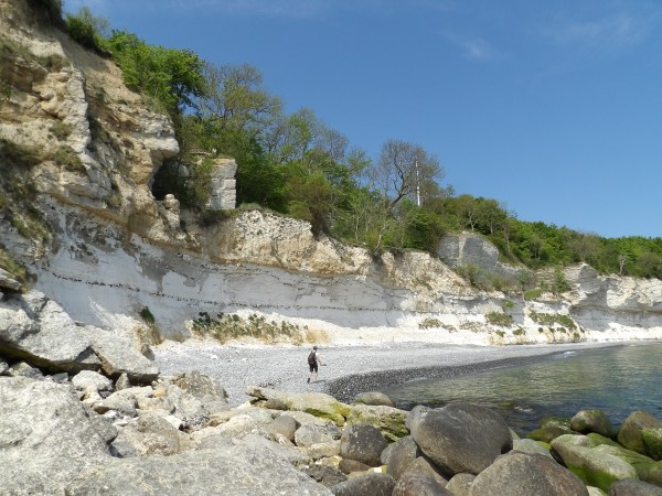
Located on the eastern coast of Zealand, Stevns Klint is a stunning 15-kilometer-long white chalk cliff that doesn’t just offer breathtaking views, but holds a story that changed the history of life on Earth. Recognized as a UNESCO World Heritage Site, this cliff is one of the most scientifically important locations in the world for understanding the mass extinction that wiped out the dinosaurs.
Where dinosaurs met their end
What makes Stevns Klint so unique is a thin, dark layer of clay found within its layers of chalk and limestone. Known as the “fish clay”, this band is rich in iridium, a rare element more commonly found in asteroids than on Earth. This thin layer marks the Cretaceous-Paleogene (K-Pg) boundary, about 66 million years ago, and provides compelling evidence that a giant asteroid struck Earth – the same event believed to have triggered the extinction of nearly 75% of all species, including the non-avian dinosaurs.
The chalky cliffs at Stevns Klint
As you can imagine, the cliff is a paradise for geologists and paleontologists. My flat-mate, also a geologist was ecstatic. Before moving to Denmark he worked as a paleontologist on a research project in Romania. This was right up his alley.
The fish clay-extinction band running along the side of the cliff
Fossils preserved in the chalk layers above and below the iridium-rich boundary reveal a vivid picture of life before and after the impact. Tiny marine organisms like foraminifera show a sharp decline right at the boundary, offering one of the clearest extinction markers in the world. Scientists continue to study Stevns Klint to understand not only how life vanished but also how it rebounded in the aftermath.
Bonus modern attractions
Surprisingly enough, Stevns Klint isn’t just about ancient history. The geological features of the cliff weren’t news to me, but as we discovered the area also had stories from more recent times. Perched dramatically at the cliff’s edge is Højerup Church, a medieval church built around 1250. At the time located safely inland, but over the centuries inching ever closer to the edge due to relentless erosion of the cliff.
Højerup Church
For generations, the local legend warned that the cliff was retreating, inch by inch. In fact, there’s a Danish saying: “The church moves one cock-step closer to the sea every Christmas Eve.” While poetic, that warning became very real on March 16, 1928, when a large section of the cliff collapsed, taking the entire eastern part of the structure with it. Immediately decommissioned for religious services, the locals rallied to preserve what remained of the church.
The back of Højerup Church inching towards the sea
Beneath the cliffs, hidden in the limestone, is another surprise attraction. Namely the Stevnsfort Cold War Museum, a once-secret fortress built to withstand nuclear attacks during the Cold War.
Stevnsfort
Built in 1953, at the height of Cold War tensions, Stevnsfort was part of NATO’s front line defense. Its strategic location on the coast of Zealand gave it a commanding view over the Øresund Strait, a crucial naval passage between the Baltic Sea and the North Sea. The fortress was designed to help detect and, if necessary, halt Soviet warships attempting to reach Western Europe.
Rocket artillery pieces on display in the museum courtyard
For decades, the site was fully operational and highly classified. It wasn’t until the early 2000’s that the base was officially decommissioned and turned into a museum. Even as a museum it’s so hidden from sight that we didn’t notice it until we were leaving Stevns Klint. Only then did the huge tank and rocket artillery on display in the courtyard catch my eye, spurring me to investigate.
Nothing like posing with the Centurion MBT in your cycling gear…
Unfortunately though, it was fairly late in the afternoon and we wouldn’t have had time for a proper visit before closing time. That’s one attraction I regret never taking the time to go back to while still living in Denmark.
Day trip to Sweden
A couple of months later, my friends and I were preparing for another excursion. I don’t recall how and why we decided on this, but we were basically going to visit Malmö in Sweden for half a day.
Located just across the Øresund strait from Copenhagen, Malmö is the third largest city on Sweden and the largest city in the southernmost province of Skåne. The two cities are linked by one of Europe’s most impressive feats of engineering, the Øresund bridge.
The Øresund bridge on a muggy morning, seen from the Danish side
Opened in 2000, this impressive structure not only connected the two Nordic cities, but also formed a vital artery between Scandinavia and the rest of Europe. Spanning approximately 16 kilometers in total, the crossing combines a 7.8 km cable-stayed bridge with a 4 km underwater tunnel, joined in the middle by an artificial island named Peberholm. Accommodating both a 4-lane motorway and a dual-track railway, the bridge has become a cultural icon, famously featured in Nordic noir television and admired for its sleek design and ambitious scale.
The Øresundståg train, was the most convenient option for us. You can board it at several stations on the Danish side, including Copenhagen Central, Nørreport, Østerport stations, as well as Kastrup at Copenhagen Airport. The ride lasted about 40 minutes from downtown Copenhagen. Before we knew it we were already in Sweden.
Malmö
Once an industrial port town, Malmö has undergone a drastic transformation into a modern, eco-conscious city. So much so that it has taken the top on the list of Europe’s greenest cities.
Walking around Malmö
One of the most striking symbols of Malmö’s reinvention is the Turning Torso, a twisting skyscraper designed by Santiago Calatrava, which towers over the city’s redeveloped Western Harbour (Västra Hamnen). This area, once a shipyard, is now a model for sustainable urban living, featuring energy-efficient buildings, green spaces, and a popular seaside promenade.
The Turning Torso skyscraper in Malmö
Close encounter of the green kind
Malmö is also known for its strong tradition of activism and social engagement. It has long been a politically progressive city, often leaning left in Sweden’s political spectrum. It has a history of grassroots organizing and is home to numerous NGOs, cultural centers, and activist groups advocating for equality, justice, and environmental sustainability. I bring this up because even during our short visit we ran across activists engaging with people on the streets.
Dude just casually kite surfing the canals in Malmö
In our case, it was a vocal group advocating for veganism to combat animal cruelty and industrial farming through reduction of meat consumption. As much as we sympathized with the cause, we were not really the right target audience for their campaign, as at least at the time, we were all uncompromising meat-eaters. This lead to a few snarky remarks and “troll-face” exchanges, which the activists were not pleased with.
We weren’t there to please them, of course, just to explore and have a bit of fun, even if it meant rolling our eyes at a few preachy, virtue-signaling activists parading their self-fed moral superiority for all to admire.
Old town
Despite its modernity, Malmö still honors its historical roots. The medieval Stortorget and Lilla Torg squares are nestled among charming cobblestone streets in the old town, while landmarks like St. Peter’s Church offer a glimpse into the city’s rich past.
Statue of Karl X Gustav in Stortorget
The architecture in this area showcases the city’s rich history, with a blend of Renaissance, Baroque, and Neo-Gothic styles, similar to Copenhagen’s historic center. The nearby Malmöhus Castle, a Renaissance fortress now housing museums and exhibitions, stands as a testament to centuries of regional history.
Ready to go home after a day of exploring Malmö
After walking around the harbor and central areas for a few hours, we plopped down in the city’s main square and soaked in the afternoon sun. With a pleasant day of city-exploring behind us, we were ready to head back to the train station and Copenhagen.
During late November, 2017, while I was routinely scrolling through my Facebook feed, a random ad post caught my eye. It was from DFDS, a Danish international shipping and logistics company, and read something like “The cheapest ferry ride ever”, roundtrip from Copenhagen to Oslo.
With a raised eyebrow, and high skepticism I decided to check it out on their website and, it was indeed legit. Copenhagen to Oslo, round trip on selected dates within the next couple of weeks for 2 DKK… I repeat, TWO KRONER… That’s less than a dollar!
Full moon spontaneity
This was one of those rare opportunities for a spontaneous adventure that I couldn’t pass up. However, I hoped to get at least one of my friends on board to go with. This wasn’t the easiest thing to do as most of my friends were working at the time and couldn’t, or wouldn’t just want to suddenly take time off. Having recently graduated, I had the “luxury” of still being unemployed. Luckily, there was at least one other person I could think of in a similar boat.
None other than Eddy, my Nigerian colleague and close friend from KU who had also recently graduated and was job-searching. I quickly reached out to him with a proposal to take a break from the mundane and to join me on the cheapest ferry ride ever.
Setting sail
Within a week or so, Eddy and I were ready to embark on our dirt cheap journey to Norway. The ferry departs daily at 16:40 from Copenhagen and arrives in Oslo the next morning at around 10:00. It stays in port until around the same time in the afternoon before returning to Copenhagen. To keep to the theme of cheapest trip ever, both of us made sure to pack enough sandwiches to last us through the outbound journey.
Nordhavn, Copenhagen, before departure
Once on board, we left our things in our cabin in the bowels of the ship and rushed up and out onto the deck to enjoy the view; and what a view it was… Since it was around early December, it was already nightfall by the time we were supposed to leave. Copenhagen’s lights glimmered and shined against the fading hues of the late sunset, their reflections dancing over the dark, rippling waters.
Not long after, the ship began to slowly drift away from the shore. As we floated away, the bay of Nordhavn offered some excellent photo opportunities that I couldn’t pass up. The downside was that the chilly wind and ship’s movements made it hard to get a clean shot since my camera didn’t have stabilizer.
Eddy and I, ready to set sail
After leaving Copenhagen behind, we returned to our rooms to warm up and rest. This was my first time traveling on a big ship and I was curious if and how the rocking motion would affect me. For the first hours of the trip we could barely feel any movement. Eddy fell asleep and I sat in my bed reading and doom-scrolling through my phone.
The Kattegat sea
A couple of hours into our trip, the rocking had begun. It was very subtle at first, especially while laying in bed, but I noticed that I’d constantly have to reposition myself as I kept sliding off the bed. The novelty of this excited me and I immediately got up to go topside.
Old photos of ferry ships of the DFDS fleet on display
We had now left the calm waters of the Øresund strait and were sailing into the much more turbulent Kattegat sea. As I walked towards the deck, the rocking was way more prevalent. It wasn’t bad by any means, but it felt and looked as if everyone on the ship was a bit drunk. Once I got out, I was instantly hit by rushing cold winds and water droplets from the waves smashing into the side of the hull.
It felt bad enough that I didn’t want to get anywhere near the handrails. Instead, I kept close to the walls and enjoyed the raw elements battering our ship in the night from a safe distance. I was also pleasantly relieved that I didn’t feel any motion sickness. In fact the entire night trip was quite pleasant and I think all that rocking even helped put me to sleep faster.
Arriving in Oslo
When we got up the next morning, we finished our sandwiches and rushed back up onto the deck to be greeted by the sights of the Oslofjord.
Sailing through the Oslofjord
Sailing past residential and industrial buildings scattered across the surrounding hills, our ship slowly but surely made its way along the fjord and into the port of Oslo. As we turned to dock, one building in particular stuck out with its bold, modern, angular shape. Namely the Oslo Opera House, situated in Oslo harbor.
Oslo Opera House looking like an iceberg
After disembarking, Eddy and I wandered off into the busy streets of the city for a day of sightseeing.
Oslo
Arriving in Oslo feels like stepping into a city that balances its rich past with a crisp, modern energy. The Norwegian capital, founded over a thousand years ago during the Viking Age, has grown from a medieval trading post into a vibrant waterfront city. Walking along the harbor at Aker Brygge, you can see sleek new buildings standing beside old wooden piers, where merchant ships once unloaded goods from across Europe.
Oslo harbor from the ship’s deck
Heading inland, we followed the wide, clean streets past the striking Oslo City Hall, a huge red-brick building famous for hosting the Nobel Peace Prize ceremony. Its twin towers loom above the harbor, decorated with murals and carvings that tell stories of Norway’s seafaring and working-class roots. From there, the city begins to open up.
Oslo City Hall (Rådhus)
Crossing into the city center, we passed through the People’s Theater (Folketeateret), an art deco building that once hosted grand operas and plays, and today holds concerts and modern performances under its stately old signage.
Folketeatret, also home to a weird sculpture of Kate Moss in a yoga position, among other things
As we continued along some of the side streets, we came across this amusing giraffe mural on one of the buildings, its long neck and goofy-looking face resembling ET the extraterrestrial.
ET the giraffe
After about an hour of strolling through the streets, we arrived at the The Royal Palace (Det kongelige slott), located at the end of Karl Johans gate, the main boulevard of the city. Built between 1824 and 1848, the palace is the official residence of the Norwegian monarch.
Ain’t nothing like being back in Norway!
Standing as a historic landmark, the royal residence was originally built for King Charles III John, the first king of Norway after the country gained independence from Denmark.
Jul i Vinterland
Heading back from The Royal Palace, we passed by the central part of the University of Oslo’s historic campus and the Norwegian parliament building. It was around noon, so we were on the lookout for a cheap place to grab a bite. Not something easy to find in the center of Oslo.
University of Oslo building in the city center
As we strolled along Karl Johans gate, we came across “Jul i Vinterland”, Oslo’s largest and most iconic Christmas market. Located in Spikersuppa, a city square between the National Theatre and the Royal Palace, the enchanting market transforms the heart of the city into a festive wonderland each winter.
Oslo’s Christmas market
At the center of the market was an open-air ice skating rink, free for all to enjoy. Surrounded by twinkling lights and festive music, it provided a perfect setting for skating enthusiasts and families alike. Various amusement rides dotted the square, including a 40-meter-high Ferris wheel providing panoramic views of the city.
Food and drink stalls at Jul i Vinterland
All across the square bustling stalls offered a variety of gifts, clothing, toys, and culinary delights. We couldn’t pass up the chance to enjoy a cup of gløgg (mulled wine) while we were there.
Nothing like a cup of gløgg on a cold December day
As we stood there in the cool outdoors enjoying our hot beverage, the first snowflakes of the season started coming down, marking the start of winter. Even if it barely lasted a few minutes, it was just such a perfectly hygge moment… Being back in Norway and enjoying a hot drink in a festive atmosphere with one of my dearest friends while witnessing the first snowfall of the end of 2017.
Oslo harbor and heading back home
After leaving the market, we found a reasonably priced place to have a quick lunch and then made our way back to the harbor. We strolled around there for another hour, or two until it was time to head back to the ferry.
The Diver (Dykkaren) located along the harbor promenade
This was now my third time visiting Norway and thus far each of my visits had these memorable “feel good” moments that I will never forget. Be it the peaceful solitude of the lonely mountain high above the fjords in Borgund, the vivid sunset reddening the sky in Jostedalsbreen National Park, or the first snowfall at Oslo’s cozy Christmas market.
There was definitely something special about this country for me. Something that kept calling me back. Whether this would lead to a more permanent move there in the future was anyone’s guess. For the moment, it was time to head back home to Denmark.
Adios Oslo. Until next time!
That night on the ferry, Eddy and I decided to dine out on the ship. Even if a bit pricey, after this incredibly cheap little holiday we felt we deserved a little indulging. Plus, this was my way poor-man’s way of paying back DFDS for this awesome opportunity that basically cost nothing.
A delicious steak and beer dinner on the ferry
While enjoying our steaks and fancy beers, I kept thinking of if and when will the day come that an experience like dining out on a ship won’t feel like indulging in a once in a lifetime financial expense. Will there ever be a time when I can just enjoy things without constantly looking at the costs? Maybe… Hopefully.
Hoisting up the Danish flag. We’re coming home!
The next morning, while we were back sailing in the calm Øresund strait towards Copenhagen, I was out on the deck looking out at the horizon, wondering what the future holds. Even with all the ups and downs of life, and constant financial difficulties, as long as the good stories and adventures kept flowing, life was pretty darn good and worthwhile.
About a month after our big cycling trip to Helsingør, my flat mate and I were on our bikes again. This time around, we were cycling to Roskilde. During my time in Denmark, I had heard many times of this historic city 30 km west of Copenhagen, mostly in the context of its famous summer festival. Even though I never got around to attend it, I figured it was high time I payed this historic city a visit.
Cycling to Roskilde
The weather was a bit muggy that day, not too warm, not too cold, with a constant breeze blowing long hair into eyes. Basically, your typical Danish summer day. Starting from Farum early in the morning, we cycled for about two hours through the Danish countryside. This mostly consisted of lush farmlands interrupted by occasional small towns. Not as eye-pleasing as the coastal road we had done during our last trip, but the backroads were pretty good for biking, and there was little to no traffic.
Roskilde
We reached Roskilde by the northern road following the Roskilde fjord. The fjord being one of the key elements of this old Viking town. Founded during the Viking Age, the city became an important trading hub and a center of power for Danish kings. According to legend, Harald Bluetooth, the king who helped unify Denmark and convert it to Christianity, established Roskilde as a royal seat in the 10th century.
Roskilde fjord
During the medieval period, Roskilde grew into a major religious center. The construction of Roskilde Cathedral in the 12th and 13th centuries solidified the city’s importance. This UNESCO World Heritage site is the final resting place of Danish monarchs, with over 40 kings and queens buried within its walls. The cathedral’s Gothic brick architecture and historical significance make it a key landmark in Denmark’s cultural heritage.
Roskilde Cathedral
Despite losing its status as Denmark’s capital to Copenhagen in the 15th century, Roskilde remained a vital city. It continued to be a religious and economic center, playing a key role in regional trade.
The 5 m tall Roskilde Jars (Roskilde Krukkerne) created by Danish artist Peter Brandes in 1998
In modern times, the famous Roskilde Festival I mentioned previously is one of Europe’s largest music festivals and well worth experiencing. Outside of festival season, the Viking Ship Museum is the city’s top attraction.
The Viking Ship Museum
After cycling around the city center for a while, we headed to the famous Viking Ship Museum. Located along the Roskilde Fjord, the museum is dedicated to Viking maritime culture and shipbuilding. It is best known for its collection of five original Viking ships, known as the Skuldelev ships, which were excavated from the fjord in the 1960s.
The Viking Ship Museum in Roskilde
The Skuldelev ships date back to the 11th century and were deliberately sunk to create a barrier against enemy attacks on Roskilde. Each of the five ships served a distinct purpose: one was a long, narrow warship built for speed and raids, while another was a sturdy trading vessel designed to carry cargo across long distances. The remaining ships included a coastal trader and smaller boats used for fishing and local transport.
Recovered Viking ships on display at the museum
The discovery of these ships provided invaluable insights into Viking shipbuilding techniques, maritime warfare, and daily life on the sea. Aside from the exhibits, the museum offers a hands-on experience with Viking shipbuilding techniques. Visitors can watch skilled craftsmen use traditional techniques in full-scale reconstructions of the original ships.
Ship building workshop
During the summer months, visitors can also hop on board one of the reconstructed Viking ships for a rowing experience through the fjord. Before setting off, participants receive instructions from museum staff on Viking rowing techniques, teamwork, and navigation.
Museum visitors rowing away in their Viking ship
A synchronized effort is required to keep the vessel moving smoothly, so rowers must follow the rhythm set by the crew leader. If conditions are right, the sail can also help them out.
A worthwhile visit
After our visit to the museum, we slowly made our way back towards Farum. Another two hours across the peaceful Danish countryside. The sun finally decided to come out to greet us in the afternoon as we rode back. Even though our trip to Roskilde was rather short, the Viking Ship Museum made it worthwhile. I would highly recommend a visit, especially to any Viking enthusiasts out there!
My main objective in 2017 was finishing my Masters thesis. It was going to be a highly work-intensive year with no plans to travel abroad. Cycling had always helped me relax and clear my mind in the past. So in my attempts to cope with the stress and mental fatigue of a demanding year, 2017 would turn out to be a year of cycling and exploring Eastern Denmark.
Cycling: The solution to everything
After moving to Farum at the end of 2016, I was heavily reliant on the Danish S-trains to get into Copenhagen for work. Luckily the trains were fitted with plenty of bicycle areas so passengers could bring their bikes aboard. However, things would get very chaotic during rush hours when the train would be absolutely packed with bike-wielding people. If you were unfortunate enough to be stuck in the middle, you’d have no chance of getting out in time for your stop.
Late winter in the Danish forests
To avoid the nuisance of train chaos, I began cycling back home, instead of taking the S-train. Cycling the 20 km distance would take me just around 30 minutes extra, but it would be much more rewarding. Especially on a beautiful sunset evening with good weather!
Cycling also became my solution to keeping up my gym routine. Farum didn’t have a FitnessDK gym, which I was a member of, and I wouldn’t always want to go all the way to Copenhagen just to work out. Instead, I would cycle to the nearby village of Birkerød. Thus Farum-Birkerød became another regular cycling route.
An old friend
A few months into the year, a close friend of mine from my undergrad years decided to move to Denmark for a fresh start. At around the same time, my old flat-mate was moving out, so my friend Cipri moved in in his place. I had really talked up the Danish cycling culture to him and he was keen on getting into it.
Throughout the year we did several long day rides across the island of Zealand. From Helsingør and Hillerød, to as far as Steven’s Klint in the south and Gilleleje at the top north of eastern Denmark.
Cipri and I on our Helsingør cycling trip
Our first big cycling trip of the year was Copenhagen to Helsingør and then back to Farum. A respectable 85 to 90 km ride that would take us the better part of the day.
A gorgeous day trip to Helsingør
We set out on our big cycling trip on the 20th of May. It was a gorgeous sunny day. Nice and warm with a constant gentle breeze. We took the S-train to Østerport and started cycling from there. The reason I didn’t want to start from Farum was to show Cipri the beautiful coastal road heading up north from Copenhagen.
A great day for water activities and biking along the coast
Starting off with the beautiful neighborhoods at the outskirts of the Copenhagen, the road passed by my old “sanctuary” at Charlottenlund beach park. After passing the last vestige of outer-Copenhagen at Klampenborg, the road followed along the eastern edge of the beautiful, forested Deer Park.
Danish peer in the foreground, Swedish coast in the background
Occasionally losing sight of the coast, the road to Helsingør, continued north with intermittent beaches and marinas on the Øresund straight. Given the beautiful weather that day, a rarity in Denmark, the seawaters were filled sailboats and various other pleasure-crafts.
Sailboat on the Øresund
For the next stretch, the road would cross several wealthy coastal small towns and neighborhoods, offering endless appealing sights to admire. This was by far my favorite cycling route in Denmark.
Helsingør
After a few hours of cycling we had arrived at Helsingør. The coastal road now continued along the Helsingør harbor and waterfront. There, daily ferries connect Helsingør to Helsingborg (Sweden) across the narrowest part of the Øresund straight. Once a key maritime trade hub, the harbor now blends history with modern attractions, featuring lively promenades, seafood restaurants, and cultural landmarks like the Culture Yard (Kulturværftet).
Helsingør harbor and the ferry to Helsingborg
Continuing along the coast, we stumbled upon a curious sculpture. Known as the “Garbage Fish” it was created in 2014 by Japanese artist Hideaki Shibata from plastic waste collected from the sea. The sculpture serves as a powerful reminder of the environmental impact of marine debris and emphasizes the importance of recycling and waste management.
The colorful Garbage Fish. A landmark in Helsingør
Further along the waterworks, we reached Helsingør top attraction and my destination point for the day: Kronborg Castle.
The history of Kronborg Castle
Designated a UNESCO World Heritage Site, Kronborg Castle is one of the most famous Renaissance castles in Europe. Tthe castle is renowned for its role in Shakespeare’s Hamlet and its strategic location controlling the Øresund Strait. With a rich history spanning over 600 years, Kronborg has been a royal residence, military fortress, and cultural landmark.
Kronborg Castle courtyard from the top floor
The site of Kronborg Castle was originally home to Krogen, a medieval fortress built in the early 15th century by King Eric of Pomerania. Its purpose was to enforce the Sound Toll, a tax on ships passing through the Øresund Strait, making it a crucial part of Denmark’s economy. The revenue from this toll contributed significantly to the Danish crown’s wealth for centuries.
The row of cannons along the battlements pointed towards the Øresund Strait
A grand Renaissance castle
In the late 16th century, King Frederick II ordered the transformation of Krogen into a grand Renaissance castle, renaming it Kronborg. Influenced by Dutch and Flemish architectural styles, the new structure featured ornate towers, decorative facades, and elegant interiors. Under Frederick II, Kronborg became one of the most splendid castles in Northern Europe and a symbol of Denmark’s power.
Dining table in one of the many rooms at Kronborg
In 1629, a massive fire broke out, destroying much of the castle’s interior. However, the outer walls remained intact, allowing King Christian IV to rebuild it in a similar style. The new interiors were less extravagant but retained the fortress’s grandeur.
Holger Danske, the eternal protector of Denmark in Danish folklore
In 1658, Kronborg was captured by Swedish forces during the Dano-Swedish War. Though they plundered the castle’s valuables, it was later returned to Danish control. Over time, Kronborg evolved into a military barracks, housing soldiers for nearly 200 years until 1857, when it ceased military operations and was restored as a cultural landmark.
Sights and thoughts
The fortress boasts around 40 rooms that are open for visitors, as well as the dungeon. The rooms range from royal dining rooms and bedrooms to game rooms and study rooms. The Chapel remains as one of the best preserved parts of Kronborg and the only section that survived the devastating 1629 fire untouched.
Kronborg inner courtyard and clock tower
The dungeon bellow offered its own interesting story, from casemates to beer cellars. our tour guide told us about how Danish soldiers of old would drink several beer a day instead of water because the water was so polluted. A hardy bunch!
View of Helsingør harbor from the castle tower
On top of all this, the outside views like the inner and outer courtyard, as well as the rooftop terrace offer fantastic views of the fortress and it’s surroundings. One could easily spend hours in and around Kronborg and I would highly recommend a visit to this historic Castle to anyone planning a trip to Denmark.
On top of the fortress
I highly enjoyed my tour, but I tried not to dawdle too much. After all, we still had two and a half hours of cycling left to get back home. With sun in our face, we bolted off towards Farum. In total, cycling around five hours that day.
On the morning following our road trip to Briksdalsbreen, we were back in Fjærland. The plan was to drive back to Trondheim that day. On our drive back we would end up paying an unexpected visit to a very familiar place from back when we traveled to Norway the first time.
I just love these grassy rooftop wooden cabins
Before heading out, however, we had to pay the glaciers another visit. This time around we settled for a closer option and walked to the base of Bøyabreen glacier.
At a short distance from the Norwegian Glacier Museum, Bøyabreen is an arm of the the larger Jostedalsbreen Glacier. From the rainy clouds above thick blue ice lurched down the steep mountains towards the glacial lake beneath. Several streams originating from the ice sheet above came down the rocky cliffs forming series of thin waterfalls all around.
Bøyabreen glacier, Fjærland
It was a splendid view. One that could only be honored with a photo reenactment of Michelangelo’s “The Creation of Adam”.
Just as good if not better than the original
An unexpected visit to a familiar place
On our way back to Trondheim we stopped in a small town by the fjord to gas up the car. Since I wasn’t using my google maps back then as much as I do today, I had no idea where we were. Then Daniel pointed out that we were in fact back in Sogndalsfjøra.
With that realization came back the memories from our time there three years before. During our first adventure in Norway when we sought out fjords and mountains, Sogndalsfjøra was the furthest we got northwest. I brought up the idea of driving all the way back to Fagernes and our favorite campsite.
A stop down memory lane: Sogndalsfjøra, 2016
However, we still had a long drive to do back north to Trondheim. So we decided to skip on that idea. Still, it was great to see that little town filled with great memories.
Mountains and the church
On our way back north, we followed Lustrafjorden across the Jostedalsbreen National Park and passed into the Jotunheimen National Park. A stunning alpine wilderness renowned for its towering peaks, deep valleys, and pristine lakes, Jotunheimen is known as the “Home of the Giants”.
Driving through the Jotunheimen National Park
The rugged terrain of Jotunheimen is deeply rooted in Norse mythology as it was traditionally considered the realm of the Jötnar, the frost and rock giants. In Norse tales, the Jötnar were both adversaries and occasional allies of the gods. Thor, the god of thunder, frequently ventured into Jotunheim to battle these formidable beings, showcasing his strength and bravery. Meanwhile, Loki, himself of Jötunn descent, often served as a bridge between the two worlds, blending conflict with cunning alliances.
Glacier creeping across the Jotunheim mountains
The park is a paradise for hikers and climbers, featuring 29 of Norway’s highest mountains, including Galdhøpiggen, the tallest in Northern Europe.
Lom stave church
After crossing Jotunheimen we soon arrived in the village of Lom. There we made one final stop and visited Lom Stavkyrkje, one of the largest and best-preserved stave churches in Norway. Originally built in 12th century, its intricate carvings depict Christian symbols alongside Norse pagan motifs, reflecting the transitional period between paganism and Christianity in Norway.
Interior of the Lom stave church
Later modifications added medieval touches such as extended aisles and windows. The interior also reflects a more medieval and Renaissance style including painted decorations, artifacts and a preserved altarpiece.
Shopping across borders
The following day Daniel needed to do some bulk grocery shopping, so we hopped into the car and paid Sweden an unexpected visit… Yeah, so apparently it’s a fairly common thing for Norwegians living close to the border to cross over to Sweden to do their bulk shopping since it’s significantly cheaper. In fact, there are even dedicated shopping centers on the Swedish side built close to the border for this specific purpose. One of them was located in the small town of Storlien, about a one and a half hour drive from Trondheim.
On a shopping trip to Sweden
The weather was much better that day. Mostly sunny, with just a few scattered clouds. The landscape was quite impressive as well. Rounded, rocky mountains stuck out from the vibrant autumn colored vegetation and swampy terrain stretching in all directions.
Plenty of blueberries to snack on while hiking
At this point we had crossed over to Sweden and my adventure senses were tingling. I managed to talk Daniel into hiking one of the nearby nameless mountains. So we set off through the bushy and hilly terrain, munching on plenty of blueberries along the way.
Conquering the nameless Swedish mountains
As far as the eye could see, there was nothing but pristine wilderness. The walk reminded me of our Borgund mountain hike from three years before. Once more it felt like we were the only people around for hundreds of miles. Quiet, peaceful, tranquil. Well, as long as you ignored the main road we started walking from.
It’s not obvious from the photo, but my tongue was berry-blue
After reaching one of the cliffs and fulfilling our daily adventure-o-meter, we were ready to head back and finish our grocery shopping quest.
Our brief visit to Storlien, Sweden
Trondheim
I spend the rest of my remaining time in Norway in and around Trondheim. In the evening, Daniel took me to one of his favorite spots on the fjord to show off his highly improved fishing skills. By this point he was apparently becoming quite the fisherman, but alas, no fish were caught that night.
Should have just fished with the crane
On my last day we strolled around in Trondheim’s city center. One of the most iconic buildings was Nidaros Cathedral. An impressive Gothic/Romanesque cathedral, Nidaros has been a sacred site for pilgrims throughout the middle ages. The cathedral also stands as a symbol of Norwegian national identity and heritage where most of the country’s monarchs have been consecrated throughout its history.
The intricate façade of Nidaros Cathedral in Trondheim
Apart from religious services and royal ceremonies, the cathedral also hosts numerous cultural events year round. These events range from concerts to art shows, with the most famous one being the annual St. Olav Festival, which includes medieval markets and special church services.
The Statue of Saint Olaf up on a high pedestal near Nidaros Cathedral
Another iconic part of Trondheim is the neighborhood of Bakklandet. Located on the east side of the Nidelva River, just across from the city center, the area features a set of 17th century colorful wooden houses with cultural significance. The vibrant color style reminded me of other famous Scandinavian neighborhoods, like Nyhavn in Copenhagen, Denmark.
Bakklandet neighborhood in Trondheim
After strolling around the city for half the day, it was once more time for me to depart Norway. I knew I was going to come back again, sooner or later. But for now, I had to return to my life in Denmark.
Following my two-weeks adventure in Iceland in August 2016, I returned to Denmark. However, it wasn’t for long as I was planning another little trip. This time non-work related. During the time I had moved and settled in Denmark, one of my best friends from back in Romania, Daniel, had decided to move to Norway. The promised land, the land of an unforgettable adventure that started it all for both of us. Now that I was financially stable and settled into my new life, it was time to return to the far north and reunite the brotherhood!
Thus just a few weeks after my return from Iceland, I took a flight from Copenhagen to Trondheim to visit my best buddy in Norway.
Once more above the clouds
Back in Norway
I got to Trondheim pretty late at night. By the time Daniel picked me up and we got back to his place his then girlfriend was sleeping. As was most of the neighborhood. I remember we sat out on the porch during the cool Norwegian night drinking and chatting away while trying to keep our voices down.
We had a lot to catch up on since both of our lives had radically changed since last we met. However, no matter how much had changed, how much we’d change, we would always seamlessly pick up right where we left off.
After one and a half year, the Brotherhood reunites!
The next day was a Friday and Daniel had planned a little road trip for us over the weekend. After a lazy morning, he had to run some errands in the city so I tagged along and got my first brief view of Trondheim.
Driving around Trondheim, Norway
Around noon we drove over to the one of the University of Trondheim locations to pick up his girlfriend. As I was waiting, I remember admiring this casually parked submarine in the harbor right next to the building.
This is not the yellow submarine
Soon enough, we were all packed up and ready to hit the road for the weekend.
Jostedalsbreen National Park
For the rest of the day and well into the night we drove to the Jostedalsbreen National Park, mainland Europe’s largest glacier. We couldn’t see much of anything during our night drive, but the next morning we were treated to quite a spectacular view.
A cool, misty morning in Jostedalsbreen National Park
We woke up in the heart of the national park, somewhere in, or near Fjærland. It was like poetic justice that we started off our trip in the place that we were eyeing three years before, from across the fjords and mountains in Søgndal. I have to admit though, for the better part of this trip, I had no idea where we were. I was just marveling at our surroundings and enjoying the adventure.
Norwegian Glacier Museum in Fjærland
Our first stop of the day was the Norwegian Glacier Museum in Fjærland. The museum showcases the science of glaciology, the history of glaciers in Norway, and their role in climate change. It featured interactive exhibits, models, and presentations on the topic.
Glacier model at the Norwegian Glacier Museum
The museum also highlights the cultural significance of glaciers in Norway’s history and provides insight into the challenges and importance of preserving these natural wonders. But best of all, the museum had a big polar bear in the lobby area that I could high five!
Heck yeah!
Melkevoll Bretun
Following a scenic drive around and under the mountains, we ended up on the northern side of the glacier, at Melkevoll Bretun. Located near the Briksdal Glacier (Briksdalsbreen) in Stryn, Melkevoll Bretun offers stunning views of dramatic glacial landscapes. It was time for a little hike.
The trail to Briksdalsbreen glacial lake
A 3 km trail from Briksdal Mountain Lodge led all the way up to the Briksdalsbreen glacial lake. The winding gravel trail took us up the mountain through lush valleys surrounded by towering peaks and cascading waterfalls. On our way up we passed Kleivafossen waterfall, one of the major highlights of the the hike.
Kleivafossen waterfall spraying everyone that passed it by
Following the waterfall we passed by some cool glacial features in the outcropping rocks. Jettegryter, or the giant potholes formed naturally during the last Ice Age, when glacial meltwater carried rocks and debris that swirled in strong currents, grinding into the bedrock.
The giant potholes (Jettegryter) on the Briksdalsbreen trail
The polished, smooth wall of the rocks also revealed other neat features in these rocks that would excite any geology enthusiast.
Structural features in the rock layers, including displacement and boudinage
Of course a Norwegian hike wouldn’t be complete without encountering a pack of goats. Most of them were minding their own business, grazing around. But then there was this one goat perched up on a rock that was just staring down at us lowly humans like the king that he was.
Close encounter with the Goat King
Briksdalsbreen
Shortly after our encounter with the Goat King, we reached Briksdalsbreen glacial lake. A serene lake with a gorgeous view, Briksdalsbreen glacial lake continues to grow larger as the glacier gradually retreats over the decades.
Briksdalsbreen, an arm of the larger Jostedalsbreen ice cap
This was one of the best places to test out my newly acquired PENTAX digital camera. It wasn’t as fancy as a Canon, or Nikon, but its fixed lens had quite an impressive zoom for the time. The only problem was keeping the camera steady. I never invested in a tripod, so I had to always find just the right surface around to get my zoomed in shots.
Briksdalsbreen zoomed in
I ended up getting some really neat zoomed in shots of the glacier. One of them even captured distinctive cracks/crevasses in the blue ice.
Even more zoomed in action revealing cracks in the ice
Of course I couldn’t just ignore the jagged mountain peaks surrounding us. After a quick camera repositioning, I got some moody shots of the landscape as well.
Ice patches tucked away between the surrounding mountain ridges
Finally, Daniel ended up just in the right spot for a spaghetti western style shot!
The man, the viking, the legend, Dovahkiin Daniel
An epic sunset
After we finished our nature photoshoot at Briksdalsbreen, we slowly headed back to the parking lot. As we drove back towards our lodging, the clouds led up just enough to offer some amazing sunset views that just kept on getting better and better.
Sunlight just barely grazing the peaks of the mountains
Even Daniel was constantly staring into his mirrors while driving while we were “oo-ing” and “aa-ing” at the scenery. We ended up pulling over numerous times to get the best shots.
Jostedalsbreen in the distance
But it wasn’t until the apex of the setting sun that we were truly treated to some spectacular sights.
An epic Norwegian sunset
Nothing like a lake view of the burning red sky as the sun goes down behind the mountains and fjords. A perfect way to end a great day on the road. However, our adventures in Norway were not over yet. The story will continue in “The return to Norway part 2”.
Having now journeyed across most of the country for the last 10 days, our adventure in Iceland was soon coming to an end. With but a few days left to travel across the south of the country, I thought that I had seen everything this volcanic island’s landscape had to offer. However, to my surprise, the south would provide a radically different environment then what I’d seen thus far. There, the unrelenting waves of the Atlantic constantly battered the shore, while moody, dark clouds kept the tall looming cliffs in a constant shade. In contrast to the desolate volcanic wastes of central Iceland, the south was a mystical place where valleys whisper and icebergs are born.
The gloomy, shadowy southern coast of Iceland
Southern Iceland
We drove from Laugarfell south to get back on the ring road. It was an overcast day. Quite typical of southern Iceland since the weather there is heavily influenced by the North Atlantic Ocean. The combination of the oceanic climate and proximity to the Arctic Circle means that weather can be highly unpredictable, with constant cloud cover, rain, and wind. Furthermore, the mountainous terrain exacerbates this, creating microclimates. It’s not a stretch to say it’s an entirely different land than the arid center, or the calmer north.
The clouds were there for good
After driving across green mountainous lands, in and out of tunnels, we arrived at the coast. The road followed the coastline and the visual was quite impressive. On the one side there was the vast North Atlantic Ocean, relentlessly battering the coastline. On the other side, towering cliffs loomed above us with their tops hidden by thick, low-hanging dark grey clouds.
A place I would have loved to explore more
As the road swerved around the base of the cliffs, I’d occasionally get a glimpse of thin waterfall, or a narrow valley hidden in the constant mist. On one occasion the fog lifted just enough to reveal an icy “limb” of the Vatnajökull glacier creeping down from one of those narrow valleys. The eerie sight reminded me of the “Paths of the Dead” valley from the Lord of the Rings.
Jökulsárlón
Every now and again there would be a small wooden house nestled in under the cliffs. I could just imagine the kind of tales and sagas one would be able to write while living in a fantastical environment such as this. It was around that time that I began considering potentially moving to Iceland for a time. perhaps as part of a PhD? I probably wouldn’t have wanted to live out my whole life there, but a solid few years could have been incredible.
Some of the more visible waterfalls along the way
Some time later, we arrived at Jökulsárlón glacier lagoon. A stunning glacial lagoon, Jökulsárlón is where large chunks of ice break off from the Vatnajökull glacier and float in serene waters before drifting out into the Atlantic Ocean. It is basically a place where icebergs are born.
Where icebergs are born and with them the worries of Atlantic seafarers
This tranquil, peaceful area is surrounded by dramatic landscapes like the nearby black sand beaches giving it an otherworldly feel. This unique landscape is of course a highly popular tourist attraction, where masses of people congregate for photos and boat tours offering a closer view of the ice formations.
Natural ice sculpture: The shark and the spear fisherman
Truly it was one the busiest places we’d experience in Iceland. Probably even busier than downtown Reykjavik.
Highway to Hella
After our brief stop at Jökulsárlón, we continued west towards Hella. Our destination for the day was Beindalsholt, a guesthouse located on a farm near the village of Hella. On the way we made another stop south of Öræfajökull to collect some tephra samples for another study Paul was involved with.
On the side of the road, two pieces of mangled steel that used to belong to the Skeiðarárbrú bridge. The bridge was severely damaged by flooding in 1996 after a volcanic eruption in Grímsvötn. The remains now served as a monument to the raw power of Iceland’s volcanic and glacial forces.
Skeiðarárbrú bridge monument
As we drove further away from Vatnajökull, the landscape opened up revealing more waterfalls, hills and distant mountains. On the way Paul pointed out one of Iceland’s largest lava flows as we passed it by, the Laki fissure eruption.
The lush landscape of southern Iceland
The Laki eruption began in 1783 and lasted for eight months. The eruption that created a volcanic fissure system stretching over 27 kilometers released large quantities of lava and toxic gases like sulfur dioxide causing an environmental catastrophe. Evidence suggesting that the quantity of ash and gasses released caused a cooling period in the northern hemisphere that contributed to the “Year Without a Summer” in 1816.
Hekla and the highlands
The next day was to be our last day in the field. We had two final targets to sample. Located further northeast, to reach them we drove back once more toward the all too familiar wastelands of central Iceland. On our way we passed by one of Iceland’s most famous active volcanos, Hekla.
Driving by Hekla on our way north
At 1491 m high, Hekla is part of a 40 km wide volcanic system linked to the underlying rift between the Eurasian and North American tectonic plates. Notable for its frequent violent eruptions, Hekla is often referred to in Icelandic folklore as the Gateway to Hell.
One last trip into the Icelandic highlands
Contrary to Hekla, our target volcanoes, Saxi and Fontur were a lot less extravagant. In fact, they were relatively small phreatic craters composed of fine-grained unconsolidated crystal fragments. Once we reached Fontur, we realized we didn’t even need our geological hammers as we could simply scoop up a few fistfuls of loose crystals into our bags. Paul remarked that it was the most unorthodox sampling he had done so far.
Fresh olivine and plagioclase crystals, straight from Fontur
As we made our way back to the car, the weather turned bad. We took the opportunity to a have lunch and waited around in the car to see if we could ride out the rain. However it wasn’t going away and in the end we decided to pass on the hike to Saxi. After all, we had such a successful field campaign that we could afford missing out on one single sample.
The end to a great adventure
The day after, we drove back to Reykjavik. The sun came out to shine down on us one last time while on Icelandic soil. A few familiar sights greeted us on our way back. The moss-covered Laki lava fields followed us for the better part of the drive.
The friendly doggo at Beindalsholt greeting us in the morning
Later on, steam vents dotted the lush landscape as a constant reminder of the ongoing geothermal activity underneath. Finally the sights of increasing human activity dotted the rugged terrain as we approached the capital.
Moss covered lava flows from the Laki eruption
Once in Reykjavik the urban landscape took over completely. The rugged terrain replaced by wood, concrete and steel structures. Cars coming and going, and everyday people living their normal lives. A stark contrast to the harsh land they inhabit, as well as a testament to humanities nature to survive and thrive in the some of the most unforgivable places on Earth.
Walking around in Reykjavik
As my time in Iceland had come to a close, I walked the streets of Reykjavik one last time reflecting on the incredible sights I had seen. It had been a truly remarkable journey, filled with laughs, adventures and good times. It had also been an amazing mentor-student bonding experience between Paul and myself.
It’s been quite the ride, both living and retelling the journey
I believe that the details in which I could retell this story today, over 8 years later, are a tribute to the many fond memories gained during my trip there to Iceland. Hence, I will forever be thankful to Paul Martin for the opportunity to go to Iceland as part of my Masters thesis project.